Unique application of digital technologies improves operational efficiency
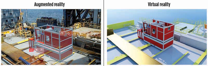
Until recently, augmented reality (AR) and virtual reality (VR) technologies were used primarily as entertainment products in the gaming industry. However, during the last 12 months, operators and service providers have increased AR/VR adoption for collaborative problem-solving, planning, and design applications to reduce costs and increase operational efficiency. AR represents a group of technologies that employ enhanced visualization hardware, techniques and methodologies. The combination of technologies creates new environments, wherein digital and physical objects and their data coexist and interact with one another, enhancing the user experience of the real world.1
VR represents a three-dimensional, computer-generated environment that can be explored and interacted with by a person. That person becomes part of this virtual world or is immersed within this environment and while there, can manipulate objects or perform a series of actions.2 Together, these technologies form the core of immersive experience and a new paradigm in industrial interaction. Halliburton Baroid has taken a lead in the adoption of this technology, in its strategy to help drive the industry’s digital transformation through lower costs and improvements in operational efficiency to help companies maximize asset value.
CHALLENGE
A traditional rig survey requires up to 10 days of specialist time, of which only three days is actually at the rig-site, followed by seven days for reporting and the generation of layouts. In addition, there is the time associated with travel and inclement weather delays, presentation to and evaluation by the client. Additional delays are caused by waiting for approvals and then engagement with the engineering team for product customization and preparation for deployment, which may result in a delay of several weeks and add thousands to the final survey cost. Operators required new technologies to reduce costs and improve operational efficiencies in difficult offshore environments.
DIGITAL SOLUTION
To help solve these issues, Halliburton Baroid developed Imersiv Augmented and Virtual Reality Solutions, so operators can improve the accuracy of rig surveys and audits for offshore solids control and fluid management installations. The increased operational efficiency has the potential to save multiple days of rig time, eliminate uncertainties and reduces costs. By using Imersiv Augmented and Virtual Reality Solutions, the survey can be assigned to rig personnel, leaving the specialist to manage several projects simultaneously. The audit, report generation, and engagement between engineering and operator, sharing either live or point-of-view (PoV) records, could happen concurrently, if not in real time, with a fully detailed and manipulatable model provided to the client within 96 hr of the request. With this approach, the time from design to operation can be reduced dramatically.
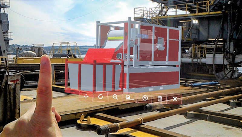
The first step in realizing this new “reality” is the use of a single hard hat-mounted Microsoft HoloLens, equipped with the augmented and virtual reality solutions software applications, Fig. 1. A non-specialist user already resident on the rig can use the technology to digitally overlay precise, as-built 1:1 scale models of equipment onto the existing physical rig spaces, using the Imersiv holographic model viewer.
A proprietary conversion methodology that eliminates extraneous geometry from as-built 3D models without loss of resolution ensures that 3D holographic object files load rapidly and can be manipulated with ease. The efficiency in file conversion also ensures that an extensive inventory of equipment can be resident on the device, eliminating the challenge of operation in limited- or zero-bandwidth environments common to the offshore environment.
The application is accessed either through voice or gesture via a customized user interface. The Microsoft HoloLens has the capability to interpret more than 25 discrete hand movements; users can achieve precise object manipulation in three dimensions while virtually measuring all clearances to help ensure optimal placement. The user also can record photos, videos and audio, via onboard PoV, of all real and augmented objects, and review with engineering staff or operator management.
Concurrently, using the rapid wide-area scan (RWAS) function in the Imersiv virtual mapping, the user can complete a 1-cm resolution scan of the respective rig space and access routes for later modeling and simulation, Fig. 2. Where once a specialized third-party team would be required to transport expensive and complex laser scanning hardware to the rig, now a single rig worker can generate a similar result as part of a regular routine, with only a simple task order.
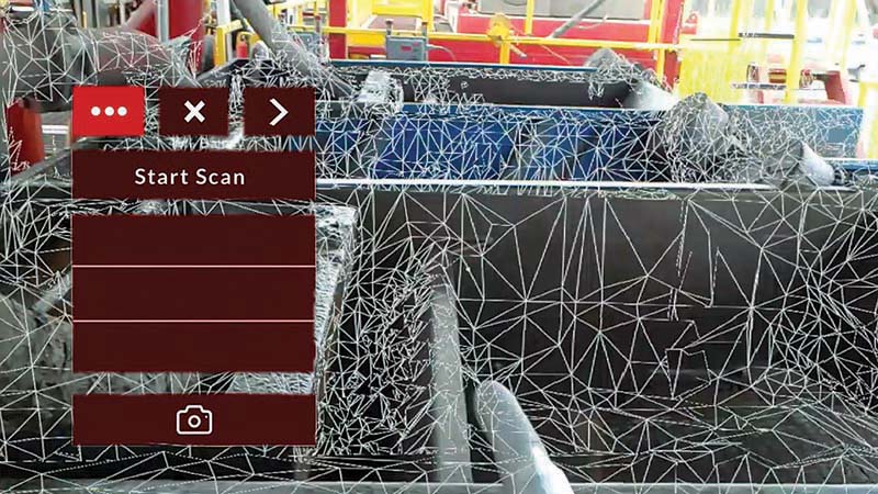
Imersiv virtual mapping is based on a proprietary methodology that harnesses the Microsoft HoloLens native spatial location function of continuously and automatically scanning its surroundings within the user’s field-of-view (FoV). The application allows the user to activate and control this native function to create a multi-polygonal mesh that is saved at an optimized resolution of 1,200 polygons per square meter.
Scans of average rig spaces require 120 to 150 MB of storage, which is well under the 64 GB of internal storage capacity of the device, ensuring everything can be done offline. During the optimization process, the .ROOM file is first converted to a point cloud format and then modeled into optimized 3D content, using both automatic and manual means, then exported in .FBX file format. The end-results are textured 3D renderings of the scanned rig space, which can be integrated with product-specific 3D objects to create an exact visual representation of the proposed installation location, complete with 3D renderings of the equipment itself.
CASE STUDIES
Over the last 12 months, the company has tested and commercially deployed Imersiv AR/VR Solutions in the U.S. and UK, to onshore and offshore rigs.
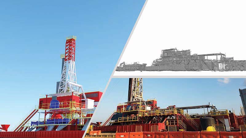
Augmented reality enables faster decision-making. At two offshore rigs, located quayside in the UK, Imersiv AR/VR solutions were deployed to assess the potential for installation of a solids control suite and a swarf separation unit. The exercise delivered complete scans of the degassing and shaker area, cementing power unit, cementing pump unit, auger balcony, and the pipe deck. The AR/VR technology generated a 3D holographic model representation of the rigsite and equipment, capturing precise and detailed measurements and an accurate representation of the area, Fig. 3.
Using the Microsoft Hololens, the rigsite specialist scanned the area for a total of five hours. Using the Imersiv holographic model viewer, the user was able to rapidly assess location suitability, measure safety and maintenance clearances, and record PoV video and audio comments for use by the BaraSolve engineering team in less than 60 min. Next, it took 1 hr to extract the scan and produce an AR- and VR-ready raw mesh, and 4 hr to process the results into a fully immersive VR-ready model. Since the scanning was conducted by a field technician, this jackup deployment proved that even personnel with minimal equipment familiarization can easily produce a functional scan of the rig environment and quickly create accurate 3D VR models of the space.
The ability to place equipment in a 3D holograph at the rigsite was a major differentiator for the operator. The required equipment was placed on a 1:1 scale from a library of 3D models. With the 3D hologram anchored to a location, the technician was able to walk around the equipment and gain a real-life experience of what it would look like. While wearing the headset, a user can identify any potential conflicts and simulate the lift/placing of equipment, providing greater confidence prior to placing the physical equipment. In addition, the technician took pictures and videos to share with engineers in the office, allowing for real-time decision making, saving the operator time and money while increasing operational efficiency.
Onshore capabilities. In Texas, personnel successfully scanned the solids control suite, drilling rig floor, drilling solids treatment system, power unit, mud system, solids discharge, BOP, and rig ground-level infrastructure over a period of 4 hr, Fig. 4. From the scan, a raw mesh was created and optimized to produce both an AR- and VR-ready model of the solids control suite and land spread. Through collaboration with the operator, placement of the new thermal-based mud reclamation system was optimized in real time, enabling faster decision-making.
VALUE ADDED
The Imersiv Augmented and Virtual Reality Solutions empower non-technical rig personnel, while improving operational efficiency, precision and communication. The unique combination of Imersiv AR/VR technologies enhances collaboration between service providers and operators while creating confidence that the optimal system design can be delivered and installed efficiently with fewer iterations and missteps. The technology decreases overall execution time, while reducing costs and maximizing asset value.
REFERENCES
- Kunkel, Nelson, and Steve Soechtig, 207 Mixed Reality, Tech Trends 2017: The kinetic enterprise, Deloitte University press, p. 49.
- Virtual Reality Society, UK. https://www.vrs.org.uk/virtual-reality/what-is-virtual-reality.html

- Late-life field management: Repair, repurposing and obsolescence management support sustainable well integrity (June)
- Shifting from calendar to usage-based maintenance: Proven results that demand your attention (June)
- Enhancing Lower Tertiary recovery and profitability: The options – Part 2 (May)
- Executive viewpoint: Methane monitoring goes digital (May)
- Drilling technology: Optimizing high-pressure pump performance with fluid end advances (May)
- John Henry vs the steam drill: Will the robots win? (May)
- Subsea technology- Corrosion monitoring: From failure to success (February 2024)
- Applying ultra-deep LWD resistivity technology successfully in a SAGD operation (May 2019)
- Adoption of wireless intelligent completions advances (May 2019)
- Majors double down as takeaway crunch eases (April 2019)
- What’s new in well logging and formation evaluation (April 2019)
- Qualification of a 20,000-psi subsea BOP: A collaborative approach (February 2019)

