What's happening in exploration
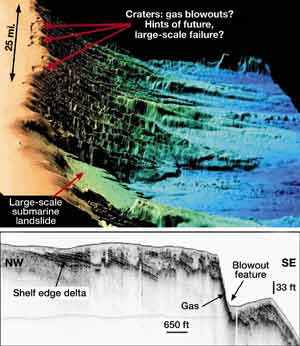
Strange craters discovered off U.S. mid-Atlantic coastScientists made a puzzling discovery while investigating tsunami-causing mechanisms along the U.S. mid-Atlantic outer continental shelf. The area was thought to be filled with large, en echelon-aligned cracks along a 25-mi section of the OCS from north of Cape Hatteras to southern Virginia. The shelf edge is located in 300- to 600-ft waters between the Norfolk Canyon and the Albemarle-Currituck submarine slide, which occurred 16,000 to 18,000 years ago. However, a recent Woods Hole Oceanographic Institution cruise gathered more than 1,250 mi of geophysical data using a combination sub-bottom profiler and sidescan sonar towfish, as well as sediment core samples from several locations taken with a gravity core tool. The data showed that the cracks were actually craters.
Based on preliminary results, the scientists said that the craters are a system of large depressions along the shelf edge which appear to have been excavated by gas erupting through the seafloor. Some of the craters are as large as 4,900 ft across, 165 ft deep and up to 16,400 ft long. It suggests that there is some geological mechanism at work underneath the features, or their trend and shapes might be due to proximity to the shelf edge. "We don’t know the source of the gas," team leader Neal Driscoll said. "But it is clear that gas played an important role in forming these features." Seismic data in the form of bright spots show that gas is pervasive in and around the blowouts. Much more work is needed before definitive statements can be made, but the speculation is that layers of relatively impermeable sediment draped over the edge of the shelf to form a gas trap. Pressure builds until the seafloor explodes, presumably throwing sediment into the water column, where it is carried away by bottom currents. Jeffrey Weissel of Columbia University’s Lamont-Doherty Earth Observatory said, "The apparent size and violence of the gas-release episodes does concern us, as they could pose hazards in and of themselves. Shallow gas blowouts have damaged or destroyed oil drilling rigs in the Gulf of Mexico and the North Sea – something we should keep in mind when future work is conducted here." SEG meeting. SEG’s Seventieth Annual Meeting in Calgary was another success. Attendance was down about 20% compared to previous Houston or New Orleans meetings, probably due to less local participation. Also, Monday, the first day of the show, was a provincial holiday in Alberta. There was no lack of technical papers: 550 oral and 90 poster presentations were delivered from a record 715 submissions. Exhibitors numbered over 275. The only consistently heard complaint was that the technical and vendor areas were held in widely separated areas. Everything else was great, and the mood was upbeat. Next year, the show will be held in San Antonio – a superb place to hold a convention. Everything is within easy walking distance: exhibitors’ area, hotels and nightlife; you probably won’t need a car. Don’t miss this one. Register early. Magical startup. Geoscientists and asset teams at Texaco have been using the company’s proprietary Geoprobe software for fast display and integration of large datasets for the past three years. In January of this year, Michael J. Zeitlin – who led the software-development team at Texaco – formed Houston-based Magic Earth, an independent company 25% owned by Texaco. In April, Magic Earth partnered with Rock Solid Images, maker of ATTRIB3D software, to leverage synergies through integration and joint marketing of the companies’ key software products. The software has undergone several upgrades. It transforms large seismic datasets, well logs and other related data into 3-D images of potential prospects. It also allows borehole calibration of seismic volumes for predictions of lithology, porosity and fluids between wells. The aim of the technology is to reduce cycle time in 3-D interpretation and to improve exploration and production evaluations, as well as drilling programs. Marathon signed an agreement in June for Magic Earth’s high-end volume visualization / interpretation technology and related services, followed by BP Amoco in August. Also that month, Mitsubishi International Corp. bought a minority share of the company, the amount of which was not disclosed. By any measure, this new visualization / software company has soared in its
first eight months.
|

- Applying ultra-deep LWD resistivity technology successfully in a SAGD operation (May 2019)
- Adoption of wireless intelligent completions advances (May 2019)
- Majors double down as takeaway crunch eases (April 2019)
- What’s new in well logging and formation evaluation (April 2019)
- Qualification of a 20,000-psi subsea BOP: A collaborative approach (February 2019)
- ConocoPhillips’ Greg Leveille sees rapid trajectory of technical advancement continuing (February 2019)

