Active hydrocarbon system in Namibia exceeding expectations, Frontier says
The Board of Frontier, the privately held Houston-based international gas exploration company with a focus on Southern Africa, said its activities in Namibia are continuing to exceed expectations.
Frontier’s Blocks 1723, 1724 and 1823 are in the Caprivi Basin in Northern Namibia covering an area of approximately 6,427 square kilometers (2,481 square miles). A two-year Reconnaissance license was granted on July 1, 2019. Frontier has a strategic relationship with local company Gondwana Petroleum to provide technical services and act as operator for the project.

Since the issuance of the license Frontier and its partners have gathered all available geological, geophysical, geochemical and potential field data pertinent to the Blocks.
The Company has recently completed the interpretation of a gravity and magnetic survey over the acreage.
Datasets used in the study consisted of:
- high resolution magnetic data (200m line spacing).
- regional aerogravity data
- topographic maps
- digital geologic maps and published articles.
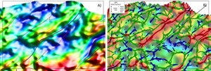
Interpretation of high-resolution magnetic data has revealed several deep-seated basement structures and helps to constrain the results obtained previously form existing aerogravity data.
This new information improves the Board’s understanding of the geologic evolution of the basin and will serve as a guide to optimally locate the focus areas of the continuing exploration program which may include a geochemical soil gas survey followed by the acquisition of 2D seismic data.
High-Resolution magnetic data processing indicating a deep sedimentary basin within the license area. A) Upward continuation at 3km with interpreted structures. B) Depth to basement from SPI algorithm.
The area has become a primary target in the region for natural gas as a source for power generation with the recent announcement on the discovery of over of 660 feet (200m) of oil and gas shows in a well drilled in the nearby Kavango Basin. This well penetrated several zones containing porous and permeable sediments. The data proves the existence of an active hydrocarbon system with possible multiple source intervals. In addition, the analysis of mud gas shows during the drilling operation identified a high BTU (British Thermal Unit) gas in numerous cutting samples.
“The recent announcement of the presence of an active hydrocarbon system in the area is very exciting for all those involved in gas exploration in this region,” said Jack Keyes, Frontier’s CEO. “We look forward to plan the next phase of our exploration activity.”


