Gyro-while-drilling technology improves drilling efficiency and well placement
While the earliest forms of surveys using a gyro date back almost a century, it wasn’t until the mid-1980s that gyroscopic surveys, as the energy industry now knows them, were broadly adopted. Work with operators on years of field trials, which culminated in sensor ruggedization and accuracy improvements, saw the release of the first system by Gyrodata in the early 1980s. Subsequent advances over the next decade saw the company develop and release a gyroscopic steering tool and the industry’s first drop gyroscopic surveying system. As wellbore construction requirements were changing, the need to pioneer a new type of drilling service became apparent. With the development and release of the GyroGuide gyro-while-drilling (GWD) system in the early 2000s, a step-change came in the form of real-time gyro steering and surveying-while-drilling.
DEVELOPMENT
The GyroGuide GWD system has evolved to collect real-time survey data at all inclinations and in any direction, which enables safer operations and more accurate wellbore positioning. The modular gyro tool is combined with a host measurement-while-drilling (MWD) and telemetry system, allowing gyroscopic surveys in various applications. Gyro accuracy ensures precise wellbore guidance for collision avoidance, with the GWD tool providing continuous inclination and toolface from vertical while sliding and full surveys on demand. While traditional systems struggle with magnetic interference, in this setup, the sensors can be run closer to the bit in the bottomhole assembly (BHA). This eliminates the need for non-magnetic spacing collars for the gyro sensor.
Using a GWD service also eliminates the need to use wireline gyros to orient or steer the drilling assemblies, which increases safety and decreases rig time. The highest planned inclination of the survey is used to choose the tool, with Gyrodata offering three options where maximum inclination capability corresponds with the tool name: GWD40, GWD70, and GWD90. Selecting the proper tool is done by determining whether it will be used in a vertical, low-inclination, high-angle, or horizontal application. The drilling plan, well type, and additional technologies included in the well plan should be also considered. Regardless of the tool chosen, it can be run with most commonly available MWD systems. The most advanced system, the GWD90, uses CAP data processing to correct g-sensitive errors in real time and provides transparent quality control of gravity, full earth rate, and latitude. The system also has memory multi-shot capability, as the BHA is tripped out of hole.
CASE HISTORIES

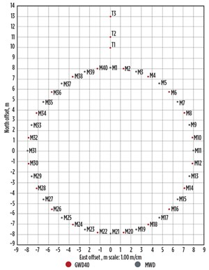
In Poland, an operator was drilling a challenging ring of 40 wells at an operational coal mine, Fig. 1. The objective of the campaign was to sink a new shaft while avoiding a cave-in from the drilling activities. This would be difficult, due to the complicated nature of the plan and fragile geological conditions in the area. The operator needed to conduct this drilling campaign with pinpoint accuracy and precision, so as not to risk the integrity of the existing mine. The operation required drilling 40 wells in a circular pattern, each to a TD of approximately 490 m, and freezing them, which would allow the shaft to be dug within the circle. This “freeze ring” of vertical wells would have a minimum spacing between each well of 1.5 m from neighboring wells at TD. Because traditional MWD solutions would experience magnetic interference due to the extreme proximity of the wells, the operator elected to utilize the GWD40 for every second well in the circle.
As this was a price-sensitive project, the operator needed a solution that would allow them to achieve their objectives in the most cost-efficient manner. The GWD40 procedures required 50% fewer people on-site versus a single-shot wireline gyro run, and the two rigs drilling the wells were able to work concurrently. Because there were five GWD tools onsite, the operator was able to establish a pattern of testing tools from previous runs while other tools were drilling subsequent wells. This reduced the time necessary to run and service multiple tools and kept everything on-schedule, per the operator’s request to keep rig time to a minimum. Using the GWD40 system saved substantial time versus a standard wireline-conveyed single-shot. The wells were surveyed at 6-m intervals on the first rig and 10-m intervals on the second one, with 73 surveys per well, on average, in the former and 52 in the latter. There were total of 22 wells drilled without nonproductive time (NPT). The GWD40 system saved the operator approximately $665,000, based on reducing rig time and wireline crew costs.
- A major operator was carrying out a development drilling campaign in a deepwater application offshore Brazil. The challenges of deepwater operations were exacerbated by a 2,000-m salt zone, which added considerable complexity to the drilling process. In the event of a blowout, the traditional method of using an active ranging technology to detect metal from the last casing shoe or drill pipe would not be effective due to the high resistivity of the salt. The operator required a comprehensive contingency relief well plan with a stringent survey management component. This combination was necessary to achieve the dual objectives of minimizing risk while drilling the pre-salt wells and placing them with extreme accuracy to reduce the probability of survey errors as much as possible.
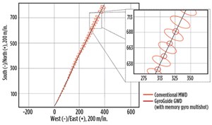
Gyrodata recommended running a GWD70 system, in conjunction with the existing directional company’s MWD system. The dual set-up, which included magnetic and gyroscopic survey sensors, would achieve all safety and contingency relief well requirements when running at the same time, while simultaneously enabling the detection of any gross errors. First, a single-depth gross error test was run to compare the difference between the two survey methods to ascertain the uncertainty specified by the tools’ error models. Second, a relative instrument performance (RIP) test was conducted with multiple surveys. The RIP test assessed the validity of the two directional surveys run in the same hole section in real time and allowed visual identification of discrepancies versus tolerances. Finally, the overlap error ellipses method was implemented, which provided additional evaluation of survey quality. Error ellipses were plotted around the well positions, as determined by the two surveys. The degree of ellipse overlap measured the surveys’ agreement.

Using GWD technology, the well was placed successfully, with improved reliability of its final position and a reduction in overall uncertainty. In this application, the GWD70 system reduced the ellipse of uncertainty (EOU) by 75%, and with the addition of a memory gyro multishot mode, up to 88% versus conventional MWD error models, Fig. 2. This provided the operator with a high level of confidence that the wellbore was placed correctly, which was crucial in mitigating risk and minimizing response time to deal with an incident.
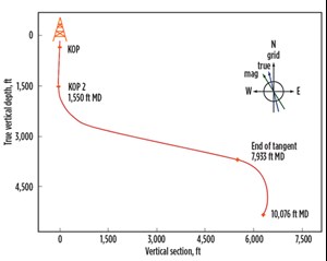
- An international E&P company was planning to drill a 10,000-ft, 8½-in. hole section in a field offshore Thailand. The lithology of the field, which included Oligocene to Miocene lacustrine and fluvial sandstones, meant the operator had to explore for oil deposits that were embedded in thinly stacked sand layers. As a multitude of other wells had already been drilled in the area and wellbore conditions were fragile, the well plan required an S-shaped well profile with a tangent section covering more than 3,700 ft at an inclination of 78°, Fig. 3.

The complexity of the well plan meant special consideration was required to keep magnetic interference from corrupting the magnetic survey readings, as well as to mitigate the risk of wellbore collision during drilling operations. The operator required a highly accurate, real-time survey solution that could be integrated with an advanced rotary steerable system (RSS) in the BHA to increase confidence in precise wellbore placement.
The operator chose a GWD90 system to be run in combination with a third-party RSS. The GWD90 system uses two gyro sensors to survey when wellbore inclination exceeds 70°, while simultaneously running with an MWD magnetic sensor. This set-up improves survey accuracy and gross error detection while allowing more reliable, real-time measurement. Gyrodata and the RSS provider worked together to source a unique GWD collar for the GWD and RSS combination in a tight timeframe of only two weeks.
After assembling the BHA, the system was run for the length of the section, providing real-time surveys to a TD of 8,945 ft and a measured depth of 10,076 ft in one run. The GWD90 system surveyed to a maximum inclination of 78° in the 3,780-ft tangent section. The combined GWD and RSS system eliminated the need for wireline gyro surveys and related delays from on-surface interruptions, which resulted in substantial improvements to well delivery time and reductions in drilling costs. The project was the first drilling application in Thailand combining the GWD90 with an RSS, highlighting the potential for additional work in the area.
EVOLUTION
While traditional GWD will continue to be relevant, the future of this technology is in solid-state GWD. Solid-state GWD was developed in response to the energy industry’s demand for even greater wellbore placement accuracy, with complex 3D well plans and hydraulic fracturing necessitating a more advanced, more rugged system for today’s wells. Gyrodata recently introduced the Quest GWD system powered by SPEAR, a solid-state gyroscopic tool with a sensor package that precisely determines the earth’s rotational rate, inclination, azimuth, and well orientation. Using this new technology reduces EOU in real time significantly when compared to traditional systems. Additionally, because the system has no moving parts, it does not require the time typically necessary to spin-up the gyro and achieve temperature stability. This means the system can be deployed sooner, and the time to survey is significantly reduced.
The value of using these advanced GWD systems can be distilled effectively into several major points.
- Running solid-state GWD technology directly reduces the amount of rig time necessary for drilling and surveying over traditional solutions.
- The improvements made to the new GWD systems have made avoiding wellbore collision via accurate well placement simpler than ever before. With an increase in issues such as frac hits and complicated parent/child well interactions, avoiding drilling into adjacent wells is critical to operational efficiency and safety.
- The new systems enable the operator to place the wellbore precisely into the hydrocarbon-rich production zone, potentially improving hydrocarbon recovery. This is critical from an economic standpoint, especially in applications where high initial production rates can quickly give way to reduced expected ultimate recovery.
As the market continues to evolve, adapting to changes and continuing to innovate will be a defining KPI for companies in the OFS sector. Moving forward, gyros will see even greater adoption to meet increasingly difficult wellbore placement requirements in a multitude of worldwide applications.
- Coiled tubing drilling’s role in the energy transition (March 2024)
- Digital tool kit enhances real-time decision-making to improve drilling efficiency and performance (February 2024)
- E&P outside the U.S. maintains a disciplined pace (February 2024)
- U.S. operators reduce activity as crude prices plunge (February 2024)
- Drilling advances (January 2024)
- Driving MPD adoption with performance-enhancing technologies (January 2024)


