G&G integration enhances acquisition of multi-client studies offshore Gabon
The deepwater area of the Gabon South basin is one of the last underexplored areas of the West Africa Atlantic Margin. CGG is acquiring and imaging a large broadband, multi-client 3D survey, covering over 25,000 km2 in this area, which will form the cornerstone of a major, integrated G&G study of the region.
Multi-client surveys provide a cost-effective means of acquiring high-quality data. Costs can be shared, and larger surveys acquired, for a better overall view of the prospectivity than is generally the case with smaller, proprietary surveys. Access to large surveys, in both mature and virgin areas, allows companies to reduce their exploration risk. It also helps to cut the time between the awarding of a license and the drilling of the first well.
Postage-stamp-size surveys often leave holes in the data coverage, are inefficient due to the disproportionate time spent on line turns, and have different acquisition parameters and azimuths, making regional exploration more challenging. They also are more expensive to acquire, because each survey requires its own migration aperture, which can double the acquisition footprint, as compared to the fully migrated final volume.
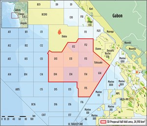
As an integrated geoscience company, CGG provides more than seismic data packages for its multi-client surveys. In the program being acquired in the South Gabon basin (Fig. 1), a comprehensive, fully integrated geoscience package will be delivered. This package will include regional geological analysis to take in source, reservoir and seal rock distribution, data on potential fields, satellite imagery, detailed analysis of key wells and seismic interpretation, in addition to high-quality seismic data.
The integration of geological knowledge, well and gravity data with the seismic data, combined with advanced reservoir imaging technology, including extensive QC via AVO tools, will ensure delivery of a high-quality, reservoir-oriented, broad-bandwidth data volume that has been imaged and QC’ed for reservoir characterization and analysis. The goal is to reduce the time spent by exploration companies on the conditioning and integration of data, and allow more time to be spent on the identification of new prospects and play models.
CGG has a long history in Gabon and has developed a good relationship with Direction Générale des Hydrocarbures (DGH). CGG worked with DGH in an advisory role, in the promotion of the deepwater open acreage offered as part of the 10th Licence Round in 2010. CGG acquired the original 2D seismic data, focused on sub-salt imaging in the whole of Gabon’s deepwater offshore sector, as well as the 1999 Astrid-Anton 3D survey, which is being overshot by the new 3D BroadSeis data.
GEOLOGICAL OVERVIEW
Interest in this area, and other deepwater pre-salt plays offshore southwestern Africa, has been renewed following the success of exploration in the South Atlantic conjugate margin in Brazil, as well as major discoveries offshore Angola. Recent discoveries also have been made in the vicinity of the new survey area, such as Eni’s large pre-salt discoveries, Nene and Minsala, offshore Congo, 80 km to the east of the new survey area.
Nene was discovered in 2012, and Minsala was found in 2014. Each one contains over 1.0 Bbbl of oil and is found in a water depth of less than 100 m. Just a few
kilometers northeast of the open acreage, in water depths of 200 m to 300 m, in the Dussafu Block, Harvest struck the Ruche discovery in 2011, and the Tortue find in 2013. Each of these discoveries contains several tens of million barrels of oil in the Dentale (pre-salt) formation. In 2013, Total hit the Diaman gas and condensate discovery, in a 1,700-m water depth on the Diaba Block. Finally, in 2014, Shell’s Leopard gas discovery was made in Block BCD-10, at a water depth of 2,100 m.
All of these recent pre-salt discoveries surround CGG’s new multi-client survey area. Only three wells have been drilled within the survey area; however, none of them penetrated the salt to test pre-salt reservoirs. The recent deepwater hydrocarbon finds appear to be gassier than the earlier oil discoveries. The distribution of potential hydrocarbon phases, within the pre-salt basin, is one of the items that, hopefully, the new study will help to explain.
Exploration targets range from deep, sub-salt Barremian to Aptian sandstones, with high porosity and permeability, through to supra-salt Albian-age Madiela carbonate turtlebacks, which can provide good reservoirs locally, and Cretaceous-Tertiary turbidite sands that constitute well-known objectives further south in the waters of Angola and Congo. The most important source rocks are the Neocomian to Aptian shales, of the Melania and Kissenda formations, in the South Gabon sub-basin. Both are organic-rich, oil-prone, lacustrine deposits.
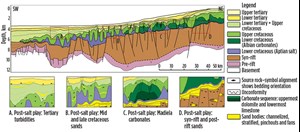
Pre-salt traps comprise tilted fault blocks and transpressive structures sealed by shales or salt. These pre-salt structures in the South Gabon sub-basin have proved difficult to resolve on existing 2D seismic data. However, they are clearly imaged, even on very early brute stacks from the new 3D BroadSeis data. Post-salt traps comprise drapes over salt domes sealed by shales or combination structural/stratigraphic traps of sand-rich channels within turbidite systems. Good Cretaceous and Tertiary source rocks are present along the margin, but their maturity still needs to be proved in the deep offshore area. Figure 2 depicts a cross-section through the Gabon South basin, and the various play concepts.
CGG Robertson has recently undertaken a regional geological study, extending from the Niger Delta to the mouth of the Congo, which has collated potential field data, legacy seismic, structural, geochemical, biostratigraphic and sedimentological information into a suite of palaeogeographic reconstructions. These reconstructions have provided a new view on basin development, through time, in the South Gabon area. The changes in basin hydrology that accompanied the shift from freshwater lacustrine systems, in the syn-rift, to evaporite deposition that accompanied the onset of marine incursions, carries important implications for the distribution of source and reservoir facies in the pre-salt of South Gabon. This study will be extended—and improved—when the new BroadSeis dataset is available.
SURVEY DESIGN
Combined with CGG’s previous experience in the area, this geological insight has given the company a clear perspective for planning the seismic survey. Using existing velocity and density models, CGG performed wave equation modeling to determine the optimal acquisition parameters, in terms of offset and bin size, for the survey.
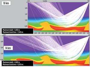
Cones of rays at 30°, 40° and 50° angles were shot from different pre-salt locations and depths, and used to map surface offset coverage. A 10-km-offset range was found to be sufficient for angles up to 40° and most targets, but there was some benefit from longer offsets (up to 14 km) for larger reflection angles and deeper targets. To investigate this further, diving waves were analyzed for 10-km and 14-km maximum offsets. Based on the synthetic velocity model, the longer offsets were not found to be of great benefit to full waveform inversion (FWI) work, as the diving rays did not penetrate any deeper into the model, but just gave more coverage to the shallow data, Fig. 3.
Acoustic finite-difference modeling was used to generate synthetic shots (up to 14-km offset), which were then migrated with 2D reverse time migration (RTM), using the true velocity model. The RTM output gathers were found to be slightly improved in the 40°-to-50° angle range, when using longer offsets in some areas, but below 40°, there was little difference. From these analyses, it was considered that 10-km streamers were sufficient for pre-salt imaging for most of the area, although longer offsets were acquired over a smaller area for a single, specific deep target.
A further set of tests was performed to investigate the optimum crossline bin size for the survey, to deliver maximum operational efficiency without compromising data quality. A crossline bin width of 30 m was considered to provide the optimum size. To achieve the low frequencies necessary for penetrating to the pre-salt target, as well as the high frequencies required for detailed imaging of the post-salt, broadband data were acquired, using the BroadSeis variable-depth streamer solution.
The variability of the streamer depth and the shape of the cable were tuned for the water depth and targets, so that the notch diversity and output spectra were optimized for the survey. By combining the results of CGG’s detailed modeling and analysis with information from the company’s clients and the geological expertise of CGG’s GeoConsulting team, it was possible to design optimum acquisition parameters for the survey, to acquire the correct data for imaging the target. Combining advanced subsurface imaging technologies, customized for the local geology, with reservoir-oriented QC ensures the highest-quality seismic images, as well as a data volume already pre-conditioned for use in reservoir characterization and analysis.
ACQUISITION
The survey is being undertaken by two vessels, the Geo Caribbean and the Oceanic Endeavour, each towing 10 x 10-km streamers, at 120-m separation. To complete the acquisition of the survey this summer, the vessels will acquire data simultaneously. BroadSeis capitalizes on the low-noise characteristics of Sercel Sentinel, solid foam-filled streamers, which have been proven to be 10–15 dB quieter than gel streamers below 10 Hz in vibration tank tests.1 The proprietary streamer shape enables the majority of the streamer to be towed deep, down to 50 m.
This deep tow enables the recording of the ultra-low frequencies required for pre-salt imaging; it also avoids much of the sea-state noise, thereby extending the weather window for greater operational efficiency and faster turnaround times. The ultra-low frequencies achieved using the BroadSeis solution provide better penetration through complex overburdens, improved signal-to-noise ratios for deeper targets, and more quantitative seismic inversion. The enhanced layer differentiation, with improved texture and character, makes interpretation more straightforward, as it is easier to correlate packages across faults etc., Fig. 4.
The vessels are being employed simultaneously by means of CGG’s SynAcq, synchronized acquisition technique, in which both vessels work semi-independently, but make use of advanced navigation tools that allow the planning and management of seismic interference (SI or noise contamination from the nearby vessel shots), so as to avoid any interference that cannot be readily attenuated in processing. The success of this strategy in the North Sea has led to it being applied more widely, to acquire as much data as possible, as fast as possible, without compromising data quality. In the deep waters of the Gabon survey area, SI is much less of a problem than in the shallow waters of the North Sea, but the same strategy is being employed to ensure high-quality data are uncompromised by any hard-to-remove SI.
In the shot domain, SI tends to be coherent, dispersive and fairly linear. When sorted away from shot order, it tends to be incoherent, random and intermittent, and can then be attenuated with multi-dimensional impulsive denoise tools. Such a technique is efficient, as long as SI is not synchronous from shot to shot. This can be ensured through proper acquisition planning and preventive actions, such as the adjustment of the vessel speeds when they are passing near each other. Onboard processing tests ensure that any SI contamination can be removed without damaging the primary data.2 This combination, of planned acquisition and processing, enables the vessels to work as close as 20 km apart, and the data to be acquired in half the time, without degrading data quality. As both vessels use a conventional spread, there is no loss of near offsets (and therefore shallow coverage) that would come from using an extra-wide streamer spread to reduce acquisition time.
One of the participating clients has requested that a 2,500-km2 area of the survey be acquired with longer offsets, of up to 15.5 km. To accommodate this request, the area is being overshot, using the same receiver spread, but with an additional source boat sailing ahead of the streamer vessel. This technique is just one item in a toolbox of tailored acquisition techniques that have been developed to enable acquisition of any desired geometry.
SUBSURFACE IMAGING
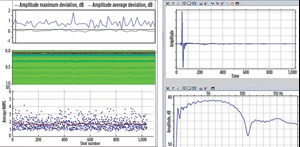
This survey also employs the newly developed, proprietary onboard system to generate accurate far-field signatures from the recorded near-field hydrophone data.3,4,5 This approach has proved to deliver a better estimate of the bubble and the low-frequency signal (as compared to conventional pressure field modeling), which are essential elements of broadband acquisition. It enables accurate designature throughout the bandwidth, encompassing de-bubbling and zero-phasing in the same step. This system is also used to monitor the derived far-field signature for every shot in the field, as an aid to acquisition quality control and to ensure a stable signature, Fig. 5.
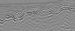
This accurate source designature and zero-phasing is complemented by CGG’s 3D deghosting technique, which uses a progressive sparse Tau-Px-Py inversion to ensure ghosts are correctly handled in areas of complex geology, and so delivers the sharpest possible broadband wavelets.6 A very early-stage seismic section, with minimal testing of parameters and velocities from old sparse 2D data, (Fig. 6) gives an indication of the data quality to be expected.
The full production data are going through a comprehensive reservoir-oriented processing QC workflow, to ensure that the final delivered data have been thoroughly QC’ed for stable and accurate phase and amplitudes. CGG’s goal is to provide a final data volume that requires minimal pre-conditioning prior to processes, such as elastic inversion and reservoir characterization studies. In this workflow, we migrate data at various key stages to look at the evolution of well ties, wavelet stability and AVO compliance, etc. Information from the available wells is being integrated, and maps of
relevant QC products, following horizons, will show spatial variations and conformity with known geological information.
Gravity data were acquired simultaneously with the seismic data for the entire survey area, and interpretation of these data is being used to derive a depth-to-basement map to analyze the basin’s deep structure. This information, and the initial seismic interpretation, are being used to generate models of the salt and carbonates. CGG’s TomoML multi-layer tomography velocity model building is then constrained by the gravity model. Full waveform inversion, capitalizing on the ultra-low frequencies delivered by BroadSeis, will be used to generate the velocity model for the shallow sedimentary package. This final RTM (pre-stack reverse time depth migration) seismic dataset is expected to be completed by the middle of 2016, but a fast-track, pre-stack time migration (PSTM) dataset of the full area will be available in September 2015.
CONCLUSION
The final seismic dataset will be only part of the eventual, fully integrated G&G package, which will involve all of CGG’s geoscience divisions and include:
- Analysis of key wells from the area, especially those drilled to the pre-salt Lower Cretaceous section
- Interpretation of the gravity data acquired with the seismic data to derive a depth-to-basement map for analysis of the basin’s deep structure
- Full seismic interpretation in the depth domain to identify the main prospective areas pre- and post-salt.
- Integrated analysis of satellite seep data with the shallow seismic features, to identify potential, natural hydrocarbon escape conduits
- Production of paleogeographic maps of the area
- Production of source rock and reservoir distribution maps
- Production of a 3D basin model and generation of source rock maturity maps.
Currently, very little is known about the source rock and reservoir distribution in this area, but early seismic imaging results indicate the presence of thick syn-rift and sag sequences below the salt, which are key intervals of the pre-salt petroleum system. The broad bandwidths, and exceptional low-noise low frequencies delivered by BroadSeis, with its proprietary deghosting and imaging technology, have produced excellent pre-salt imaging in previous Atlantic margin surveys, offshore both Brazil and Angola. Early results from this survey in Gabon show the same promise.
It is believed that this project represents the future of multi-client seismic surveys—extensive, detailed, integrated and cost-effective. The final package will deliver an unprecedented array of state-of-the-art integrated geoscience data in an easily accessible form, which can be used directly for exploration; play evaluation; well location optimization; geohazard identification and reservoir delineation; characterization; and modeling. The combination of the best images of the subsurface with value-added geoscience products can help improve recovery and reduce risks/costs. ![]()
ACKNOWLEDGEMENTS
The authors would like to thank CGG Multi-Client & New Ventures for permission to publish this article. Images courtesy of CGG Multi-Client.
REFERENCES
- Dowle, R., “Solid streamer noise reduction principles,” SEG Expanded Abstracts 25, pp. 85–89, 2006.
- Elboth, T., “A seismic interference noise experiment in the central North Sea,” EAGE Conference and Exhibition, Madrid, June 1–4, 2015.
- Ziolkowski, A., G. E. Parkes, L. Hatton and T. Haugland, “The signature of an airgun array: Computation from near-field measurements, including interactions,” Geophysics, 47, pp. 1,413–1,421, 1982.
- Poole, G., “Pre-migration receiver de-ghosting and re-datuming for variable depth streamer data,” SEG Technical Program Expanded Abstracts, pp. 4,216–4,220, 2013.
- Ni, Y., T. Payen and A. Vesin, “Joint inversion of near-field and far-field hydrophone data for source signature estimation,” SEG Technical Program Expanded Abstracts, pp. 57–61, 2014.
- Wu, Q., C. Lee, W. Zhao, P. Wang and Y. Li, “3D deghosting for full-azimuth and ultra-long offset marine data,” SEG Technical Program Expanded Abstracts, pp. 4,238–4,242, 2014.
- Advancing offshore decarbonization through electrification of FPSOs (March 2024)
- Subsea technology- Corrosion monitoring: From failure to success (February 2024)
- Driving MPD adoption with performance-enhancing technologies (January 2024)
- Digital transformation: A breakthrough year for digitalization in the offshore sector (January 2024)
- Quantum computing and subsurface prediction (January 2024)
- Offshore technology: Platform design: Is the next generation of offshore platforms changing offshore energy? (December 2023)
- Applying ultra-deep LWD resistivity technology successfully in a SAGD operation (May 2019)
- Adoption of wireless intelligent completions advances (May 2019)
- Majors double down as takeaway crunch eases (April 2019)
- What’s new in well logging and formation evaluation (April 2019)
- Qualification of a 20,000-psi subsea BOP: A collaborative approach (February 2019)
- ConocoPhillips’ Greg Leveille sees rapid trajectory of technical advancement continuing (February 2019)

