What's new in exploration
Turning perceived failures into successes
|
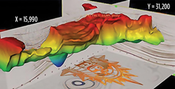
While money chases where oil flows, explorationists are busy looking where they think oil will flow, often where everyone else always knows it will not. I lived in Buenos Aires for a while, performing exploration in the Neuquén and Chaco basins, and also looking at new ventures across the South American continent.
Our oil company looked at the Falklands as a place to explore, or at least we discussed it. Early 2D seismic showed astounding structures. I was interested, until a PhD company geologist explained to me, rather guru-like, and insisted that the Malvinas complex was late to “drift,” leaving from Africa to Patagonia, being out at sea and missing all that Cretaceous flora that make up most of the world’s source rock. I questioned that, since a great deal of Patagonia is producing oil. He countered that the post-breakup paleo land masses were moving west, with no known dinosaurs and what-not, until they collided with today’s Andes Mountains. Obviously, the folks at Rockhopper Exploration must not have read any of his material. What’s (not) new. Is another down cycle in the works? I hear that some exploration companies are thinking of slowing down their expenditures—results are not as desired, etc. Prices are okay, the value of the dollar is up, my feet hurt, and so on. Besides all the handwringing about lawyers or accountants in charge of oil, what really is happening, is a dearth of new people coming into our industry. This is not new either, but it now has become alarmingly serious. We have technology projects working on intelligent BOPs, intelligent cement, neural interpretation of 3D seismic, and intelligent deepwater risers. Now, all we need are more intelligent people. However, seismic companies tell me they are anticipating a slowdown that may result in layoffs. Unfortunately, this is all too familiar in our industry. Will technology save the manpower drain? Not really. MANAGEMENT: How comfortable do you feel when your IT people are on vacation? Between Marxist Ukraine events and the rising Islamist Empire gaining more oil fields almost every week, more production leaves the market daily. Fortunately, those political forces have yet to gain a foothold in either Argentina or the Permian basin of Texas. Maybe we should continue to find new resources a while longer? What’s new in technology? Semblance auto picking, then and now: If you thought innovations from black-and-white film to color were cool, look at visualization today—3D visualization is available on your PC within several interpretation packages. You do not need an expensive workstation anymore, or a mortgage to buy software. 3D visualization is no longer in some theatre with glasses! The horizon shown on the SEAM illustration on this page is an auto-picked interpretation made with processing software. You can get similar 3D visualization capability with quality software, such as Landmark or Geographix, Kingdom, Petrel, and with add-in apps from OpendTect. However, challengers with newer, cheaper versions are showing up for lease from such emerging winners as Drilling Info or DUG. These companies will continue to push interpretation technology the same way that PC chips have gone. That’s good. Geoscientists often get caught up in visualization tools as toys. Colors are powerful. But, they tend to hide the sameness of seismic data processing methods. We should expect everyone to claim their product is the best. Yet, it is very, very difficult for seismic and processing companies to differentiate their products, since all seismic methods are based on the same theory. That is why 40-some companies supported the SEG/SEAM/RPSEA 1 marine data program. SEAM 1 built a “perfect” set of geophysical imaging data volumes from 100%-understood geology. These data define the best that a particular method could ever produce. However, no one has ever had perfect data in the real world. The SEAM 1 data set is now available for purchase, to those who should worry about benchmarking their technical capabilities. Please do yourself a big favor, and plan to attend the annual SEG convention in Denver this month, Oct. 26-31, and walk the aisles, and attend some papers. Sit for a few outstanding vendor presentations on the latest interpretation technologies. You will notice a common methodology among everyone on just what an interpretation “is.” Way-upstream geos often forget that exploration is much more than a pretty map or a set of correlated well logs. Someone (else) will eventually drill an idea, understood from a map. I would guess that a whole lot—more than 40% of wells drilled and cataloged as a dry hole—were actually drilling and completion failures in a good reservoir. When oil companies stopped owning their own rigs and crews, they set up the push-pull between them and their drilling service companies. One wants a well, the other is being paid to make a hole in the ground, as fast as possible. There is a big difference. |


