ION has been designing and manufacturing seismic instrumentation for Arctic applications for over a quarter-century. In 2006, the company acquired its first multi-client seismic data in the Arctic. ION’s 2D BasinSPAN library now contains over 70,000 km of Arctic data that connect most of the major Arctic basins in Alaska, Canada, Greenland and Russia. BasinSPAN data is unique in terms of both lateral and vertical scales, which are optimized for the early exploration of frontier areas.
Survey parameters are designed to image geology at depths of 40 to 70 km, much deeper than traditional seismic data. Imaging at these depths aids in understanding the geologic evolution, deep basin architecture, and depositional and structural history of a petroleum system. In some areas, seismic data are complemented by over 250,000 km2 of 3D gravity and magnetics data.
Over the last eight years, ION has used its operational experience to develop a number of innovative technologies and processes that enable safe and efficient seismic data acquisition operations near, and even under, ice.
Project planning. The first step toward successful project execution in the Arctic is meticulous planning, using all available data. Although conditions can vary from year to year, metrics such as “trafficability” can be used to model the expected performance of various, multi-vessel crew configurations. During the planning phase of a recent project, several vessels were available and qualified to operate in the target survey area. Trafficability assessments were performed for various combinations of available vessels. The results indicated that operations in the northern portion of the planned survey were unlikely to be feasible for more than a few weeks, representing an unacceptable risk of project failure. However, one combination of available vessels offered the chance to extend the probable operational window to over three months. This vessel configuration was selected, and the project was subsequently successfully completed on time, and on budget, while other crews operating in similar areas were unable to complete their operations.
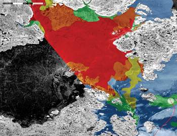
Field operations. There is no substitute for experience, and success in the Arctic will always require experienced professionals on the bridge, and in the instrument room. However, experience, alone, is not enough. Dedicated personnel also need access to the most current information, and fit-for-purpose technology. ION’s Concept Systems team developed the Narwhal ice management system in support of ION’s Arctic operations, Fig. 1. This system delivers the information necessary to operate safely, and adapt plans to accommodate ice conditions encountered in the field.
 |
| Fig. 1. Illustration of Narwhal’s ability to assist in making real-time decisions. Satellite imagery shows a trafficability analysis of go/no-go zones, based specifically on a vessel’s ice classification. |
|
Successful Arctic operations have required the development of several other unique technologies. Towing arrangements must be engineered to minimize contact between the ice and sensitive seismic instruments, while at the other end of the seismic streamer, a specialized tail buoy has been developed to minimize the risk of snagging on ice. The unstable magnetic environment at high latitudes can cause problems for the magnetic compasses used to position in-sea equipment, which has resulted in the development of a new declinometer system to measure local magnetic field variations.
Imaging. The noise created by the vessel(s) breaking ice can, in some situations, be comparable in magnitude to the energy generated by the seismic source. All seismic source energy is subject to scattering, and multiple reflections from the ice. All of these noise mechanisms must be understood and dealt with in the data processing workflow. Advanced noise attenuation techniques, radial filtering and despike all play a role in addressing the unique challenges of noise caused by diffracted energy from floating ice, breaking ice, and severe cable jerk noise from contact with ice.
As with other marine environments, multiples are also an issue. Apex-shifted de-multiple tackles off-plane multiples, and short period multiple attenuation (SPMA) addresses the challenge of difficult-to-remove shallow-water multiples.
Lastly, because of deeper towing, to minimize any potential contact of the streamers with ice, ghosts are an issue that may be solved through a processing solution. ION GXT’s WiBand solution recovers low frequencies and frequency notches from deep, towed streamer data that have been compromised by reflections from the surface.
Together, these technologies, executed in a cascaded processing flow approach, successfully overcome the geophysical challenge of removing complex noise, multiples, and ghosts unique to seismic data acquired near, and under, Arctic ice, to deliver high-resolution seismic images.
The future. The next challenge for the development of Arctic resources will be drilling and production; this will require 3D data. The acquisition of large areas of 3D data in the Arctic will further require the development of innovative techniques to both increase the amount of data that can be acquired in a season, and minimize environmental impact. It is certain that the Arctic will drive another round of operational innovations for both towed streamer and seabed systems. 
|


