Batch horizontal drilling campaigns in Western China deploy unique real-time bed boundary mapping technology to target thin oil columns and rejuvenate an onshore brownfield.
Song Yu Xin, Mai Xin, Du Hong Lin and Li Qing, PetroChina Xinjiang Oilfield Co.; Parlindungan M. Halomoan, Yang Bin and Chow Yuk Ha, Schlumberger
In recent years, major breakthroughs have been made in extremely precise placement of horizontal wellbores using new logging-while-drilling (LWD) technologies. Since 2007, PetroChina has batch drilled 47 horizontal wells in a mature oil field in Western China using real-time bed boundary mapping technology and conventional downhole motors. Despite very thin oil columns and high structural uncertainties, every one of these wellbores has been geosteered accurately within the very top of the target reservoir. As a result, watercut has declined dramatically, production has increased and the field has been successfully revitalized.
FIELD CHALLENGES
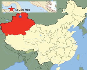
Xinjiang Oilfield Company (XOC), a subsidiary of PetroChina Company Ltd., has been prospecting, developing and producing oil and gas in the Xinjiang region of Western China for almost 30 years. Today, this region has the largest annual hydrocarbon output in the country. The Lu Liang oil field (Fig. 1), which contains millions of tons of recoverable reserves, is the most productive field in Xinjiang.
 |
|
Fig. 1. The Lu Liang oil field is located in the Xinjiang region of Western China.
|
|
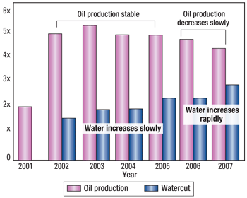
Discovered in 2000 and initially developed with vertical wells, Lu Liang has been producing light oil from Jurassic and Cretaceous reservoirs since 2001. Production remained both high and stable through 2005, when watercut began increasing rapidly and oil recovery began declining, Fig. 2.
 |
|
Fig. 2. Until 2005, oil production in Lu Liang Field remained stable, then it began declining as watercut rapidly increased.
|
|
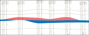
Lu Liang Field is a low-relief anticlinal structure whose primary reservoir is characterized by fairly low-resistivity sand lenses and pinchouts, a thin oil column, a complex oil-water contact and strong, natural water drive, Fig. 3. As a result, it proved difficult to develop bypassed oil accumulating in the upper few meters of the reservoir using vertical wellbores, which experienced bottom water breakthrough.
 |
|
Fig. 3. The light oil target reservoir consists of sand lenses with low structural relief, a thin oil column (red) and bottom water (blue).
|
|
To minimize watercut and maintain production, XOC drilled two horizontal wells in Lu Liang Field in 2006. Since conventional methods of landing and geosteering—mud logging and measurement-while-drilling with gamma-ray resistivity measurements—had proven unsuccessful, XOC decided to apply real-time imaging using laterolog azimuthal resistivity in these two wells. However, the danger always existed of landing the well too shallow or too deep. Also, the horizontal wellbore could accidentally exit the upper boundary of the reservoir or fail to maintain the optimal trajectory very close to it. Any of these scenarios would reduce net-to-gross (NTG) reservoir contact, bypass valuable reserves and lower ultimate recovery. In some cases, costly and time-consuming sidetracks would be necessary. Although both of these horizontal wells reached relatively high NTG, the goal of placing the horizontal trajectory near the top of the reservoir was not achieved. Both wells were completed below expectations.
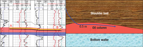
The company was planning a series of fast-paced batch horizontal drilling campaigns, and could not risk missing the sweet spot in every well. Due to thin oil targets and high structural uncertainties in areas far from reliable well control, XOC needed to land numerous wells accurately in real time, stay away from the oil-water contact, and steer wells horizontally within 0.5 m of the reservoir top (Fig. 4), which had proven unsuccessful using conventional geosteering techniques.
 |
|
Fig. 4. To maximize reservoir exposure, capture bypassed attic (red) and avoid the oil-water contact, horizontal trajectories required precise geosteering within 0.5 m of the upper reservoir boundary.
|
|
TESTING BED BOUNDARY MAPPING
In early 2007, XOC began experimenting in a heavy oil field with an advanced well placement technology that successfully mapped reservoir boundaries in real time. This technology, the Schlumberger Periscope deep azimuthal electromagnetic resistivity LWD system, makes 360° measurements that (when interpreted in real time by special software at the surface) provide both orientation and distance to formation boundaries up to 6.4 m (21 ft) around the borehole, even in the presence of anisotropy and dip variations, Fig. 5. Such a deep detection range enables well placement engineers, directional drillers and geoscientists to make proactive, rather than reactive, decisions for well landing and geosteering in real time.
 |
|
Fig. 5. Deep azimuthal resistivity bed boundary mapping technology detects formation and fluid boundaries up to 6.4 m (21 ft) around the borehole, enabling proactive geosteering.
|
|
Application of the real-time bed boundary mapper enabled XOC’s heavy oil wells to achieve an NTG ratio of more than 90%. In fact, five horizontal sections achieved 100% reservoir contact.1 Having experienced the precision and value of this new technology, XOC wanted to repeat similar benefits in wells targeting the thin Lu Liang light oil reservoir.
The service company well-placement team conducted a study to determine the feasibility of using the real-time bed boundary mapper in the Lu Liang low-resistivity light oil reservoir, given its unique challenges and uncertainties. Based on offset well data, the feasibility study demonstrated that deep azimuthal resistivity measurements were compatible with expected petrophysical properties of the reservoir. Because of its proprietary automated inversion process, the tool was capable of accurately detecting the top of the sand within a distance that met the project requirements, without relying on a predefined geological model. In collaboration with the well-placement team, the XOC engineers and geoscientists defined possible risk scenarios and corresponding risk mitigation strategies. Three horizontal wells were planned for the pilot test, which was implemented in 2007.
During drilling and geosteering operations, service company personnel worked closely with XOC’s regional geologist to capture and interpret real-time LWD data from the tool. Since the system presents updated maps of formation boundaries in real time, the team was able to accommodate structural uncertainties and take quick action to avoid drilling out the top of the reservoir while maintaining the horizontal section within 0.5 m of the top of the target zone. All three pilot test wells were successful, achieving an average 96% NTG reservoir exposure, with a significant increase in the productivity index (PI). The three wells produced four times more, on average, than vertical wells or horizontal wells drilled with conventional geosteering techniques. As a result, XOC felt confident to begin large-scale implementation of the real-time bed boundary mapping technology in the Lu Liang oil field.
LARGE-SCALE IMPLEMENTATION
In 2008, XOC batch drilled 25 horizontal wells in the target reservoir using the real-time bed boundary mapping system. In 2009, 19 more wells were drilled. Typically, batch horizontal drilling campaigns were conducted within a three-month period. XOC used its own rigs to drill the top hole and kickoff sections to a pre-determined inclination. From that point, Schlumberger and XOC collaborated to land the well and geosteer the horizontal section. Three different types of reservoir profiles were encountered, each sharing common objectives but presenting a different challenge:
• edge water type, with 3–4-m oil columns
• thin reservoir type, with 1–2-m oil columns
• bottom water type, with 4–5-m oil columns.
In all these wells, XOC deployed bottomhole assemblies with the real-time bed boundary mapping tool and conventional mud motors.
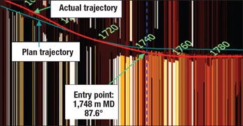
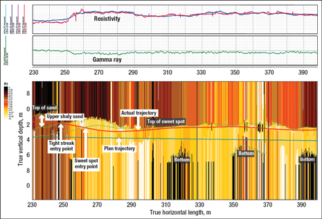
Due to limited well control and lack of high-resolution seismic data between offset wells, the well placement team had to update interpretations in almost every well. For example, while landing wells, the reservoir top often came in shallower or deeper than anticipated, requiring rapid adjustments of the trajectory. Nevertheless, with precise, real-time distance-to-boundary information in hand, all wells were landed smoothly inside the reservoir, Fig. 6. Once inside the target section, variations in dip and lateral facies along the horizontal trajectory were often encountered. Despite these challenges, all the horizontal sections were successfully maintained within 0.2–0.5 m of the top of the reservoir, maximizing reservoir exposure and staying well above the oil-water contact, Fig. 7.
 |
|
Fig. 6. Bed boundary mapping image of the landing section of one Lu Liang horizontal well, which landed successfully within the 0.5-m target window despite encountering the reservoir top deeper than expected.
|
|
 |
|
Fig. 7. The horizontal section of a Lu Liang wellbore remained within 0.5 m below the upper reservoir boundary despite encountering unexpected variations in dip.
|
|
A total of 47 horizontal wells were placed using the distance-to-boundary technology through the end of 2009, with an NTG ratio of 94%. The average length of each horizontal section drilled in the Lu Liang reservoir to date has been about 312 m with average length of reservoir exposure of 294 m. The few percent of borehole not exposed to oil-bearing sand was due to various laminations, interbedded shale breaks and pinchouts that were encountered along the horizontal section. No sidetracks were necessary. By placing the wellbore near the upper boundary without exiting the reservoir, drilling efficiency increased rapidly from year to year. Without real-time azimuthal resistivity bed boundary mapping, it may have been difficult to achieve comparable results.
Large-scale application of this technology in the Lu Liang oil field has yielded a number of economically valuable benefits. Compared to vertical offset wells and conventionally geosteered horizontal wells drilled in the past, the daily average watercut has decreased 70%. The recoverable reserve factor has increased by 20%, and production has improved by five times over the last three years. Significant increases in the PI ensured longer production sustainability. 
LITERATURE CITED
1 Zhang Jun Jie et al. “Proactive well placement using new boundary-mapping technology,” presented at the 14th Formation Evaluation Symposium of Japan, Sept. 29–30, 2008.
|
THE AUTHORS
|
| |
Song Yu Xin is Oil Field Development Manager for PetroChina Xinjiang Oil Co. He has more than 27 years of working experience in the industry and holds a PhD degree in petroleum engineering from Southwest Petroleum University in China.
|
|
| |
Mai Xin is Oilfield Development Vice Manager for PetroChina Xinjiang Oil Co. He has more than 16 years of working experience in the industry and holds a master’s degree in logging from the University of Petroleum (East China).
|
|
| |
Du Hong Lin is a Project Manager for PetroChina Xinjiang Oil Co. He has more than 14 years of working experience in the industry and holds a bachelor’s degree in petroleum geology from the University of Petroleum (East China).
|
|
| |
Li Qing is a Project Manager for PetroChina Xinjiang Oil Co. He has more than 13 years of working experience in the industry and holds a bachelor’s degree in petroleum geology from the University of Petroleum (East China).
|
|
| |
Parlindungan M. Halomoan is a Well Placement Domain Champion for China-Japan-Korea-Taiwan GeoMarket, Schlumberger. He has more than 12 years of working experience in the industry and holds a degree in geophysics engineering from the Bandung Institute of Technology.
|
|
| |
Yang Bin is a Well Placement Domain Champion for China-Japan-Korea-Taiwan GeoMarket, Schlumberger. He has more than 12 years of working experience in the industry and holds a degree in reservoir geology from the University of Petroleum (East China).
|
|
| |
Chow Yuk Ha is a Resistivity Product Champion for Drilling and Measurements, Schlumberger. She has more than nine years of working experience in the industry and holds a degree in electrical engineering from the University of Melbourne.
|
|


