A project in northern Italy demonstrates how the benefits of LWD can be extended to deep, hot wells.
Grant Affleck, Rob Christie and Mauro Troiano, Weatherford International Ltd.; Stefano Mazzoni and Massimiliano Borghi, Eni E&P
Searching for hydrocarbons in deep targets often entails high-pressure/high-temperature (HPHT) drilling. Environmental or technical limitations that constrain drilling to wellbores of 5¾ in. or less may prohibit conventional logging-while-drilling (LWD) tools from acquiring necessary data. A recent case study in northern Italy illustrates how using a fit-for-purpose, high-temperature LWD suite can extend LWD’s real-time trajectory and stratigraphic control benefits to deep, hot wells.
FIELD AND WELL OVERVIEW
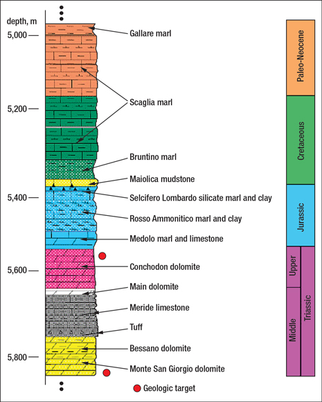
The Villafortuna-Trecate HPHT field is located in the western Po Valley of Italy, on the border between the cities of Milan and Novara. Discovered in 1984, the field consists of two Mesozoic carbonate oil reservoirs in the presence of intense tectonic phenomena: the upper reservoir (Conchodon dolomite and Dolimia Principale) and the lower reservoir (Monte San Giorgio dolomite), overlaid by a thick carbonatic and terrigenous sealing sequence, Fig. 1.
 |
|
Fig. 1. Stratigraphic profile based on Trecate Field offset wells.
|
|
Analysis of the residual oil in place showed the possibility of draining an oil-mineralized area in the lower reservoir with a sidetrack from a previous well. The original well had been temporarily plugged and abandoned in 2001 after technical problems prevented it from reaching TD. The objective of the new, sidetracked well was to recover oil from the oil-mineralized lower interval in an updip from two offset wells in the same field. A TD of more than 20,341 ft was targeted to ensure a safety margin from the estimated water-bearing zone. Because of uncertainty in the seismic data interpretation, the depth at which the well would intercept the target could vary by as much as 262 ft (80 m), in which case the target TD would be varied accordingly.
The sidetracked well also would need to confirm the presence of oil mineralization in the upper reservoir. A range of uncertainty of 98–164 ft (30–50 m) of the intercept depth existed because, on the basis of seismic interpretation, the well was expected to cross the upper reservoir in a fault zone. The level of uncertainty on both the formation type at target and the formation mineralization drove a decision to collect cores from the MS Giorgio formation. LWD was planned to enable continuous correlation for casing and coring points.
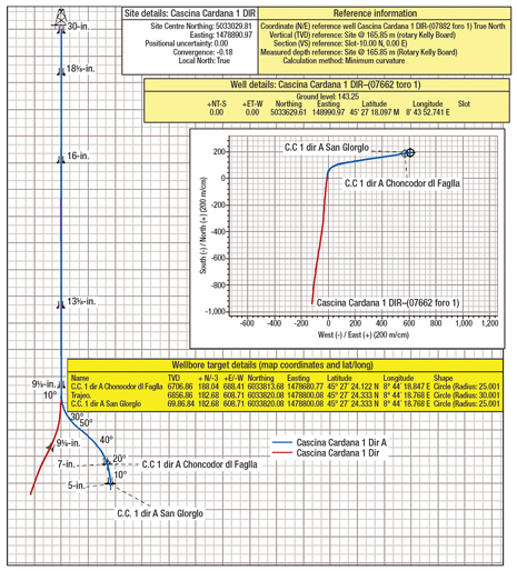
The well plan called for an 8½-in. sidetrack from the 9⅝-in. casing to the Medolo Formation upper interval, followed by drilling of a 5¾-in. hole to target. The uncommon 5¾-in. hole size was dictated by the 7-in., 38-lb casing with 5.795-in. drift ID, Fig. 2.
 |
|
Fig. 2. Sidetrack well plan, vertical and horizontal sections.
|
|
LWD PLANNING AND IMPLEMENTATION
Geological control of the well during drilling was limited by borehole diameter (5¾ in.), temperature (356°F static with 16,780 psi at bottom), mud density (drilling fluid with 1.94 kg/L mud weight and solid content of 38%) and required bits (PDC, leading to strong decay of any original petrographic characteristics of cuttings).
Because standard LWD equipment had experienced numerous failures at downhole circulating temperatures up to 320°F in the previous hole section, it was decided to use an HPHT LWD system to drill the 5¾-in. sidetrack. Weatherford provided standard and azimuthal gamma ray, resistivity, and bore and annular pressure sensors able to work at 356°F and 30,000 psi in nominal tool sizes from 4¾ in. to 9½ in., in conditions never before achieved.
The Monte San Giorgio dolomite is a low-porosity fractured dolomite, making it a critical reservoir for formation evaluation. Coring was deemed necessary once it was confirmed that the 5¾-in. hole had reached the reservoir. The coring indications about the effective porosity and presence of oil shows in the reservoir contributed effectively to reservoir formation evaluation.
PDC bits with five blades and 19-mm cutters were specified to drill a 20,000-psi compressive-strength formation. The aggressive behavior of this type of bit has historically caused strong decay of original petrographic characteristics of cuttings. The 1.94 kg/L oil-based mud (OBM) with 38% solids content exacerbated the reservoir data interpretation challenges. All these factors contributed to the critical need for gamma ray and resistivity logging while drilling to optimize identification of formation tops.
For the 5¾-in. hole section, according to the services requested, a 4¾-in. suite of HPHT LWD tools was used. The tools included directional MWD, pressure-while-drilling (bore and annular), multi-frequency resistivity and azimuthal gamma ray sensors.
To drill the new sidetrack well, each collar was powered by a dual-battery module assembly consisting of two innovative, high-temperature, intelligent batteries. These new-style lithium batteries enable logging at temperatures up to 392°F. Switching regularly between batteries helped maintain system power requirements under all drilling conditions and ensured readily available backup power in the event of cell failure.
The specialized batteries have two important operational considerations. The first is the maximum safety factor before the cells become unstable and vent. Internal testing has shown that the cells will vent once the internal temperature reaches 413°F. The second consideration concerns equipment operation at temperatures below 158°F, such as during deck and shallow hole tests. Extended use at low temperatures can cause high and erratic current usage, which can shorten battery life. Enabling a battery thermal-protection function prevents the pulser from working until the temperature reaches 158°F, thus extending battery life.
The MWD system was specifically designed for hostile-environment logging. It provides real-time directional and logging data through a pressure-modulated telemetry system for high-pressure/high-temperature drilling environments. It is able to operate and survive at temperatures up to 356°F, survive at 392°F, and withstand downhole pressures of 30,000 psi (207 MPa). An integrated directional sonde uses three orthogonal high-temperature accelerometers and magnetometers housed in a non-magnetic titanium alloy chassis to provide directional and toolface measurements that track the drilling path and orient the positive displacement motor during sliding operation.
The suite was also equipped with a pressure-while-drilling (bore and annular) sensor and programed for the runs to store all pressure data in memory every
5 s and all temperatures every 5 min. The result was continuous, highly accurate downhole measurement while drilling, wiping or tripping in/out of the hole. Accuracy was maintained within ±1.0 psi. Bore pressure, annular pressure and temperature, and equivalent circulating density were transmitted and plotted in real time to help minimize mud losses and optimize the mud program.
To log the well, a high-temperature, multi-frequency resistivity tool was combined with a high-temperature azimuthal gamma ray sensor, both rated to 356°F operating and 392°F survival temperature and 30,000-psi operating pressure. All data transmission to surface was achieved by the driver and pulser contained in the MWD system.
The high-temperature, multi-frequency resistivity sensor used three independent transmitter-receiver antenna spacings and two electromagnetic wave frequencies
(2 MHz and 400 kHz) to provide highly accurate measurements in the extreme conditions, with 12 fully compensated phase and attenuation measurements recorded every 10 s. The real-time-transmitted 2-MHz shallow, medium and deep-phase resistivity curves were very useful in formation identification and continuous correlation for casing and coring points.
Gamma ray information was acquired using a high-temperature azimuthal gamma ray sensor consisting of five banks, each with two Geiger Muller tubes. The number, size and symmetric distribution of tubes were chosen to provide the optimal combination of statistical precision and azimuthal sensitivity and to allow azimuthal measurements while rotating and/or sliding. The statistical precision of the gamma ray tool measurement is ±5 API at 100 API for 20-s unfiltered samples (±2.5 API with a five-point non-block filter), showing good correlation with wireline data.
In addition to total gamma ray, triggered azimuthal gamma ray data in quadrant format was transmitted in real time to maintain a good data density. Only after a set amount of gamma counts was accumulated was the data transmitted on surface. The combination of total gamma ray, azimuthal and resistivity data while drilling made formation identification and continuous correlation for casing and coring points possible. Gamma ray data in octant format (eight-sector borehole), sampled and stored in memory every 10 s, was sent to the office at the end of each run to be analyzed and processed with specialized software. Image logs and dip interpretations played an important role in improving the characterization of reservoirs by showing graphic details about texture and structural features, such as faults and fractures, and by identifying dips and defining the angle and direction of tilt in sedimentary layers.
For the 5¾-in. section, a 4¾-in. suite of LWD tools was used. These included the high-temperature MWD tool with integrated directional sonde, bore annular pressure, multi-frequency resistivity and azimuthal gamma ray. The objective of this section was to drill through the Monte San Giorgio dolomite reservoir.
MWD measurements provided included on-demand borehole inclination and azimuth, environmental vibration severity measurement, wellbore annular pressure, and bore annular pressure. LWD measurements included high-temperature multi-frequency resistivity, borehole-compensated phase-shift resistivity and azimuthal gamma ray.
LOG MEASUREMENTS ACQUIRED WHILE DRILLING
In addition to the temperature and pressure measurements recorded in real time, 12 resistivity measurements and oriented azimuthal gamma ray measurements were acquired while drilling. The resistivity measurements were made at two frequencies—2 MHz and 400 kHz—and at three depths of investigation—20 in., 30 in. and 46 in. These were repeated for both phase and attenuation for a total of 12 measurements.
The azimuthal gamma ray records eight values in memory around the borehole and sends four values uphole in real time. These values are oriented using the directional package, and then are processed and mapped to a false color palette to provide an image of the borehole. The resulting imaging log is depicted in a dark/light scale that portrays high/low gamma values.
Two different images are typically generated: a static image, where the minimum and maximum values of the measurements for the entire data set are mapped to the color palette, and a dynamic image, where a user-defined depth range determines the minimum and maximum values, which are then mapped to the color palette. The static image is an absolute scaling of the measurements, whereas the dynamic image is a relative one, which also provides better contrast in areas with small changes in absolute values.
After a correctly oriented image is made, the bedding planes can be delineated. Planes in 3D space are represented in 2D using sinusoids. The geoscientist picks the sinusoids that represent the apparent dip angle and azimuth of the bedding plane. Using the directional information, true dip is calculated from the apparent dip and can be referenced to either magnetic north or true north by correcting for magnetic declination. The dips are then plotted using tadpoles, with the head of the tadpole defining dip angle, and the tail pointing in the downdip direction (where north is up).
LOG RESULTS AND BENEFITS
The primary logging objectives were to use the gamma ray and resistivity data to 1) set the casing shoe exactly between the overpressure zone and the depleted zone by correlating the new sidetrack with the offset well in real time while drilling, 2) identify coring points and 3) clearly identify formation variations.
These objectives were achieved despite an in situ static temperature of 357°F and an observed circulating temperature of 320°F. The hostile-environment LWD suite overcame the static temperature limitation of 338°F for standard LWD tools and enabled the operator to log and evaluate the reservoir while drilling.
The operator identified several benefits to logging high-temperature gamma ray and resistivity data in real time.
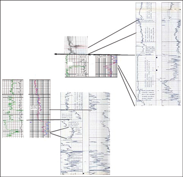
For one thing, real-time continuous gamma ray and resistivity curves while drilling enabled the operator to correlate while drilling, day by day, the sequence crossed in the new sidetrack well with the similar sequence crossed in offset wells, Fig. 3.
 |
|
Fig. 3. Correlation between the new sidetrack well and previous offset wells.
|
|
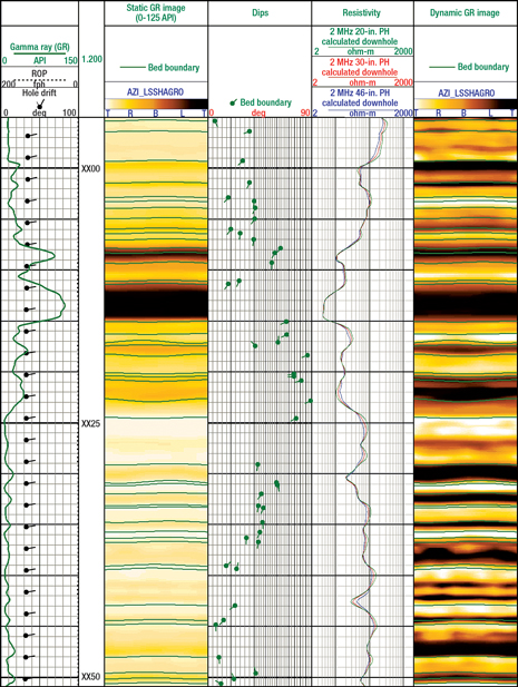
The real-time correlation also made it possible to identify the presence of a main direct fault and to estimate its reject. The upper reservoir was identified 446 ft (136 m) higher than the prognosis estimation. Although this fault was expected, seismic had been unable to exactly define the stratigraphic position, Fig. 4.
 |
|
Fig. 4. The composite data plot shows gamma ray and resistivity data together with static and dynamic borehole gamma images and interpreted dips.
|
|
The correlation and careful cutting analysis allowed the operator to place the casing shoe exactly at the top of the upper reservoir.
The continuous real-time gamma ray and resistivity curves allowed the operator to better define the stratigraphic setting. This definition was critical because using a PDC bit often completely destroys the lithological characteristic of the drill cuttings. Having good stratigraphic control in the absence of direct lithological data allowed the drilling to continue without the need to pull the bottomhole assembly out of the hole and change the bit type for better and unaltered cuttings.
The continuous data curves also allowed the operator to identify a carbonate sequence in the lower section, which prompted the decision to cut a core at bottom. The core results, which showed the rock to be very tight, and log correlation resulted in the decision to plug and abandon the lower section and to produce the upper reservoir, with very good results. New wells in the project were planned as a result of this well.
Finally, real-time annular borehole temperature measurements gave the operator an idea of the temperatures present in the sequence. 
|
THE AUTHOR
|
 |
Grant Affleck is the Business Development Manager of Technology for Weatherford’s global Drilling Services group. He has worked in the oilfield service industry for more than 20 years, including as a field engineer and country manager prior to joining Weatherford in 2005. Mr. Affleck holds a BS degree in geology from the University of Edinburgh.
|
|
| |
Rob Christie is a global Geoscience Development Advisor for Weatherford International in Calgary. He joined Weatherford as a field engineer, and transferred into engineering and geosciences in 2001, where he became the leader for borehole imaging. Mr. Christie holds degrees in marine biology and mechanical engineering from the University of Victoria.
|
|
| |
Mauro Troiano is Drilling Services Supervisor in Weatherford’s Europe and Africa region. He has also worked as a drilling engineer with Weatherford and previously was a project engineer with an oil and gas consulting company. He holds an MS degree in mechanical engineering from the University of Ancona, Italy.
|
|
| |
Stefano Mazzoni is the Operative Geology Team Leader of Eni E&P for Italian activity. He is responsible for planning and follow-up of geological acquisition for exploration, storage and development wells, both onshore and offshore, in critical-condition, carbonate, and shale and sand sequences. Prior to his current position, Mr. Mazzoni worked with Eni in various regions in Italy and in Gabon and Algeria. He holds a master’s degree in geology from Bologna University.
|
|
| |
Massimiliano Borghi is responsible for professional petrophysics and formation evaluation for UGT-Eni E&P.
|
|


