What's new in exploration
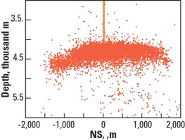
HDR update. Without repeating everything that I wrote in this column in February 2004, here’s an update of the Hot Dry Rock geothermal project in Cooper basin, Australia, which is making slow-but-sure progress. Nothing has occurred that would change the mindset of any observer that the area has tens of billions of barrels of oil-equivalent energy in the form of heat stored in granite. Geodynamics completed its first well, the Habanero-1, which, at 14,505 ft, is the deepest well ever drilled in mainland Australia. It was drilled into the hottest known non-volcanic HDR resource in the world (250°C; 482°F). There were many problems during drilling, including unexpected natural fractures, higher than expected overpressures and steam – all of which might bode well for the project, although the company still intends to inject water. One of the main risks is establishing a good, extensive frac job that propagates in a mostly horizontal direction. That now appears to have been accomplished. A microseismic monitoring network was used, monitoring from various new and existing wells, and gave a good map of the fracture network, which was presented at last fall’s SEG meeting in Denver (see top figure). Drilling the Habanero-2 was recently successfully completed, with the well reaching 14,297-ft TD. Hydraulic connection between the two wells, spaced 1,640 ft apart, has been confirmed. Drilling problems continue, although it was good to see “first steam” produced, even though it was produced during a fish recovery operation. As this goes to press, a very stubborn bridge plug is about to be removed by a coiled tubing drilling unit, after lowering overpressures at the wellhead from 5,200 psi down to 3,700 psi by injecting brine. The Reservoir Testing Program will proceed subject to the plug retrieval/ drill-out. A decision was made to speed up development of the demonstration power-generation plant. Geodynamics Power Systems (GPS) is also preparing detailed bids for generation plants totaling 85MW. Despite the drilling problems, the goal remains: to generate large-scale, zero-emission power, at costs similar to fossil-fuel power generation, using a closed-loop Kalina Cycle process, as is now in use in Iceland. Geodynamics has support from Metasource, Woodside Petroleum Ltd and Origin Energy Ltd. New logging probe to test ideas. Geothermal researchers at Sandia National Laboratories have pushed the limits of HPHT sensors. The newly developed sensors are allowing geologists, geophysicists and well-log analysts worldwide to make more precise measurements of subterranean conditions. One use is for earthquake-related phenomena. Another is for geothermal resource assessment.
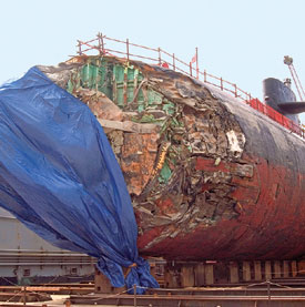
The new tools use Quartzdyne quartz pressure and temperature sensors with a relative resolution of less than 0.005 psi and 0.01°C, making the instruments extremely accurate, almost as accurate as what you can get in the oil field. Two years ago, Sandia began working with the USGS to monitor geothermal wells. By monitoring extremely small temperature and pressure changes in the deep subsurface, earthquake data might reveal new information, because reservoirs (of all types) can sometimes be 5–10 mi long, creating a much larger area of sensitivity to the waves generated by small quakes than the area used by seismic detectors. Large earthquakes, sometimes far away, create waves that cause bursts of micro-earthquakes in the area. Some persist for days after other seismic activity has returned to normal. Sometimes, pressures in reservoir fluids increase after earthquakes, and movements in the rocks can be measured. Before, researchers could not record the pressures frequently enough to determine if there was any response to seismic activity. Now they are recording temperatures and pressures once every 2.5 seconds, and with very high accuracy. Still in the planning stages is a drilling project to bore into active tectonics off the coast of Japan in Nankai Trough. The target is 19,000 ft below the seafloor, in 6,300 ft of water. They intend to place these instruments in a fault zone to better understand earthquake precursors. In simple terms, strain builds up between two moving rock masses until it overcomes friction, creating an earthquake. There’s a hypothesis that pore fluid pressure in the rocks affects this dynamic. Perhaps increasing pore pressure could push the rock faces apart, just enough to allow slippage. So, it’s possible that earthquake timing could be governed by fluid pressure. Just when you thought you knew where you were. The picture at the bottom of this page is of the Los Angeles-class fast-attack submarine USS San Francisco. It’s in dry dock to assess damage sustained after running aground about 350 mi south of Guam in January. The sub hit an unmapped seamount, leaving one person dead and more than 60 people injured. It had been operating without radar, to avoid surveillance, while using US Navy seafloor maps and satellite imagery. The seamount almost breaks the surface. Surface photography had shown a shadowy area, but the seamount was not mapped on any charts onboard.
|
|||||||||||||


- Quantum computing and subsurface prediction (January 2024)
- Machine learning-assisted induced seismicity characterization of the Ellenburger formation, Midland basin (August 2023)
- Regional report: South Australia: New life in a mature basin: S.A.’s Cooper basin CCS and exploration opportunities (May 2023)
- What's new in exploration (March 2023)
- Seismic and its contribution to the energy transition (January 2023)

