LWD/MWD proximity techniques offer accelerated relief well operations
Well Control & InterventionLWD/MWD proximity techniques offer accelerated relief well operationsMWD tools with proximity detection compress the work schedule and enhance overall reliability; but special drilling techniques are required to take advantage of these highly advanced toolsL. William (Bill) Abel, Abel Engineering, Houston, and James N. Towle, Scientific Drilling Inc., Houston Relief well projects can now employ aggressive techniques that will dramatically improve overall efficiency and reliability. These techniques employ the proprietary LWD/MWD tool, MagTrac, * with sound project management, well planning and appropriate directional drilling tools to allow the relief well project to be completed in less time and with less risk. Hole problems are potentially reduced because openhole logging and pipe tripping is eliminated during the ranging-to-target phase. Reducing the overall time and costs required to reach the objective positively affects pollution impacts and reserve losses. The overall result is an aggressive relief well strategy with minimal risks. The method uses a combination of drilling techniques and specialized logging services and tools, including:
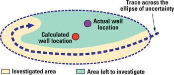
RANGING REQUIREMENTS FOR RELIEF WELLS The objectives of a relief well project are to intercept, communicate and control the blowout. The key to success is to overcome unknowns in the position of the blowout well, known as the ellipse of uncertainty. These uncertainties usually are so large that intercepting the blowout well with the relief well would be impossible unless the position of the blowout can be mapped relative to the relief well. Ranging must be performed and direction and distance determined. Once relative position is known, relief well trajectory can be modified to make an intercept. Fig. 1 shows how an LWD/MWD tool can be used to investigate the ellipse of uncertainty in a systematic way. The authors suggest that a target depth interval for proximity detection can be chosen and the borehole then tracked across the ellipse and turned in an ever-tightening path until the blowout casing or drillstring is precisely located.
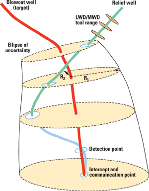
TRAJECTORY The trajectory must be planned to take advantage of and optimize the tool and techniques. the maximum range of the tool (see tool section for specifications), requiring that proximity detection occur within this range. Fig. 2 illustrates a trajectory that would be drilled using LWD/MWD proximity detection to reduce a large ellipse of uncertainty. By planning an effective sweep pattern, the relief well and target survey uncertainties are combined and a relief wellplan is designed to detect any target within a cylinder along the target survey path.
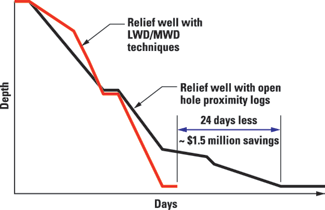
RISK REDUCTION For more than 20 years, the conventional method for ranging from the relief well to the target blowout well has been to use an electromagnetic logging tool that must be run in openhole to achieve optimum data. Now, LWD/MWD/wireline techniques eliminate the need to pull out of the hole, since the data is pulsed to the surface either via the mud column or EM-MWD. A well being drilled will tolerate only a finite number of openhole logs and trips. Rotating and circulating while logging versus tripping out to log is well known to create less risk. LWD/MWD proximity detection eliminates delays caused by hole problems (sticking, keyseats, sluffing, high drag, etc.) encountered during trips required for openhole ranging. Rig time savings are conservatively estimated to be 80%. COST AND EXPOSURE VS. BENEFITS Proximity surveys take less than one hour, including time for data interpretation. By comparison, openhole techniques require pipe to be tripped out, and then the log run on wireline, which can take as much as 36 hours in a deep well. The cost benefit can be significant, given that ten or more surveys may be required. Fig. 3 illustrates the potential time savings on an actual relief well project. Considering the cost of some offshore operations, ten logging runs would result in significantly higher costs.
Schedule often is an important consideration in relief well operations. LWD/MWD proximity runs provide a definite advantage over openhole methods. Perhaps the most important consideration is that if pollution is occurring, the clean up or environmental damage will be reduced because the time the well is out of control will be reduced. To summarize, the benefits are:
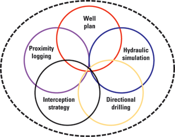
OBJECTIVES COORDINATION The primary goal of a relief well project is to bring the wild well under control. Each project phase will be performed to support this final objective. All aspects of the planning, engineering and execution must done in such a way that the objective of each individual subsection is not compromised. The relief well project requires several complex engineering tasks and experienced-based operations. Hydraulic simulations using sophisticated software with two-phase transient capabilities may be required. Often, intense diagnostics are necessary to determine the most probable scenario in the blowout. Additionally, a communication strategy must be developed that fits with the overall kill design. All must be feasible and operationally sound for the particular circumstances. Pumping equipment must be sized for a certain horsepower and deliverability, based on the hydraulic simulations. This is based primarily on kill fluid rhelogy and relief well geometry, as well as reservoir parameters. If a liner was run, the resulting friction losses could result in higher horsepower requirements. Therefore, the results of drilling the relief well may have huge impacts on the killing requirements after interception with the blowout well. For this reason, various critical factors in the relief well must be coordinated during planning and execution. The concept of overlapping responsibilities is illustrated by a Venn diagram, Fig. 4.
RELIEF WELL TEAM There are very few relief well projects and, consequently, little, if any, hands-on experience. Therefore, an experienced relief well team may need to be out-sourced from the consulting and/or service organizations. The most desirable situation is a small and efficient group led by an experienced multi-talented team leader. For the technique to be fully effective, the authors suggest that an experienced team be fielded and given the responsibility for designing and implementing the relief well project. Such a team will provide fully integrated services. including:
PASSIVE RANGING TOOLS Passive ranging technology has a long history, beginning with Shell’s work1 in 1972. At that time, electronic multishot tools were not available, and the actual analysis of the total field and single shot compass logs was extremely cumbersome. The increased sensitivity and transmission capability of today’s 16-bit MWD technology makes passive ranging a reality. LWD, EMS, and wireline technology now allow use of magnetic proximity logs to rapidly determine the range and direction to a nearby casing string or fish. Table 1 compares the LWD/MWD technology method to electromagnetic tool methods.
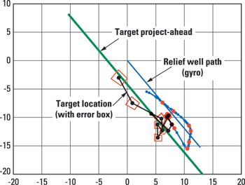
LWD AND WIRELINE PROXIMITY DETECTION LWD/MWD proximity detection was developed to reduce rig time and wireline requirements for ranging operations. When ranging, LWD/MWD proximity detection uses high-precision MWD shots to obtain a magnetic proximity log. The proximity log then is used to indicate target range and direction. In the 1970s, tests1 established that magnetic interference from a nearby casing string could be interpreted to yield range and direction to it. At that time, EMS (electronic multi-shot) tools were not available. Careful (and tedious) analysis of multiple dip and compass shots guided intercept operations. An intermediate step in the development of passive ranging was the MagRange tool.2 The introduction of 16-bit MWD technology made MWD proximity detection a reality. By using MWD tools to measure and interpret casing interference, LWD/MWD proximity detection addresses the previous limitations of passive ranging with a precise magnetic model of the target casing and dogleg-induced variations in the earth field components. A key element in successful completion of a relief well is the well planning based on proximity log analysis. LWD/MWD proximity detection includes calculations to provide an XYZ directional target for well planning purposes. LWD/MWD proximity detection has successfully guided relief wells to intercept vertical and small diameter casing without benefit of target survey data. LWD/MWD proximity detection also has been deployed successfully for a first-pass intercept of low-angle, near-vertical targets without need for specialized ranging tools. These are difficult conditions for any ranging technology because they require precise toolface orientation. Proprietary methods allow LWD/MWD proximity detection to obtain target location with respect to magnetic toolface, even in the presence of strong magnetic interference produced by the target. LWD/MWD proximity detection has also accomplished first-pass intercepts on target casing as small a 4-1/2-in. OD. Operationally, LWD/MWD proximity detection requires that pumps be off during data collection. Usually this is best accomplished by drilling to a preset depth and acquiring the proximity log with pumps off by picking up the drillstring at preset intervals over a stand. Alternatively, the proximity log can be acquired by cycling the pumps and drilling ahead over each data interval. Wireline can be used to substitute for mud pulse or EM data recovery. This method requires that a mono-cable wet connect be made when survey data is taken. Alternatively, the data can be memorized in the downhole package and recovered when the assembly is brought to surface. Wireline techniques may be advantageous in projects where cost is an important and overriding factor. Regardless of the data recovery method, data collection is performed by the same downhole instrument package. CASE HISTORIES The tool was recently used to plug and abandon two wells in New Mexico (near Farmington) and West Texas (Permian basin). In these projects (non-blowout conditions), wireline was used to recover data, rather than adding the expense of mud pulse data transmission. The difference in these P&A projects and a relief well was that a pump-to-kill operation was not required. Otherwise, all the facets of ranging, locating casing, interception and communication were identical to a wild well control operation. In the New Mexico gas well, the first attempt failed to P&A the well and re-enter its lower portion from the original wellbore. The P&A objective was to intersect severely damaged casing in the presence of unknown junk at about 1,000 ft TVD. LWD/MWD/wireline proximity detection was used to range from the failed sidetracks back to the corroded wellbore from the outside of casing. The well was paralleled, until the target was judged undamaged using the proximity log. The sidetrack was used to re-enter the original non-corroded section of casing. Target well was cased with 4-1/2-in., was near vertical and had no survey data available. Fig. 5 shows the target well’s complex path and the resulting ranging shot, which enabled a first pass intersect of this target casing. The target well was drilled vertical and, as such, had severe changes in azimuth. As illustrated, the target turned under itself and intercept was achieved drilling a NW path.
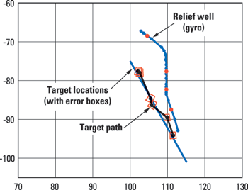
In West Texas, LWD/MWD/wireline proximity detection was used in a more conventional P&A application where survey data was available. LWD/MWD/wireline proximity detection was used to plug a problem well at 4,000 ft TVD, as required by Texas Railroad Commission rules. Proximity detection shots determined target survey offsets, from which a downhole projection of target was based only on the remaining downhole survey shots (light blue line in Fig. 6). As a result, the target and possible doglegs were mapped in detail, improving the likelihood of a first pass intercept. The target was successfully milled and re-entered and P&A operations completed.
ACKNOWLEDGEMENT The authors wish to thank Scientific Drilling Inc. and its management for their permission to publish and for their participation in this article. LITERATURE CITED 1. J.D. Robinson and , J.P. Vogiatzis, “Magnetostatic Methods of Estimating the Distance and Direction from a Relief Well to a Cased Wellbore,” Journal of Petroleum Technology, June, 1972. 2. F.J. Morris, , R.L. Walters, and J.P. Costa, “A new method of determining range and direction from a relief well to a blowout,” SPE 6781, Presented at the SPE Fall Technical Conference, Denver, 1977. 3. Abel, L. W., et al., Firefighting and Blowout Control, Abel Engineering, 1994. |
|||||||||||||||||||||||||||||||||||||||||||||||||||||||||||||||||||||||||||||||||||||||||||
- Coiled tubing drilling’s role in the energy transition (March 2024)
- Using data to create new completion efficiencies (February 2024)
- Digital tool kit enhances real-time decision-making to improve drilling efficiency and performance (February 2024)
- E&P outside the U.S. maintains a disciplined pace (February 2024)
- U.S. operators reduce activity as crude prices plunge (February 2024)
- Drilling advances (January 2024)

