Guyana basin: A new exploration focus
SPECIAL REPORT: GEOPHYSICS & GEOLOGYGuyana basin: A new exploration focusWhy has there been so much interest offshore Guyana? New seismic and thorough analysis shows why the region is rich in prospectsWarren Workman, CGX Energy, Calgary
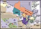
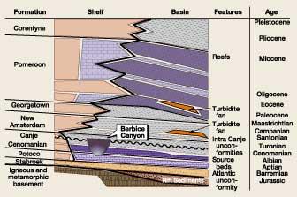
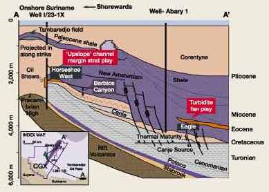
Background Recent work published by Pettingill indicates that all giant oil fields discovered in the 1990s are turbidites.1,2,3 Recent increases in Guyana basin concessions have focused on turbidite exploration. The last significant drilling in the basin occurred in the mid ’70s, before the industry began focusing on turbidites as a result of offshore discoveries in the North Sea, Brazil, West Africa and deepwater Gulf of Mexico. Pettingill also pointed out that stratigraphic closure was the trapping mechanism in many fields. The Guyana basin contains stratigraphic and sedimentation framework comparable to Brazil’s Espirito Santo and Campos basins, especially as regards shelf and basin stratigraphy. The basin has significant amounts of mature, marine source rock in the Canje formation of Cenomanian to Turonian age. These correlate with the source rocks of Eastern Venezuela, Maracaibo and Trinidad. The main challenge for petroleum exploration remains to define prospective traps along the migration path from mature source rock. It is likely that major accumulations will have a significant stratigraphic trapping element in this passive-margin basin. Canje-sourced oil in Tambaredjo field, Suriname, provides clear evidence of long-range migration. Geologic Setting The Guyana offshore basin is a passive, continental-margin-style sedimentary accumulation that has all the elements to become a major hydrocarbon province. The sedimentary section is Mid-Cretaceous to Pliocene in age. These sediments range from onlap of Precambrian basement in the west to over 29,000 ft of section to the east, before thinning out in deepwater areas. The main tectonic element of the basin is a major east-normal fault zone with more than 5,000 ft of net throw occurring near the end of the Cretaceous. This faulting formed the ancestral continental margin. Subsequent deposition has prograded the continental margin over 30 mi northeastward along the basin axis. Studying the figures gives a better sense of the basin geology. Fig. 1 shows the basin’s major elements and recent concessions; Fig. 2 is the overall basin stratigraphy; while Fig. 3 is a generalized cross-section near the basin’s central axis.
The basal formation is the Stabroek. It is Cretaceous–Barremian in age and is dominated by continental shales and sands deposited on the "Atlantic" Pre-Cretaceous unconformity. Overlying the Stabroek is the Aptian-aged Potoco formation, a carbonate that is the age equivalent of the productive Golden Lane reef trend in Mexico. Recent seismic has illuminated the potential for shelf-edge, reef-like features at depths of 26,000 ft.
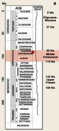
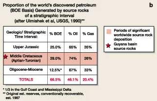
At the end of the Potoco, a marine inundation begins and continues through the Lower Maastrichtian age, interrupted only by the Berbice Unconformity. The youngest portion of this package comprises the maximum flooding interval in the basin and provides excellent seal / trap potential. The Cenomanian to Turonian interval contains the Canje formation, which is the main hydrocarbon source rock in the basin. The Canje is the lateral equivalent of other prolific source rocks in the region: the Naparima Hill in Trinidad, the La Luna and Querecaual of Colombia and Venezuela. The Canje comprises mature, anoxic, marine-calcareous mudstones associated within the Cenomanian to Turonian interval. It primarily generates high-GOR light crude. Comparison to Eastern Venezuela, Maracaibo and Trinidad shows that equivalent source rocks have generated 1,580 billion bbl oil in place.4 This anoxic interval is the earliest major manifestation of the Africa / South America separation found in Guyana basin geology. Four wells in the basin that penetrate the Canje have 650 to 980 ft of rock containing 2% to 6+% total organic carbon; this is a first-class source rock when mature. Figs. 4a and 4b show that 29% of all recoverable oil and gas reserves generated worldwide came from source rocks in the Aptian to Turonian interval.
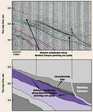
Oil Migration The shelf equivalent of the Canje contains one major regional unconformity, with seismic evidence for a second unconformity; this is manifested in the 200,000+ acre feature called Berbice Canyon, Figs. 1 and 2. The canyon appears as an unconformity in other parts of the basin. The feature shows on a seismic line that demonstrates the canyon-like cut on the right side with the less-angular, unconformity pinch-out on the left side, Fig. 5. Age of the unconformity is interpreted as intra-Canje based on seismic interpretation and well ties. Canyon infilling – with sand at the base and shaling out in the upper portion – is based on strikingly similar analogies from the Espirito Santo basin of Brazil.5
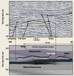
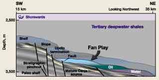
This canyon feature could provide an excellent migration path for Canje-sourced oil. The Chicontepec field of Mexico is an example of a canyon-like feature of the same size which provides both a reservoir and seal system in the nearby Atlantic margin.6 Overlying the Canje is a regressive Maastrichtian to Lower Tertiary package. On the shelf, this sequence is represented by the New Amsterdam and Georgetown formations. The sequence is a series of upwards-coarsening cycles capped with sands and thin carbonates. The Georgetown is the continental sand and shale facies at the top of the shelf sequence. In the basin equivalent, the entire time section is a distal-marine mudstone / shale sequence. The basin’s only oil field is located in the upper part of this package: Tambaredjo field, onshore Suriname, Fig. 1. Reserves in this field are estimated at 900 million bbl oil in place, with recoverable reserves of 153 million bbl. The oil has been fingerprinted to the Canje source rock and varies from 16° to 21° API, increasing with depth. The oil pool has been water washed / biodegraded, or differentially fractionated, and has lost its light ends due to its shallow 650 to 2,000-ft depth. Based on mapping and thermal gradients from well logs, the deepest portion of the basin reached the oil window beginning in the Eocene. Oil in Tambaredjo field has migrated over 60 mi since the Canje reached thermal maturity in the source kitchen. Long-distance migration is obviously at work in this basin. Near the end of the Cretaceous, the major faults that formed the South American continental margin were active in the Guyana basin. These faults have more than 5,000 ft of net throw in the deepest part of the basin. They formed the earliest, clearly defined continental margin in South America. The Tertiary basin that formed resulted from a trapdoor, down-thrown block near the Canje Source Kitchen. The Guyana trapdoor basin is flanked by Pomeroon plateau to the northwest and Demerara plateau to the southeast. Recent bathymetry still reflects this situation. Since fault formation, the continental margin prograded over 30 mi to the northeast during the Tertiary. Wells Drilled The basin has been penetrated offshore by 10 wells in Guyana and 20 wells in Suriname, covering a 58,000-mi2 area. The central part of the basin is underlain by a rift package containing clastics of volcanic origin. These were penetrated by the I23-1/X, offshore Suriname, Figs. 1 and 3. No petroleum-prospective section was encountered in that well. A key well in the basin is Abary-1, drilled to test down-thrown-block trapping at the base of the above-mentioned faults, Fig. 3. The primary target was a structural reversal in the hanging wall of the fault. The well was abandoned at 13,091 ft, before reaching its projected 15,000-ft target, due to circulation difficulties; the well penetrated several significant oil and gas shows. Gaseous C1–C5 hydrocarbons were recorded in the mud log from several zones below 9,800 ft. During drilling, an oil sample from the mud was analyzed at 34.7° API. On the shelf area, shelf-margin carbonates and sands dominated Paleocene to Middle Miocene deposition, with abundant sand farther west on the shelf. Onshore wells are greater than 90% sand with a few stringers of carbonate or clay. Mahaica-1 and -2 wells in Guyana – drilled to test the Pomeroon shelf carbonates – were unsuccessful, principally due to lack of seal. Their connection to an oil-migration path is also suspect. It is noteworthy that within the Maastrichtian to Lower Tertiary package lies the North Coroni member – a series of turbidite sands encountered in the North Coroni-1 well – directly overlying the Cenomanian, 14,371 to 14,689 ft deep. The North Coroni member comprises a 164-ft, net sand thickness of 20% to 30% porosity. Grain size is fine to coarse. Preservation of porosity at this depth is promising for the basin. Turbidite Prospects Within the basin, deposition from the Paleocene to the Middle Miocene was dominated by deepwater shales and marls. Seismic interpretation tied to the Abary-1 well indicates the potential of turbidite fans that have not been drilled. A sample of these features on a strike line from the 1999 CGX/Western long-offset seismic survey is shown on Fig. 6, with an accompanying interpretation. The features are Lower Eocene to Oligocene in age and have a mapped relief of over 650 ft and an areal extent greater than 100,000 acres. Fig. 7 shows a dip cross-section schematic over the turbidite features. The basinal Pomeroon provides excellent seal for the mapped turbidites.
The stratigraphic section containing the turbidites is correlative with Campos basin turbidite deposition in Marlim and Albacora fields.7 AVO and amplitude analyses have confirmed these prospects on the CGX acreage. The Eagle Prospect has a mapped extent of over 29,000 acres, with an estimated (p50) reserve potential of 850 million bbl recoverable. This feature has over 1,640 ft of vertical oil column to the mapped oil-water contact. Plans are currently underway to drill the Eagle Prospect in mid-2000. Overlying the Pomeroon is the Corentyne formation, which is a sand-dominated, prograding clastic wedge at the top; this grades to a clay-dominated marine deposition at the base. The formation has potential for significant reserves, especially in the deepwater section, if a connection to the Canje source beds and/or a later productive source rock can be established. Conclusion In light of all the evidence – including seismic, well data, charge
modeling and success in turbidite plays elsewhere – the recent increase in Guyana basin concession
activity appears well justified. These facts and up-to-date analysis techniques indicate probable exploration
success in Guyana basin over the next few years, commencing with the CGX drilling program scheduled for May
2000.
Literature Cited Note: A more extensive bibliography may be obtained by contacting the author at: wworkman@internode.net or via: www.cgxenergy.com.
The author
|
- Applying ultra-deep LWD resistivity technology successfully in a SAGD operation (May 2019)
- Adoption of wireless intelligent completions advances (May 2019)
- Majors double down as takeaway crunch eases (April 2019)
- What’s new in well logging and formation evaluation (April 2019)
- Qualification of a 20,000-psi subsea BOP: A collaborative approach (February 2019)
- ConocoPhillips’ Greg Leveille sees rapid trajectory of technical advancement continuing (February 2019)

 Warren
G. Workman is vice president of exploration for CGX Energy Inc. and
president of Workman Energy Ltd., Calgary, Alberta. He is an independent petroleum geologist with 26 years of
experience in exploration consulting, joint ventures – domestic and international – including
geological, seismic and management experience with Amoco, Unocal and Canadian independents. He earned a BSc in
Geological Engineering at Queen’s University, Kingston, Ontario.
