What's new in exploration
As an explorationist, I am motivated by risk-taking v. aversion. Every day with my money, and sure, the company’s. I recall investment meetings with upper management about drilling this or that, here or there, with strong arguments for source, seal, migration, trap, reservoir, and various levels of political factors for whatever location. Since we only told management to drill from our locations of choice, arguing about which one was less risky or more important was merely theater.
Earlier-era decision-making. Managers were led to believe they were leaders, who made the wisest choices. I learned from their ascension into the corner office. Engineering associates were from a never-risk-taking upbringing. I marveled that engineers would recommend investing hundreds of millions of dollars in steel, based on my paper-formulated assertiveness following a single discovery. How very much they would banish me, if we knew the real P10 v. P50. I assumed their calculations, with 3x “safety factors,” would always prevent disaster.
Once, I received a ship-to-shore call in the middle of the night from a senior drilling production V.P. about a certain uprighting ceremony, offshore in the Java Sea. Our platform support columns went totally underwater. Not what was expected. Of course, government dignitaries were onboard a nearby observation ship. Since the new seafloor jacket was exactly 20 ft below msl (mean sea level), I could advise that the issue was a mistake in the seismic vessel’s vertical reference point when seismic and hazard data were processed.
The steel legs were left in place, and a “booster” chair arrangement was fabricated in Singapore; $$$. That call was not about my work. The favor given later turned into a cooperative rescue by that same drilling department of my crew and ship in the mouth of the Amazon.
Reference points matter, both vertical and horizontal. No one wants to spud “here;” then find out later, I meant “over there.” More than one exploration or offset well has failed for lack of a comparative x, y between seismic and drilling rig. Examples offshore include the Amazonas, Arzana Island, Northwest basin, and the Cook Inlet. Onshore examples are Eagle Ford, Neuquén, and Sac basin, too? More than one explorationist has earned success mining existing seismic data for SEG-Y errors. CO2 sequestration projects, absolutely, should pay attention to modernizing well location surveys, deviation surveys, and seismic data. And Q-C all new data collection concerning the subsurface.
Takeaways from IMAGE. SEG and AAPG, plus new partner SEPM, held the third annual International Meeting for Applied Geoscience and Energy (IMAGE), from Aug. 28 to Sept. 1 in Houston, Texas. The conference grouped industry survivors, STEM candidates, and energy thinkers from a disappearing knowledge base under one roof. The conference made for an affordable [for the societies] meeting that actually still mentions oil exploration geoscience.
A technical program of more than 1,000 presentations, along with networking, made the gathering in Houston THE go-to event. Details are on each society's website.
A key topic, in my opinion, was the overall attitude: Discovery Thinking - Integrating Geology and Geophysics, then shining a light on “Lessons from Giant Global Discoveries,” such as:
- Shell, Discovery thinking in Namibia - The next generation of Deepwater projects.
- The North Slope of Alaska is home to the world's largest, onshore, conventional oil play.
- ENI 70 years of creative exploration in the Eastern Mediterranean.
- TPAO, Recent discoveries in the Black Sea, Turkey.
Note the ever-present mindset that CCS = CO2. A short review course was offered to review main concepts, engineering storage of CO2 in saline aquifer formations, and trapping mechanisms. Course material included geophysical monitoring methods and data sets. Presenters correctly opined that EPA approvals required building confidence in technology and assuring long-term storage integrity.
SPWLA, while not officially sponsoring the IMAGE, should not be left out. Please link to their website: https://www.spwla.org/Documents/Newsletter/SPWLA_Today_Newsletter_Vol6_No5.pdf
A few parting “informatics” for coffee room collaborations:
The Guiltless Man:
https://eos.org/articles/wisconsin-stalagmite-records-north-american-warming
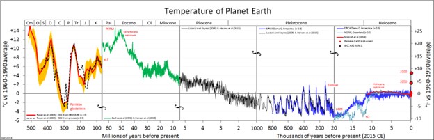
Pre-oil global warming (GW), a compendium from experts (Fig. 1):
https://en.wikipedia.org/wiki/Cretaceous_Thermal_Maximum
Sun causing GW and sea level rising? NASA says not today (!):
https://climate.nasa.gov/faq/14/is-the-sun-causing-global-warming/
However, John Clauser, Quantum Nobel laureate, says climate models miss one key variable, clouds v. sunlight. Earth’s natural management is free. No taxes are needed, but maybe you might have to move a bit.
Good medium-term news for your IRA—Global fossil energy consumption and global needs to grow robustly until 2028:
https://www.iea.org/news/growth-in-global-oil-demand-is-set-to-slow-significantly-by-2028
I prefer to think that we will adapt, perhaps too well, to our environment, political or physical.

- Coiled tubing drilling’s role in the energy transition (March 2024)
- The reserves replacement dilemma: Can intelligent digital technologies fill the supply gap? (March 2024)
- The last barrel (February 2024)
- Oil and gas in the Capitals (February 2024)
- What's new in production (February 2024)
- First oil (February 2024)

