What's new in exploration
The U.S. tax cut bill gives new hope to the Arctic. And, look at exploration’s future being discussed at this year’s OTC, finally!
BP—after spending tens of billions of dollars in liability on one flowing exploration well—and Petrobras—a long-time leader in deep water exploration—have agreed to work together, to combine money and talent to further explore Brazil, which seems to be better-wired for investment than they were just a few months ago. This is encouraging, but I remember getting nationalized by them in 1986.
We drill thousands of feet deep, aiming from a spot at the surface precisely measured to the “foot” from a satellite map to somewhere X,Y, Z in the sub-surface. We believe we have a TD location, but it often was determined with reflection seismic technology, capable of plus or minus 500 ft, x, y down there, and Z of no better than 20 ft, approximated from a theoretical 100-ft derivation. Drilling surveys tell us you never TD from a true vertical position off your map— that is normal.
You convince yourself that you know more about the bit destination, only because sample theory statistically beats signal theory. CDP, 2D/3D, surfaces, “events”, “faults”, migrations—time or depth—are only theoretical positioning methods, statistically visualized for interpretation back to some better geologic understanding. Do you think it’s time to go back and resurvey those almost-successful producers and near-miss discoveries? The shale guys did.
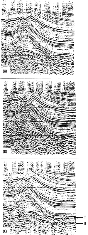
Great progress. My point is look at what advancing 3-D versus 2-D has accomplished. We miss this significance today, when we extract a 2D line from a 3D volume. I show a drilled example on this page, from the AAPG website. The three images are the same recorded data over the exact same positions. One (a) is not-migrated 2D. I was told by my Conoco managers in the 1980s that they found a lot of oil on “unmigrated” data and did not need “reprocessing.” They were not finding any that day. In the second image, the same line (b) with 2D migration is a theoretical calculation to move seismic events closer to their true subsurface position. This method, a big advance, only uses the data under the surface seismic position directly under the “in-line” of a single “cable.”
The third Image (c) is a 3D migration of the same, but using acoustic energy thought to be from cross-line or out-of-plane spaces recorded on all cables from a single shot. The distance to that out-of-plane, or cross-line is vital. The farther away, the less resolution and confidence. We have drilled a lot on less.
While I worked on 3D processing theory in the early 1970s at GSI/TI with holograms, it took oil companies a long time to appreciate the cost benefit of 3D. Marathon International performed its first, when production engineers paid for a survey in the late 1980s. 3D made a big difference to our geologic understanding offshore Indonesia. Same for microseismic. Grechka of Marathon claims forefront microseismic advances—“the remarkable high resolution of seismic images obtained in both [shale] case histories is unquestionable.” The Leading Edge, October 2017, p. 822, Special Section: Microseismic. Maybe—but understand, we need more surveys.
The difference between 2-D and 3-D seismic methods is more where, or how, seismic data were recorded. Resolution depends on surface coverage and acoustic frequency recorded. X,Y’s for each 3D marine sensor are still assumed at each shot position. The way in which migration is performed to “true” 3D imaging is merely a statistical process, based on where a common mid-point in the subsurface should be—they are never actually met. I am often amazed that this technology works at all.
If you are working on data taken or processed more than 10 years ago, you are seriously handicapped in imaging the subsurface, whether that is for exploration or reservoir determinations. Oil companies are updating their older data. This is an inexpensive time to invest in your data library. I am. WesternGeco is keeping theirs. ![]()

- The reserves replacement dilemma: Can intelligent digital technologies fill the supply gap? (March 2024)
- Prices and governmental policies combine to stymie Canadian upstream growth (February 2024)
- U.S. producing gas wells increase despite low prices (February 2024)
- U.S. drilling: More of the same expected (February 2024)
- U.S. oil and natural gas production hits record highs (February 2024)
- What's new in exploration (January 2024)

