Collaborative well engineering delivers record horizontal appraisal in Barents Sea
The industry’s continued advance into new, often remote, frontiers is changing the paradigm for how E&P companies engineer projects that present high degrees of complexity, risk and cost. Upfront planning and collaboration between service providers and operators, to develop integrated, customized solutions for the life of the well, strengthens the ability to meet key objectives in fields outside the conventional operating envelope.
The involvement of service companies early in planning and well-design enables operators to not only implement fit-for-purpose tools, technologies and expertise, but also to optimize processes and workflows, ensuring that all project phases are executed successfully. In a price-challenged market, this can translate to high-level efficiency and cost-effectiveness versus the traditional fragmented system, where planning and design are done by the operator, and multiple-service providers execute an array of services with often disparate technologies.
Given this consideration, OMV Norway applied a collaborative approach to deliver a challenging, shallow, horizontal appraisal well in the Barents Sea, integrating a broad portfolio of several specialized drilling, reservoir characterization, and well testing techniques. Through a close collaboration with Schlumberger, including early engagement in planning and well design, OMV engineered a customized workflow for every step of the process, successfully meeting multiple objectives.
During the nine-month planning phase, OMV and Schlumberger examined the trade-offs, advantages and contingencies involved in carrying out various aspects of the project, including casing design, bottomhole assembly (BHA) runs, and a challenging, high-dogleg trajectory at a shallow vertical depth. The appraisal well’s success generated valuable information about the field’s reserve potential and economic viability, and has opened up new opportunities in the Barents Sea.
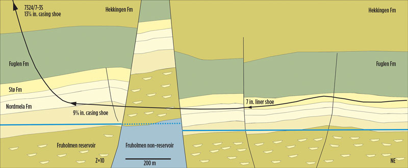
Located in the remote, highly-faulted Wisting field of the Arctic region of the Barents Sea, the well is the world’s northernmost horizontal well, at 73° N latitude, 217 mi from Hammerfest, Norway. Vertical exploration and appraisal wells that had been drilled previously in the region indicated that horizontal wells would be necessary to develop the reservoir—which is situated between 787 ft and 886 ft below the seabed—more economically.
To that end, OMV Norway wanted to prove the drillability of a shallow, horizontal well, landing it below 1,312 ft of water and roughly 820 ft below the seabed—a record for subsea wells—and geosteering for 4,593 ft across the multiple fault blocks. The operator also wanted to perform a well test in a 1,509-ft fault block to verify horizontal productivity and gain appraisal information, including reservoir data in new blocks, estimated oil-water contact, and geomechanical properties. The undertaking was notable, because horizontal well testing is not common, due to increased complexity.
CUSTOMIZED WELL ENGINEERING STRATEGY
The reservoir’s shallowness, along with lessons learned from earlier wells drilled at Wisting field, clarified that the most critical project aspect centered on achieving an average dogleg severity (DLS) of 9°/~100 ft, to build an angle from 0 to 90° inclination over a vertical interval of 820 ft. Since the hole configuration needed to accommodate the drill stem test (DST), OMV and Schlumberger screened various casing and string designs for an optimal solution. The well plan had an exploration target in the build section before starting the long horizontal section in sandstone that would be geosteered. Multiple fault blocks would be drilled through, while measuring formation pressure and evaluation data from logging-while-drilling (LWD).
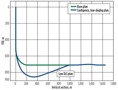
OMV Norway launched its planning in April 2015, involving Schlumberger at the outset to develop a customized, integrated strategy for meeting objectives more safely. This involved identifying and outlining such challenges as equivalent circulating density (ECD), hole cleaning, and torque-and-drag inherent to shallow horizontal drilling. Since the shallow landing point classified the well as an extended-reach drilling (ERD) project, ERD experts conducted a feasibility study to identify risks and mitigation methods, and developed contingency plans for the difficult trajectory, sidetracking, and a relief well plan, Fig. 1.
A 3D geomechanical model of the subsurface was created, using the Petrel E&P software platform. Horizons and faults identified from seismic surveys were used to create the subsurface structure, while well logs, including azimuthal sonic, were combined with core test results to characterize the mechanical properties in each formation. Stresses were then calculated over the whole field, allowing for the influence of bedding inclination, faulting, pore pressures, and mechanical property variations.
Drilling events, leak-off tests and other measurements from existing wells were used to confirm the model was calibrated correctly. The model results enabled the drilling conditions to be predicted along any proposed well trajectory, including the choice of a stable mud weight. This was especially valuable for the shallow horizontal well, where the mud weights, casing points and cementing plans for each section had to be designed carefully, to ensure stability of the well throughout all operations, Fig. 2.
A drillability study examined rock strength, pore pressure, high-angle drilling, the BHA build, and formation response and hole-opening. Schlumberger used a drillbit optimization system, based on the Techlog wellbore software platform for real-time geomechanics, to analyze offset wells, define formation strength, anticipate drilling parameters, and simulate BHA build tendencies. Because the well’s angle build needed to start early, to keep the DLS requirement low, a shortened conductor was selected to provide the shallowest possible kickoff point from the vertical surface hole. This was facilitated by a conductor anchor node (CAN) with a pre-installed conductor, with sufficient capacity to handle the required loads.
DETERMINING SUFFICIENT BUILD RATE
The key drilling challenge was identifying the sufficient build rate, especially at the start of the pilot section, to produce the necessary dogleg. A high-angle drilling strategy study, which included a build rate decision tree, summarized thresholds for various depths and determined that an average build rate of 9°/~100 ft would adequately build the angle, to ensure that the well was landed shallow enough. But it was not too shallow, so as to create a trajectory curve that would be too high to prevent installation of the well testing string. Multiple simulations were conducted to anticipate the build tendency ranges from various BHAs in each formation, at all inclinations and in relevant hole sizes; predict limits on ECDs while drilling and cementing; and support casing and cementing design. The simulations indicated that a build rate up to 12°/~100 ft to 13°/~100 ft was feasible in the formation with a sliding BHA.
It was critical to develop a drilling fluid system that delivered maximum formation stability; inhibited the swelling of reactive clays; prevented hydrate buildup inside the fluid; and accounted for ECD in the horizontal section. A fluid qualification study encompassed formation intrusion, shale stability, loss strategy, and gas diffusion. All key mud parameters were checked according to the low well temperature (around 63°F at the landing point), to make sure that the correct rheology data could be used in all simulations. Drilling fluid and cementing engineers designed a lost circulation material (LCM) plan for the full drilling operation, from spud to total depth (TD). The team placed special focus on ensuring that neither the fluid nor the LCM would cause formation damage, especially in the horizontal section, which crossed several faults.
Formation damage and flow permeability testing on core samples from the previous offset wells, and on ceramic discs that mimicked the reservoir properties, was performed for oil-based mud (OBM), with anticipated concentrations of LCM.
The well was spudded in January 2016, with a 26-in. surface hole drilled below the CAN, fitted with a 36-in. conductor. The TD of this section was designed to support 1.20 specific gravity (SG) OBM, so as to optimize directional drilling and avoid hole stability issues. The hole, with 20-in. casing, was drilled to 1,804 ft, MD. Due to a formation change at the 20-in. shoe, the subsequent section could not be drilled with the planned 1.2 SG mud weight (MW). In consultation with the 3D geomechanical modeling, which indicated borehole stability down to 1.1 SG, it was decided to reduce the MW, accordingly.
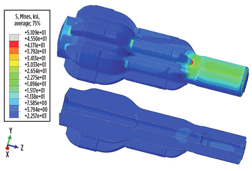
To safely navigate the dogleg section, the team implemented a two-run strategy of drilling a short 12¼-in. hole before opening the pilot section to 17½ in. Opening the hole at this DLS posed several risks, including accidental sidetracking and tool fatigue or failure. After performing hundreds of simulations with the Schlumberger i-DRILL integrated dynamic system analysis service, which uses predictive modeling to minimize tool vibration while drilling, the team determined that implementing a staged hole opener (SHO) with a straight mud motor would achieve the most stable solution, Fig. 3.
From the 20-in. casing, the 12¼-in. hole was drilled, using a mud motor with a bent housing, sliding the entire 656 ft and using a 1.10 SG OBM. A DLS of more than 12°/~100 ft was achieved, which, per the high-dogleg drilling strategy document, triggered a change of the motor bend before finishing the section. The SHO, with the straight downhole motor on top for rotation, opened the 12¼-in. hole to 17½ in., in a single run at a continuous build rate of 9°/~100 ft, the most aggressive build rate opening ever undertaken for that hole expansion range. To prevent an accidental sidetrack, a bull nose was positioned ahead of the SHO.
NAVIGATING THE DOGLEG
The 17½-in. section was opened successfully and landed at a TD of 2,234 ft. Standard 13 3/8-in. casing was set, with the casing shoe cemented on top of the first reservoir.
The 17½-in. section landed shallower than planned, due to the increased build rate in the section's upper portion. This enabled the operator to drill the main 12¼-in hole with a less aggressive bend, so the BHA could be rotated. The planned section TD was recalibrated to match the new trajectory, maintaining the original goal to secure the build section, from 54° to nearly horizontal. The 9 5/8-in. casing was run to TD with no issues.
The drilling team then moved into the 8½-in. horizontal section, using a full BHA and a rotary steerable system, which, because of the decreased DLS in the previous section, was also used to drill out the 9 5/8-in. casing shoe. This eliminated a dedicated drill-out run, reducing time and operational complexity.
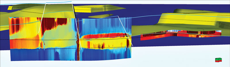
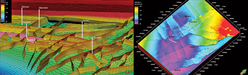
Reservoir mapping and LWD tools in the string facilitated optimum well placement. OMV Norway drilling and subsurface teams, along with a Schlumberger well operations analyst, used surface logging tools to monitor, interpret, and predict the well status using real-time data. The GeoSphere reservoir mapping-while-drilling service indicated that the reservoir was thicker and more heterogeneous than estimated—information that enhanced geosteering and well reservoir evaluation, Fig. 4.
The LCM plan of circulating third-party coarse fibers through a circulation sub in the string when encountering loss zones was effective initially; however, losses re-occurred, as new formation was drilled and sub-seismic faults were encountered. Due to constant dynamic losses, a decision was taken to change the OBM to a specially-designed water-base mud system. After crossing one of the last major faults, the section was secured with a 7-in. liner, and drilling continued with the contingent 6-in. BHA.
The contingency involved using the STARGLIDE ROP-enhancing lubricant, developed by M-I SWACO, a Schlumberger company. The lubricant reduced torque substantially, thus enabling the well to be drilled to TD at 7,723 ft, MD, with no major issues, and a 5-in. liner to be set. To achieve the targeted ROP of ~100–196 ft/hr for the significant BHA in this section, the DigiScope slimhole measurements-while-drilling service supplied enhanced signal strength to transmit data to the surface, for real-time reservoir monitoring and geosteering.
The challenges encountered in this section taught an important lesson. While the porous sandstone reservoir did not generate losses below a certain ECD threshold, the faulted areas were significantly weaker, requiring robust LCM material. Use of alternative, specialized drilling methods, potentially such as managed pressure drilling, could also deliver a solution for this scenario.
The 1,969-ft interval provided adequate length for placing 1,509 ft of perforations for the DST. The operator achieved a successful well test at a flow of up to 5,000 boed, with good production and flow properties, gaining the necessary information for reservoir potential. The well was then plugged and abandoned.
RESERVE ESTIMATES INCREASED
The three-month drilling operation delivered valuable data for both future development and exploration in the Barents Sea, especially for wells in shallow reservoirs. The project also confirmed that doglegs up to 12°/~100 ft can be achieved in a large-hole size as shallow as 197 ft below the seafloor. Importantly, the well enabled the operator to refine the estimates of reserves in place upwards by hundreds of millions of barrels, and also increase the estimates of recoverable reserves, approximated between 200 MMboe and 500 MMboe. The project met all key well objectives on time, and within budget, with no HSE issues.
As the heel of the well was landed in a field section where there had been no previous exploration wells, the operator also achieved with one well what typically requires two—an exploration well on the west side of the reservoir, with the horizontal well intersecting faults that will produce from the other side. This further enhanced the project’s return on investment.
The collaborative approach, starting with Schlumberger’s early involvement in the planning process, set a new well design standard for developing the field—an example to other operators venturing into this and other complex frontiers. Ultimately, this complex operation was executed by just three key players—the operator, the drilling contractor, and the service provider—in a streamlined process where integrated, unified teams worked together to achieve common, jointly-defined goals. Moreover, the three-party approach simplified the accountability matrix without creating ambiguity and misunderstanding. The integration model driven by the operator and service provider complemented each other’s capabilities, eliminating duplication of effort; compensated for shortages of internal expertise; limited reservoir uncertainties; shortened cycle times; and maximized drilling schedules.
By implementing a broad portfolio of fit-for-purpose tools and technologies, and expertise from multiple disciplines, OMV Norway was able to develop comprehensive workflows and processes, including critical contingency plans, to efficiently, cost-effectively and more safely deliver a first-of-its-kind horizontal appraisal well from start to finish. ![]()
ACKNOWLEDGMENT
This article is based on SPE paper 184654, “Transformation of mindset: Cost-effective collaborative well engineering & operation delivers record horizontal appraisal well in the Barents,” by D.H. Breivik, G. H. Hollinger, O.H. Myrvoll and S. Trauner, OMV (Norge) AS; and C. Dupuis and A. S. Wendt, Schlumberger.
- Applying ultra-deep LWD resistivity technology successfully in a SAGD operation (May 2019)
- Adoption of wireless intelligent completions advances (May 2019)
- Majors double down as takeaway crunch eases (April 2019)
- What’s new in well logging and formation evaluation (April 2019)
- Qualification of a 20,000-psi subsea BOP: A collaborative approach (February 2019)
- ConocoPhillips’ Greg Leveille sees rapid trajectory of technical advancement continuing (February 2019)

