Marine multi-measurement system improves imaging quality, exploration efficiency
Since its launch in 2012, IsoMetrix marine seismic technology has been deployed successfully around four continents.
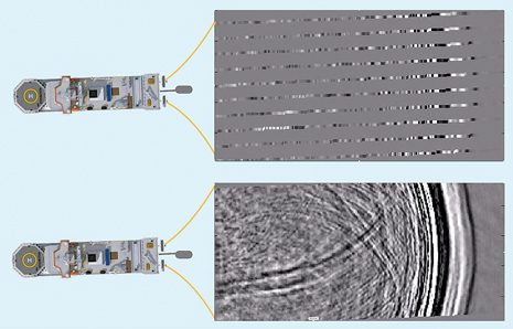
Cost control is a key driving factor in today’s oil and gas exploration environment, and the marine seismic market is no exception. There are many examples of seismic technologies that have delivered value and reduced overall exploration cost to the industry. The transition from 2D to 3D in the 1980s is widely recognized as one of the most significant contributors to improved drilling success rates.Recent developments—such as fanned or widely spaced streamer spreads, continuous line, and simultaneous shooting—have targeted improved efficiency in seismic acquisition. Meanwhile, new approaches—including broadband, rich azimuth, and coil shooting acquisition—combined with advanced processing and imaging algorithms, have driven major advances in the quality of subsurface models derived from surface-acquired seismic data. Historically, these improvements have come in phases, and, over the last few years, quality has often, understandably, taken precedence over efficiency. We are now re-entering a period, where access to the most cost-effective technology is paramount; however, the technical challenges faced by multidisciplinary asset teams continues to grow. The potential downside of compromising on seismic data quality can be significant, both economically and in terms of operational exposure. So the question to be asked becomes, “Can we get the best of both worlds; reliable high-fidelity seismic data within a reasonable budget?” The answer lies in a new generation of multi-measurement, marine seismic technology that enables both efficiency and quality benefits. It delivers high-fidelity data while also enabling significant operational efficiencies for acquiring seismic data, suitable for exploration, drilling hazard prediction, reservoir appraisal, reservoir development, and production monitoring. TEMPORAL AND DEPTH RESOLUTIONSeismic data deliver spatial continuity of imaging across a wide geographic area, but they have always, inherently, delivered lower resolution, compared to downhole measurements, such as formation density and acoustic impedance. In seismic data, depth resolution requires resolution in two-way acoustic travel time, which is dependent on the temporal frequency bandwidth input to the subsurface, which is subsequently recorded back at the surface. In most marine environments, towed-streamer geometries are, usually, the most economically viable solutions for the acquisition of large, 3D seismic surveys. They are, currently, the only option for both deepwater and large areas. However, conventional towed-streamer techniques suffer from the “ghost” effect, which interferes with the seismic bandwidth of primary seismic reflections. This interference is due to the reflection of the up-going seismic wave field, recorded by the pressure sensors after reflection at the sea surface, a short distance above the streamers. In addition to the receiver ghost, there is a source ghost—the result of interference between the down-going seismic wave field, with its reflection from the sea surface above the source. These ghost reflections result in “ghost notches” in the frequency spectrum, which are low amplitudes in particular frequency bands. The notch frequencies are dependent on the source and streamer depth. Ghost notches in the seismic wavelet lead to loss of resolution in the seismic image, increasing uncertainty in interpretation and subsurface models. Conventional towed-streamer, marine seismic acquisition systems deploy sources and streamers at shallow depths, typically between 6 m and 10 m. This configuration enables recording of the high frequencies needed for resolution, but attenuates the low frequencies needed for stratigraphic and structural inversion. Shallow towing also makes the data more susceptible to environmental noise, such as that caused by waves, swell and wind. The towing of sources and streamers at deeper depths enhances the low-frequency content and can increase the signal-to-ambient-noise ratio (S/N); however, it attenuates the high frequencies. Several streamer technology and deployment solutions, coupled with new processing algorithms, have been developed to overcome the ghost effect, including using sets of “over/under” streamers—towed simultaneously at different depths—and a broadband slant streamer approach, both of which have proved robust and effective in a range of 2D and 3D applications. SPATIAL RESOLUTIONIn addition to temporal resolution, achieving truly 3D, high-resolution imaging of complex subsurface structures also requires adequate spatial sampling. Hydrocarbon reservoirs require trap closure, in all directions, and are intrinsically 3D structures; therefore, spatial sampling should be adequate in all directions. Over/under, slant, and other streamer technology and deployment solutions help to address limitations in temporal bandwidth, but they do not deliver adequate spatial sampling in all directions. 3D surveys are, typically, acquired by a vessel equipped with between eight and 16 streamers, towed 50 to 100 m apart, each 3 to 8 km long. Each streamer contains hydrophone sensors, and spatial sampling of the data recorded along each streamer (inline) can be as fine as 3.125 m; however, the much greater distance between adjacent streamers means that sampling in the orthogonal (cross-line) direction can be 16–32 times sparser. Hydrophones detect seismic energy, in the form of pressure changes under water, and are omnidirectional, which means that they cannot detect the orientation of seismic wave fields and are, thus, only point-pressure amplitude measurements. Such coarsely sampled data cannot capture the whole 3D wave field, which limits its ability to accurately image the subsurface. ISOMETRIC MARINE SEISMICDuring 2012, WesternGeco launched its IsoMetrix marine isometric seismic technology, which enabled true measurement of 3D seismic wave fields, using towed streamers. This capability is the result of an extensive 10-year research and engineering program that was the largest, single engineering project ever undertaken by Schlumberger. The new technology delivers high-fidelity point-receiver seismic data while overcoming spatial, wave-number bandwidth compromises that have limited previous marine seismic acquisition methods.6 The result is a reliable, continuous measurement of the full, seismic wave field in all directions, Fig. 1.
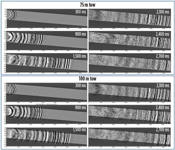
Isometric 3D sampling is enabled by a new generation of a multimeasurement towed-streamer system. This uses point-receiver technology that combines hydrophones with calibrated, point-receiver, micro-electromechanical system (MEMS) accelerometers that measure the full particle acceleration of the up-going and down-going seismic wave field. Direct measurement of the vertical and cross-line particle acceleration gradient enables simultaneous 3D deghosting and unaliased reconstruction of the pressure wave field between the streamers. For each seismic shot, the measured pressure (P), vertical (Z), and cross-line horizontal (Y) components of the pressure gradients are combined after appropriate noise attenuation. The PYZ combination is done through a data-dependent processing technique called generalized matching pursuit (GMP). The GMP scheme provides a spatial de-aliasing capability, up to much higher orders than predicted by basic signal sampling theory. It also simultaneously deghosts the data in a true 3D fashion.5 The source ghost is addressed by use of a notchless seismic source developed by Schlumberger. Fine isometric sampling—in both cross-line and inline directions—makes the data suitable for use in exploration, and a wide variety of other interpretation and modeling applications, such as high-resolution, near-surface imaging, deep reservoir characterization and 4D reservoir monitoring. VALIDATING THE TECHNOLOGYWave field reconstruction calculates the up-going wave field between the streamers. This approach may lead to the question of whether the reconstruction is an adequate substitute for real measurements. To address this question, an experiment was performed to independently assess the quality of the reconstruction achieved by the GMP algorithm, on multi-measurement streamer data.3 A test line was acquired with 75-m streamer spacing, except for the central streamers, which were separated by 37.5 m. This configuration enabled the selection of one streamer as a witness streamer, for which the recorded data were not used during the wave field reconstruction process. The seismic wave field was reconstructed at the exact witness streamer location, and the results were compared with the actual wave field recorded by the streamer. This allowed qualitative and quantitative evaluation of the reconstructed wave field, at a point mid-way between the streamers—the location where any reconstruction error would be the largest. The results showed a strong similarity between the recorded and reconstructed wave fields throughout the section. Spectral analysis showed a good match up to 70 Hz in the shallow section and at target level; an excellent spectral match was observed in the entire signal bandwidth. MORE EFFICIENT EXPLORATIONEfficient marine 3D seismic exploration means doing more in less time, which equates to towing more streamers, further apart. However, the pursuit of this goal can often incur quality compromises and/or operational risks. Spreads comprising 14 or more streamers are becoming increasingly common, as are streamer separations of up to 200 m. Although a 200-m-spaced spread of conventional streamers may provide seismic data quality fit for rank exploration, subsequent exploration and appraisal drilling programs will, most likely, require a higher resolution re-shoot—and the cost of acquiring another survey is far from insignificant. Experience, to date, confirms that the combination of multi-measurement streamers and the GMP algorithm is powerful in reconstructing and deghosting the seismic wave field, even in the case of severe cross-line aliasing. This means that fine spatial sampling can be achieved with relatively wide streamer separation, which maximizes the productivity—and the cost-efficiency—of 3D exploration seismic surveying without compromising data quality. To investigate the effect of increasing streamer separation on the quality of the reconstruction for real seismic data, a 3D test data set was acquired in the North Sea, using a multi-measurement streamer.4 An initial acquisition was carried out with eight streamers, at a 75-m separation. The line was then repeated with an increased streamer separation of 100 m over the same pre-plot line. A standard preconditioning processing flow was applied to the data prior to reconstruction, primarily to address residual noise on the measurements. The data were then input into the GMP workflow, and the wave field was reconstructed on a 6.25-m by 6.25-m surface grid. Figure 2 shows the reconstructed pressure wave field, at various depths, for both the 75-m and 100-m datasets. Note that the 100-m dataset covers a larger subsurface area with the same eight streamers. As well as visual comparisons in a number of domains, a detailed analysis was carried out to evaluate the reconstructions. This analysis demonstrated that the reconstruction quality was comparable for both 75-m and 100-m streamer separations. This provided confidence that it is possible to relax the streamer separation—for example, from 75 m to 100 m—and still reconstruct the wave field to the finer cross-line sampling, to a quality that is acceptable for seismic exploration. This confirmed that the multiple measurements of pressure and pressure gradient allow more efficient acquisition configurations, without compromising cross-line sampling. Towing streamers further apart also has benefits for operational safety, as with increased separation, there is a reduced chance of streamers becoming entangled.
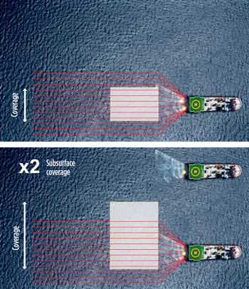
Further efficiency increases can be achieved through multi-vessel operations. Figure 3 illustrates a configuration, whereby the addition of a second vessel doubles the subsurface coverage, but without compromising on spatial sampling that would otherwise impact the same approach with conventional technologies. This configuration, typically, results in a 30% reduction in total acquisition duration, enabling faster decisions; less operational and environmental exposure; and it can also help compress very large exploration surveys into single acquisition seasons. The additional source vessel is often a cheaper source vessel, costing significantly less than a 3D seismic vessel.
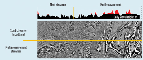
INCREASED WEATHER WINDOWOcean waves and swell create noise in the measurements made by seismic sensors, particularly when streamers are towed close to the sea surface. Conventional seismic surveys are prone to significant non-productive time (NPT), due to adverse weather and sea states. Due to the 3D deghosting capability, the new multi-measurement streamer system can be towed deeper than conventional systems, allowing for an extension of the acquisition window, without compromising data resolution. Figure 4 shows a time slice straddling two surveys from the Barents Sea. The top part was acquired with a broadband, point-receiver, slanted cable system; the lower half was acquired the following year with the multi-measurement streamer. For this test, the new dataset was processed by using only the pressure wave field and vertical pressure gradient to match the first, as closely as possible. The multi-measurement data were acquired in significantly worse weather conditions than the first dataset, as shown in the graph of wave height. The weather conditions were such that a conventional crew, which was operating nearby, was forced to shut down operations during the same acquisition period, while the multi-measurement system continued to record high-quality data.
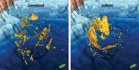
MULTI-PURPOSE SEISMIC DATAWhile this article focuses primarily on the ability of the new multi-measurement streamer to enable exploration efficiencies, there are also potential benefits for subsequent reservoir appraisal and development. Multi-measurement data were acquired over the Bruce field area in the North Sea, and qualitative and quantitative interpretation comparisons were made against an equivalent broadband, hydrophone-only dataset derived as a subset of the original measurements.1 Inspection of the two volumes indicated uplift in the multi-measurement dataset at multiple levels, from seafloor to the reservoir. High-resolution images in the shallow section show the multi-measurement data fidelity, and indicate the potential for seismic data suited for geohazard identification. In the Palaeogene overburden, understanding of the intricate structural geometries of turbidites and sand injectites was enhanced, using the multi-measurement data, which demonstrated good spatial imaging of fine-scale structures with complex 3D orientations. Figure 5 compares images derived from conventional data versus data from the multi-measurement system for some intricate sand injectites, which are commonly associated with reservoir units in the North Sea. The new technology resolved these complex structures, in all directions, in a way consistent with the expected morphology of such features.
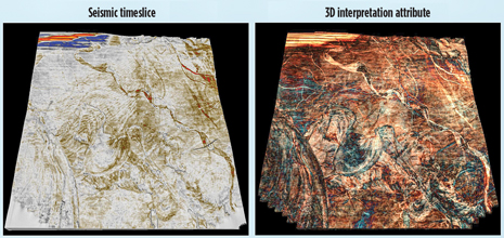
By contrast, the hydrophone-only conventional equivalent indicated only some elements of the injectites, leading to potential interpretational bias. Across the reservoir interval itself, improved continuity in the pre-stack inversion cube from the multi-measurement data suggested better separation of signal from noise, coupled with low-frequency content to deliver close to absolute impedance without low-frequency model input. 4D REPEATABILITYThe GMP algorithm can compute the wave field, at any desired position, within a spread of streamers. This ability contributes to an unmatched level of repeatability in 4D (time-lase) projects, which map subtle changes in a reservoir’s seismic response. The 4D method can guide reservoir management decisions, identify flow barriers and locate untapped compartments suitable for infill drilling. 4D projects involve acquiring time-lapse 3D surveys from before and during a reservoir’s productive life. Differences in the measurements from one survey to the next can indicate changes in pressure or fluid content. Changes in the seismic response of a reservoir can be masked by differences in the way that the data have been acquired from one survey to the next, particularly positioning differences. The ability to compensate for positioning differences between repeat surveys, using data selected from the reconstructed wave field, has been demonstrated using data acquired in repeat surveys over the same area of the North Sea.7 DETAILED INTERPRETATIONIn 2013, a multi-measurement streamer survey was acquired, covering a full-fold area of 686 km2 off the west coast of South Africa.2 The survey objective was to improve confidence in siting appraisal and development wells, despite being acquired with 100-m streamer separation, which is, typically, only used in exploration surveys. Analysis and preliminary interpretation of the processed data volumes showed a broadband dataset that enabled detailed structural and stratigraphic interpretation. Receiver-side deghosting benefited from a flat, deep tow configuration, and contribution from the accelerometer measurements for frequencies below 10Hz. The near surface was expected to contain extensive shallow channeling, below which there is a chaotic seismic zone associated with rapid deltaic deposition. Figure 6 is a time slice from the time-migrated volume, extracted along a dipping interpretation horizon in the overburden. This shows good indications of characteristic stratigraphic features less than a second below the seafloor, with evidence of complex, intertwined and overlapping channels, and faulting, across the whole area. Also shown is the equivalent time slice extracted from a volume attribute, based on a color blend of the various frequencies and the envelope attribute to enhance particular seismic events along a shallow, dipping interpretation horizon, which further reveals the complex nature of the shallow channels.
Since its launch in 2012, the new, multi-measurement towed-streamer system has been deployed successfully offshore four continents. A rapidly growing number of projects and six petroleum basins have confirmed its ability to deliver improved exploration efficiency, but also enhanced quality imaging for reservoir appraisal, development and drilling hazard identification. The technology offers more cost-effective marine seismic data acquisition, while delivering 3D datasets suitable for multiple purposes during a reservoir’s life. REFERENCES
|
- Advancing offshore decarbonization through electrification of FPSOs (March 2024)
- The reserves replacement dilemma: Can intelligent digital technologies fill the supply gap? (March 2024)
- Subsea technology- Corrosion monitoring: From failure to success (February 2024)
- What's new in exploration (January 2024)
- Dallas Fed: E&P activity essentially unchanged; optimism wanes as uncertainty jumps (January 2024)
- Driving MPD adoption with performance-enhancing technologies (January 2024)
- Applying ultra-deep LWD resistivity technology successfully in a SAGD operation (May 2019)
- Adoption of wireless intelligent completions advances (May 2019)
- Majors double down as takeaway crunch eases (April 2019)
- What’s new in well logging and formation evaluation (April 2019)
- Qualification of a 20,000-psi subsea BOP: A collaborative approach (February 2019)
- ConocoPhillips’ Greg Leveille sees rapid trajectory of technical advancement continuing (February 2019)

