 |
| The use of real-time, spectral azimuthal, gamma ray (SAGR) logging methods while drilling horizontally enhanced reservoir understanding in Eastern Siberia. |
|
To stay within optimal reservoir characteristics in Russia’s Verkhnechonskoye oil and gas condensate field, geosteering is challenged by complex geological conditions. The field’s main reservoir section is difficult to understand, and building a detailed and accurate petrophysical model describing the mineral composition of the section is a significant task. In addition to eight neighboring exploration blocks, the field is one of a handful of high-priority Rosneft projects in Eastern Siberia.
The use of real-time, spectral azimuthal, gamma ray (SAGR) logging methods, while drilling horizontally, enhanced reservoir understanding. Timely identification of highly radioactive and producing gravelites informed geosteeering, to accurately place the wellbore within the most productive zones. Since the initial application in 2012, 11 horizontal wells in the field have been drilled with geosteering systems, using the SAGR logging-while-drilling (LWD) sensors.
GEOLOGIC CHALLENGES
Verkhnechonskoye field, northeast of Irkutsk, is the largest field in Eastern Siberia. The 1,481-sq-km field was discovered in 1978, and its active development phase started in 2007.
While there are several commercially producing horizons, the field’s main oil reserves are confined to the VC1 and VC2 formations. The two formations are lithologically represented by clastic sedimentary material, with grain sizes ranging from fine-textured lutaceous fractions to gravelite of mainly quartz or quartz-feldspathic composition.
The VC2 formation has beds of gravelites with good permeability of 900 mD to 1,000 mD, and porosity of 16% to 18%. Gravelites are also present in the VC1 formation, but their permeability and porosity is worse; porosity is 6% to 12%, and permeability is typically in the 0.1-mD-to-100-mD range, although it may sometimes reach 1,000 mD. This permeability and porosity decrease results from rock salinization. Sandstones of VC1 and VC2 formations are anisometric, with sand sizes varying from very fine to very coarse. The cement ranges from film to porous-film, and is clayey and sometimes carbonaceous, and/or sulphate and asphaltic.
The distinctive feature of reservoir rocks of Verkhnechonskoye’s horizon is nearly ubiquitous, but very non-uniform, salinization. In some zones, halite content in the pore space increases to result in complete loss of permeability and porosity. In addition, individual rock varieties contain a significant quantity—as high as several percent of the rock volume—of accessory minerals, such as monazite and ferruginous elements that have abnormal physical properties of radioactivity and density.
SAGR REQUIREMENTS
A standard LWD suite of gamma ray, density, thermal neutron porosity and electromagnetic tools was used to build an accurate petrophysical model, describing the actual mineral composition of this section. However, the data could not provide detailed and accurate identification of accessory minerals with abnormal properties. In addition, poor density differentiation between clays and saline sandstones requires determination of the geologic structure, to be based on azimuthal density images.
The search for a solution led to using spectral gamma-ray logging, based on a three-component analysis—potassium, uranium and thorium (K, U, Th)—of the rock. Wireline spectral gamma-ray logging was performed in open hole, but the approach lacked critical timeliness. Real-time, wireline-quality spectral gamma-ray logging data, obtained while drilling, provided more current data for building an accurate petrophysical model, and enabled faster geological decision-making.
This real-time logging capability was achieved with a unique SAGR technology. Azimuthal measurements using Weatherford’s Spectral Wave tool make it possible to identify reservoir rock lithology that is problematic, or impossible, with conventional logging techniques. The tool enables the construction of higher-precision models through determination of the K/U/Th percentage to update the mineral composition of reservoir rocks. The real-time gamma ray images also provide data for geosteering.
In Verkhnechonskoye, the tool enabled a range of tasks while drilling the horizontal section. Gravelite identification was performed through lithological stratification of the section. To define reservoir beds, the tool provided updates of rock lithotypes by K and Th content. It was also possible to identify mechanical facies to inform the hydraulic fracturing design. Qualitative clay typing was produced from potassium concentration curves.
GRAVELITES AND CRUSTS
Gravelites are one of the main potential drilling targets in the field, based on their permeability of 900 mD to 1,000 mD, and porosity of 16% to 18%. Gravelite is a medium- and coarse-grained sedimentary rock, whose clastic sediments are represented by clasts larger than 2 mm. The main mineral components are quartz, feldspar and mica. The rock has a high natural radioactivity, due to the accessory mineral monazite, which results in a level increase in the thorium content curve over the potassium and uranium curves.
Drilling in these gravelites is complicated by heavy lateral variation in the middle part of VC2 formation, where the gravelite’s stratigraphic thickness decreases and pinches out, and rock salinization and clay cement characteristics change. The beds of the gravelites are above a weathering crust, which increases the risk of penetrating the production interval. Weathering crust is a continental geologic formation formed on the earth’s surface, as a result of sediment source rock modification under the influence of liquid and gaseous atmospheric agents. These are impermeable rocks characterized by high density, growing resistance, increased potassium content, and very low permeability and porosity. The main composition of the weathering crust is dense, deflated and disintegrated granites, with clayey invasions along subvertical cavities and fractures. As a result, drilling these rocks leads to greater downhole equipment wear and resulting increases in well construction time.
GEOSTEERING SUMMARY
To address these challenges, the well’s horizontal section was drilled with a geosteering assembly comprised of a Triple Combo suite, plus a Spectral Wave tool and a rotary steerable system (RSS).
The Triple Combo suite measured dogleg severity and inclination, and logged electromagnetic, thermal neutron porosity and density data. The Spectral Wave tool is added to this assembly about 9.5 m from the bit.
The Spectral Wave sensor uses large, gain-stabilized scintillation detectors (three in the 6¾-in. tool and one in the 4¾-in. tool). The detectors are in pockets on the outside of the drill collar, which reduces the steel between the detector and the formation. The detector placement produces more accurate data by shielding the back and sides of the detectors, to reduce spectral smearing of the gamma ray energies and azimuthally focus the measurement.
Total gamma-ray log precision is enhanced by the high count achieved with the large detectors, even at fast drilling rates. This facilitates more accurate well-to-well correlation in geosteering applications. The tool also incorporates X-Y magnetometers to track the azimuthal position of the detectors as the tool rotates. This allows acquisition of 16-bin, azimuthal, total gamma ray data for real-time and recorded borehole images.
The first pilot testing of this logging suite, in combination with geosteering services at Verkhnechonskoye field, was performed during August 2012. Pre-job planning was essential to ensure that the response of the Spectral Wave tool in the given geological environment was understood. Data from an offset well was used to model the tool and electromagnetic responses for the lateral. The 8½-in. landing section, drilled and surveyed by another contractor, was also modeled to ensure correct positioning of the borehole, prior to the 6-in. drilling phase.
The geosteering was based on offset well correlation, real-time monitoring and active geosteering decisions. The main geosteering objective was to ensure that the well remained within the best reservoir characteristic subzones along the well path in the VC2 formation. This involved drilling approximately 800 m across the 6-in. section from the 8½-in. casing. VC2 was anticipated to be approximately 20 m thick and, based on available seismic information, appeared to be unfaulted with a gentle structure dip, approximately 1° to 3°, with expectations of structure rollover with depth.
Geological models were constructed to display information about the behavior of geological structure in real time. Three-component analysis of the Spectral Wave tool, in combination with Triple Combo logs, provided data on lithological stratification, reservoir porosity and permeability, the nature of radioactivity, and borehole images.
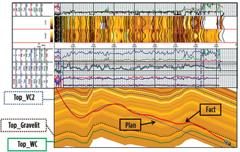
Based on this information, geosteering specialists determined the angles of the geological structure. In Fig. 1, Tracks 2 and 3 show the gamma ray image and density image. The short distance from the bit to the Spectral Wave sensor allows acquisition of timely image information on rock lithotype and the behavior angles of the geological structure. This allows geosteering specialists to confine precious wellbore footage to the pay zone (sandstone and gravelite), and target it for greater profitability.
 |
| Fig. 1. A geological model displayed information about the behavior of geological structure in real time. |
|
As shown in the model, the deviation of the actual borehole profile from the planned one is associated with the real-time information obtained by geosteering specialists while drilling, which enabled placement of the wellbore trajectory in the most productive part of the reservoir. Data interpretation of spectral LWD provided geosteering specialists and geologists with important information about reservoir porosity and permeability, and the qualitative lithological profile.
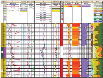
The petrophysical composite log in another well, Fig. 2, displays intervals of reservoir rocks with high radioactivity (Track 3—the red curve), the nature of which is related to thorium, a radioactive element. They are gravestones with good reservoir properties. In the composite log, gravestone intervals have a high level of thorium component (Track 5—the green curve), which mainly consists of such rock-forming minerals as quartz, feldspar and mica.
 |
| Fig. 2. The petrophysical composite log displayed intervals of reservoir rocks with high radioactivity. |
|
In the middle of the composite log, there is a non-reservoir interval, namely, a weathering crust, which consists of granite rocks. A reduction is seen in the overall background of natural radioactivity (Track 3—the red curve), and a reduced concentration of thorium component (Track 5—the green curve), but an increased potassium component (Track 5—the blue curve) due to the change of rock-forming minerals, namely, granites. Drilling this weathered crust rock results in high loads and vibration that leads to rapid bit wear and downhole equipment failure.
CONCLUSION
The main objective of keeping the well within the VC2 formation, and in the best formation subzones, was achieved through the use of spectral azimuthal, gamma ray logging methods. Remote determination of formation dip permitted the well to be steered within the VC2 layer at all times, and allowed for corrective action to be taken quickly, to minimize the interval out of the clean sand layer and to maximize the exposure to the most permeable zone.
Drilling results achieved approximately a 73% opening efficiency in the reservoir, with 120 m of the total 500 m drilled in gravelites in the lower section of the VC2 formation. In addition, a high rate of penetration, at an average of 40–50 m/hr, was achieved by minimizing the proportion of dense formation drilled. Use of the RSS drilling system ensured a smooth borehole trajectory, which allowed continuous rotation of the BHA, so that continuous azimuthal data could be delivered from the Spectral Wave tool. The result was exceptional trajectory control and real-time formation evaluation in a geologically complex formation. 
|


