JASWINDER MANN, CGG
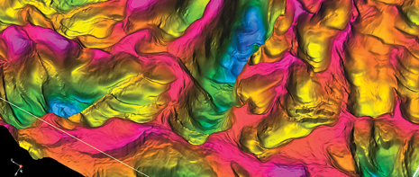 |
| An image of the top salt interpretation over CGG's Phase 6-A survey in the Santos basin, offshore Brazil (image courtesy of CGG). |
|
Compared to the neighboring Campos basin, the Santos basin remains fairly unexplored. Campos contains many discoveries within the pre- and post-salt sequence. Interest has now turned to the more frontier Santos basin, since the discovery of Lula oil field in 2006. With a string of subsequent discoveries, the Lower Cretaceous carbonate reservoirs have been established within the upper syn-rift and post-rift.
This article describes the benefits of broadband seismic technology through comparative examples from the Phase 6-A and 6-B surveys acquired by CGG within the Santos and Campos basins. Both datasets have been imaged, using Kirchhoff pre-stack depth migration (PSDM). The main difference is that the Phase 6-A conventional data have benefited from a full anisotropic PSDM sequence, while the Phase 6-B broadband seismic dataset is a fast-track isotropic volume.
WHAT IS BROADSEIS?
CGG’s BroadSeis is a complete marine broadband seismic data acquisition solution that combines low-noise Sercel Sentinel streamers configured to optimally curved, variable-depth, streamer profiles, with an average depth in excess of 40 m, and true 3D deghosting. The use of Sentinel streamers and very deep tow ensures an excellent signal-to-noise ratio, at the lowest frequencies (down to 2.5 Hz), to enhance deep, pre-salt imaging, and also to highlight layering and facies variations. The optimally curved streamer profile provides excellent receiver ghost notch diversity, for de-ghosting the data and accessing the widest bandwidth possible. This results in a clean, sharp seismic wavelet, with minimal sidelobes. This improves the resolution of events and allows more confident geologic interpretation, Fig. 1.
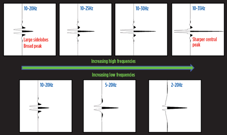 |
| Fig. 1. The positive effect of an increase in high and low frequencies—the central peak becomes sharper, and side lobes are significantly reduced. |
|
Broadband seismic also reveals a huge amount of detail in the shallow section, including high-resolution imaging of channels and thin reservoir beds, and differentiation between different facies types. Additionally, shallow hazards, such as gas pockets and methane hydrates, can be clearly delineated with broadband seismic data.
SANTOS BASIN
CGG’s multi-client database consists of a number of 3D PSDM surveys in the prolific pre-salt area, offshore Brazil, Fig. 2. The Cluster and Cluster Extension are conventional surveys that represent a combined area of over 42,000 sq km, and cover a number of large discoveries, including the multi-billion-barrel Lula oil field. Phase 6-A is a conventional survey of approximately 2,800 sq km, which includes the highly promising Libra discovery. The 14,000-sq-km Phase 6-B survey was acquired using broadband seismic over a largely unexplored, unlicensed part of the pre-salt region. The survey also extends to the northeastern portion of Campos.
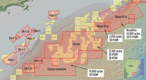 |
| Fig. 2. Location of CGG’s multi-client seismic surveys within the Santos basin, with reference to the Phase 6-B BroadSeis survey. |
|
The discovery of Lula field by Petrobras has paved the way for major interest in exploration within the pre-salt region. Within the pre-salt, a number of mega-sequences can be identified, with the oldest being a highly faulted, pre-rift basement, Fig. 3. These basement blocks impart a major influence on the deposition of pre-salt reservoirs. Lacustrine shales and mudstones make up the highly prolific source rock. Directly above are thick, syn-rift sediments, consisting of a lower and upper sequence. These sequences can be differentiated easily from each other, due to the changes in sediment character and orientation of sediments, along with the termination of extensional faults at the base of the post rift. The upper syn-rift is important for petroleum exploration in the northern Santos basin, as it provides the main carbonate coquinas reservoir for Franco and Libra fields.
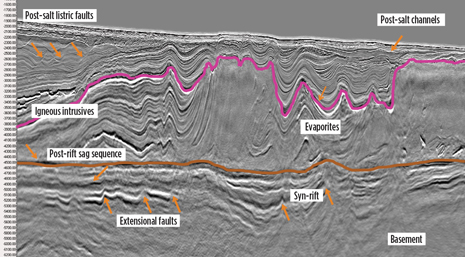 |
| Fig. 3. A regional seismic line of the fast-track processing results from the Phase 6-B broadband survey. Top and base evaporites have been interpreted, and arrows point to key features. |
|
The boundary between the upper syn-rift and post-rift sequence is marked by an erosional unconformity that represents a major change in depositional environment. This uncorformity indicates a change from an active rift environment to a period of thermal subsidence. During this phase, non-marine microbial carbonates were deposited, with build-ups forming above faulted basement highs. These post-rift sediments can be identified by uniform, parallel reflectors, along with aggredational build-ups. Recognition of this sequence is key to establishing potential reservoirs of non-marine carbonates, as observed in Lula field. All pre-salt reservoirs are sealed by a thick sequence of evaporates, that extend laterally across the basin. These evaporites consist of deformed halite, inter-bedded with autochthonous anhydrite and clastic sediments of Aptian age.
The post-salt sequence consists of intrusives, and clastic and carbonate sediments. Igneous intrusives are represented by high-amplitude reflectors. A strong black reflector indicates an increase in impedance, overlying a strong white reflector at the base, representing a decrease in impedance. Wing-like geometries are present, typical of intrusives, such as sills and dykes.
Extensional fault features, including small-scale listric faults, are identified, along with sediment slumps, where slumping occurs as a result of over-steepening. The increased bandwidth of the seismic data provides enhanced definition and texture to these features. A number of channels can be seen within the post-salt, with a clear differentiation in facies characteristics. Chaotic reflectivity is witnessed in the post-salt, indicative of deepwater turbidites. These represent the primary reservoir for the Oligocene-age Atlanta heavy oil discovery.
BROADBAND BENEFITS
A comparison of conventional and broadband data illustrates the improved definition of geological features and structures. An example of this can be seen in the dense faulting above a salt diaper, due to uplift and folding in Fig. 4. Enhanced imagery and better definition of fault planes are clearly visible on the broadband data. Smaller faults are highlighted, and fault splays distinguished, providing a more detailed, reliable interpretation of potential structures within the data.
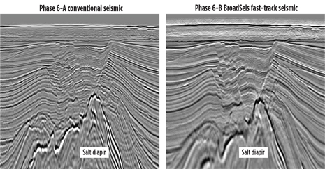 |
| Fig. 4. Conventional (left) vs. broadband fast-track (right) seismic highlights the improved fault structure seen within the post-salt. |
|
High-quality, low-frequency information gives a larger-scale envelope to the seismic signal that highlights the impedance variations caused by layering and facies variations. This gives more character to the reflection events and increases the confidence of correlating seismic interpretation across structural features.
Compared to other methods, broadband data suffers less from tuning effects, due to the broader bandwidth and sharper wavelet. This permits the interpreter to more easily identify fine detail and features, such as pinch-outs and thin beds, to better establish potential petroleum systems. Figure 5 shows how a simple petroleum fairway can be identified from the excellent detail within the seismic image, which clearly shows the presence of a reservoir and a seal. The top and base of channel sands, within a mud-rich depositional setting, can be identified by a strong black reflector, illustrating an increase in impedance, and a strong white reflector illustrating a decrease in impedance, respectively. Background low frequencies help highlight channel sand facies with subtle, darker colors in relation to adjacent mud-rich sediments. A depositional environment can be interpreted from the sandy facies of the channel structure encased within shale facies that are typically found within proximal channel systems.
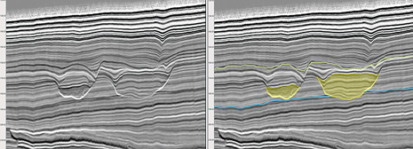 |
| Fig. 5. Phase 6-B fast-track broadband data showing post-salt channels. An interpretation (right) indicates the differentiation between facies using broadband seismic images. |
|
The Phase 6-B survey covers the post-salt Atlanta and Oliva discoveries, where structure and stratigraphy can be seen clearly. Within the post-salt Tertiary section, a clear oil-water contact can be interpreted, with an increase in impedance at the contact. This can be seen by cross-cutting of seismic reflectors by the contact shown in Fig. 6. Adjacent reflectivity displays a more chaotic facies, which is typical of turbidites. The increased resolution highlights minor, but potentially significant extensional faults, indicating potential compartmentalization of the reservoir.
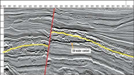 |
| Fig. 6. Phase 6-B fast-track broadband data, displaying the clear oil-water contact at the Atlanta discovery. |
|
Figure 7 displays seismic interpretation carried out at the top turbidite reservoir, and, from this, a direct amplitude extraction was made. The amplitude map displays the effects of increased resolution through the visualization of detailed fault systems. Interpretation shows a number of fault splays extending away from the main trending fault in a northeast-to-southwest orientation. Primary and secondary faults can also be observed, as well as a number of fault intersections. Using the amplitude map, hydrocarbon-filled sands are highlighted through bright amplitude anomalies (shown in yellow), which indicate two major accumulations and compartmentalisation of the reservoir sands into western and eastern structures, by large-scale fault systems.
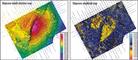 |
| Fig. 7. Depth structure map (left) interpreted at top reservoir and a direct amplitude extraction (right) from this interpretation. |
|
As seen in this Santos basin dataset, broadband data increase the precision and efficiency of seismic interpretation. In conclusion, broadband marine seismic can provide new opportunities and refinements to existing geological models, contributing to a better understanding of petroleum systems. 
ACKNOWLEDGEMENTS
The author thanks Steven Bowman and Roger Taylor for help with the article, and CGG Multi Client and New Ventures for permission to show the images from the Santos Phase-6B survey.
REFERENCES
1. Cainelli, C. and W. Mohriak, “Some remarks on the evolution of sedimentary basins along the eastern Brazilian continental margin,” Episodes, Vol. 22, No. 3, pp 206-216, 1999.
2. Soubaras, R. and R. Dowle, “Variable-depth streamer—a broadband marine solution,” First Break, Vol. 28, No. 12, pp 89-96, 2010.
3. Duval, G., “How broadband can unlock the remaining hydrocarbon potential of the North Sea,” First Break, Vol. 30, No. 12, pp 85-91, 2012.
4. Mann, J. and J. W. D. Rigg, “New geological insights into the Santos basin,” GEOExpro, Vol. 9, No. 1, pp 36-40, 2012.
|


