LI QIUGUO, XING ZHANG and KHALID AL-GHAMMARI, Schlumberger; and LABIB MOHSIN, FADI JIROUDI and AHMED AL RAWAHI; Oman Oil Expl. and Prod. LLC
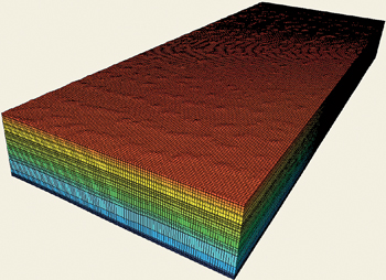 |
| A geological model of Abu Butabul field. |
|
Although 70 years are just a blip in geologic time, they represent the entire period that oil and gas companies have been modeling and simulating reservoirs. Of course, much has changed in terms of the technology available since the early 1940s, but the fundamental purpose has remained the same. Critical field investment and development decisions must be based on the best possible information, predictions and intelligence, gained from accurate, detailed modeling.
With the increasing requirement for hydrocarbon exploration and development in deepwater, unconventional and other challenging environments, accurate geomechanical modeling has become ever more critical for ensuring safe, cost-effective operations. Coming to the forefront over the last several years, it seeks to explain, and predict, changes to the mechanical rock state brought about by drilling, production or injection. These changes can be costly, considering that geomechanical issues are thought to be responsible for almost half of all drilling-related, non-productive time in high-pressure/high-temperature (HPHT), deepwater and other difficult environments.
These potential risks loom large, when it comes to drilling design. Subsurface stresses, wellbore stability, and pore pressures must be understood, and modeled, to establish safe mud weight boundaries in deep, complex wells. A modern mechanical earth model is a numerical representation of the geomechanical state of a reservoir, field or basin. In addition to property distribution and the fracture system, the model incorporates pore pressures, state of stress, and rock mechanical properties.
The ability to identify problems in the potential wellbore path relating to compaction and subsidence, well and completion integrity, cap-rock and fault-seal integrity, and fracture behavior, before they occur, is often the difference between financial success and failure.
These advantages can be illustrated with reference to geomechanical simulation undertaken for Abu Butabul field, Oman, in which a geomechanical modeling study was conducted to understand causes of wellbore instability problems, and provide recommendations for new well locations.
ABU BUTABUL FIELD
Discovered in 1998, the Abu Butabul gas-condensate field is onshore, within Block 60, in the western region of the central Omani desert, Fig. 1. The main reservoir is the Cambro-Ordovician clastic bank formation, buried 4,200 m below sea level, with very low porosity and permeability. Oman Oil had experienced instability problems while drilling appraisal wells in the field, especially in the shallower Natih, Nahr Umr and Gharif formations, and the deeper Safiq, Ghudun and Mabrouk formations, Fig. 2.
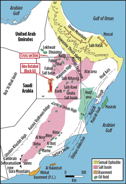 |
| Fig. 1. Abu Butabul field is located within onshore Oman Block 60 in the Western region of the Central Oman Desert. |
|
 |
| Fig. 2. Stratigraphy of Abu Butabul field. |
|
Abu Butabul is situated on a regional high, between the two early Cambrian salt basins that provided the principal source kitchens for northern Oman. The Barik sandstone comprises a prograding, braid delta plain and shoreface succession. The top seal is provided by marine mudstones of the Mabrouk member, and the base seal is formed by marine mudstones of the Al Bashair member. Internal seals are likely to be associated with intra-Barik marine flooding surfaces. The Barik sandstone is the principal reservoir interval that has been appraised in the structure.
Wellbore instability—caused by excessive stress concentrations at the borehole wall and inadequate mud support—had accounted for significant non-productive time while drilling appraisal wells. Oman Oil was keen to undertake 3D geomechanical analysis, to determine the appropriate mud weight to maintain stability for future well trajectories, prior to drilling. A 3D geomechanical model, once constructed, would provide essential geomechanical data for wellbore stability analysis, for any location. In addition, it would reduce the amount of time required for wellbore stability calculations and planning for new well locations.
GEOMECHANICAL STUDY
The objectives of the geomechanical modeling study were to characterize mechanical rock properties, pore pressures, and in-situ stresses, based on nine appraisal wells. The team also wanted to understand wellbore instability mechanisms and predict wellbore stability for future well trajectories.
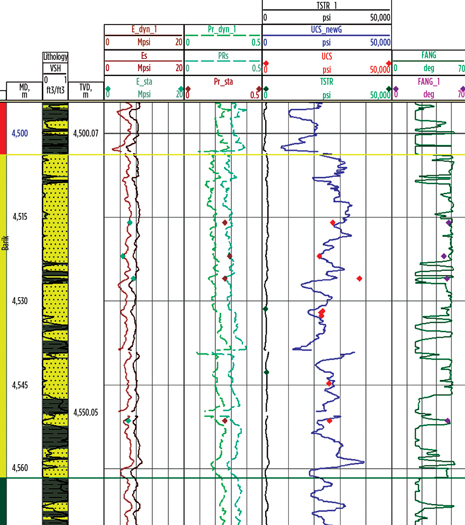 |
| Fig. 3. A comparison between log-derived elastic and strength properties, and those measured on core samples. |
|
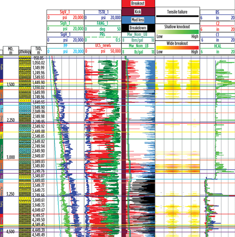 |
| Fig. 4. 1D MEM and wellbore stability analysis. |
|
To determine formation mechanical properties, pore pressures, in-situ stress orientation and magnitudes, 1D Mechanical Earth Models (MEMs) were constructed for the nine Abu Butabul appraisal wells. Each model described rock elastic and strength properties (Fig. 3), in-situ stresses and pore pressure as a function of depth, referenced to a stratigraphic column.1 The MEMs consisted of continuous profiles (Fig. 4) of the following rock mechanical data and parameters along the well trajectories:
- Mechanical stratigraphy, the differentiation of clay-supported rock from grain-supported rock
- Formation elastic properties, including dynamic and static Young’s modulus and Poisson’s ratio
- Rock strength parameters, including unconfined compressive strength (UCS), friction angle and tensile strength
- Pore pressures
- In-situ stress state, including the azimuth of the minimum horizontal stress, magnitudes of vertical stress, minimum and maximum horizontal stresses.
The team used wireline logs (compressional slowness, shear slowness, bulk density, etc.) to compute rock elastic and strength properties, and in-situ stresses. Rock mechanical testing data was available from six of the nine appraisal wells. Tests on core samples taken from the Mabrouk, Barik and Al Bashair formations included triaxial and unconfined compression, rock scratch, and Brazilian Tensile Strength. Static Young’s modulus was also measured on both vertical and horizontal core plugs. The values obtained were similar, suggesting that the rock samples were relatively isotropic. Correlations for calculating static Young’s modulus, static Poisson’s ratio, UCS, and friction angle were established, based on the rock mechanical testing data and wireline logs.
STRESS AND PRESSURE CALCULATIONS
Vertical stress at any point in the formation is equivalent to the weight of the formation materials above. The team integrated the bulk density log to calculate these values. Pore pressure was computed, using pressure gradients based on measured pore pressures, and the mud weight used for appraisal well drilling. Minimum horizontal stress azimuth was determined from borehole breakout observations, and drilling-induced fractures from the FMI borehole image and dual-caliper logs. It ranged from S20°E to S40°E across the field, which is consistent with the regional stress direction. Minimum and maximum horizontal stress magnitudes were determined, using the poro-elastic horizontal strain model.2 The minimum horizontal stress was calibrated, based on data from leak-off tests, extended leak-off tests, and closure pressures, interpreted from hydraulic fracturing pressures.
Since the magnitude of the maximum horizontal stress cannot be directly measured, it was inverted from analyzing fracture initiation pressures, and verified by conducting wellbore stability analysis and matching simulated shear and tensile failures with observed borehole breakout, and drilling-induced fractures.
The stress regime in the majority of the formations was found to be strike-slip, with the vertical stress being the intermediate principal stress. The mud weight window, and the agreement between the predicted borehole breakout and the borehole enlargement, indicated that wellbore instability problems during drilling were due to borehole failures, induced by inadequate mud weight. Borehole failures occurred mainly in the Natih, Nahr Umr and Gharif formations, and the bottom part of the Al Khalata, Safiq, Ghudun and Mabrouk formations. This was consistent with drilling observations.
INTEGRATING 3D SEISMIC INVERSION
A simultaneous inversion workflow was then applied to Abu Butabul field, to map out good porosity sand distribution, and obtain elastics property volumes for use in the 3D geomechanical model. Next, elastic rock properties, P-Impedance, S-Impedance, density and Vp/Vs, were determined from simultaneous inversion, by applying the full Zoeppritz equations to the angle of incidence range response in the seismic data.
Detailed petrophysical analysis and rock physics modeling were applied to correct any existing well log problems. The amended well logs were then calibrated with the seismic data, to ensure good sonic and density logs were tied to appropriate seismic events. Then, wavelets were extracted simultaneously from angle gather stacks at multi-well locations. After that, the low-frequency elastics property volumes for P-impedance, S-impedance and density were built, using horizons, stratigraphy information, and filtered log data. Finally, the simultaneous AVO inversion is run on angle gather stacks, with their respective wavelets, to generate P and S-impedance, and Vp/Vs property volumes, which were verified by comparison with the well logs.
With this information in place, the team could turn to constructing the 3D geomechanical model in three stages—model geometry construction, model properties definition, and initial stress modeling.
The geometry of the 3D model was based on an existing 1.7-million-cell, 17.2-by-46.7-km, geological model covering the surface down to the base of the Miqrat formation. Depth ranged from 4,453 m to 5,002 m, subsea level, with a water depth range of 54.1 m to 198.6 m. It included two bounding faults that intersect overburden and reservoir, as well as 26 other faults in the Barik reservoir.
The new model’s finite element mesh was constructed, based on the existing grid, with eight-noded brick elements. To reduce the impact of boundary constraints on simulated stresses in the 3D model, 20 additional rows of cells were added to each lateral direction, as well as an additional 25 layers underneath.
Material elastic and strength properties needed to be defined before initial stress modeling could be performed. The team used the Mohr-Coulomb constitutive model to simulate formation yield and plastic deformations, with properties taken from the 1D MEMs. Material properties were populated using a co-kriging algorithm. Acoustic impedance from a seismic inversion study was used to guide property distribution. Formation property variation between well locations was characterized, using the seismic information, as well as model-area well data.
Fault material properties were defined separately, based on the mechanical properties of the intact rock surrounding the faults and existing data sources. Properties include normal stiffness, shear stiffness, cohesion, and friction and dilation angles. Fault element material properties were also calculated, using both intact rock properties, and equivalent material properties methodology.3
Pore pressures in the 3D model were calculated, using pressure gradients estimated from the 1D MEMs. To simulate the initial in-situ stresses, horizontal stresses were applied to the model boundaries. Horizontal stress gradients were then determined from the horizontal stresses contained in the MEMs. Applied stresses, at the base of the model, were based on the gravity loading computed, using the density in all the elements.
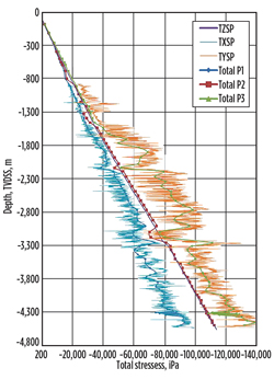 |
| Fig. 5. A comparison of stresses at the well location from 1D and 3D solutions. TZSP is vertical stress, TXSP is minimum horizontal stress, and TYSP is maximum horizontal stress from 1D MEM. Total P1 is minimum principal stress, Total P2 is intermediate principal stress, and Total P3 is maximum principal stress from the 3D geomechanical model. |
|
Initial stresses were then simulated, Fig. 5. The team validated the results by comparing principal stresses in the elements along the trajectories of the nine appraisal wells, with the stresses contained in the 1D MEMs. Agreement between the two solutions was achieved at all nine well locations, indicating that a representative stress state in the 3D geomechanical model had been established. The team also discovered that faults were having significant impact on the distribution of stresses—both magnitude and direction were altered in the vicinity of faults, Fig. 6.
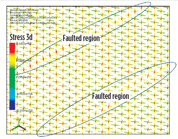 |
| Fig. 6. Stress magnitude and direction alteration in the faulted region. |
|
Since there was no production in the field at the time, the initial stress state was also the present day stress state, allowing the 3D geomechanical model to be used in wellbore stability analysis for additional appraisal and developmental well drilling.
WELLBORE STABILITY PREDICTION
After the 3D geomechanical model was constructed, it was used to predict wellbore stability for several planned developmental wells in Abu Butabul field. Rock mechanical properties, pore pressure, and stress tensor components for cells intersected by the planned well trajectory were extracted from the model. Mud weight windows, comprising pore pressure, fracture gradient (from minimum principal stress), borehole breakout and fracture initiation pressure gradients, were then calculated, based on extracted data for the planned well, Fig. 7. The team observed that formations predicted to require higher mud weight, to prevent borehole breakout, were similar to those seen in the appraisal wells—mainly Khuff, Gharif and Safiq. A mud weight of 1.3 to 1.35 g/cc was required to drill without significant borehole breakout. The fracture initiation pressure gradient was as low as 1.5 g/cc in the Al Khalata formation, meaning hydraulic fractures might be induced, if the Equivalent Circulating Density (ECD) exceeds that figure while drilling or tripping. However, since the fracture gradient was 1.65 g/cc, significant losses were not expected—even if hydraulic fractures could be induced near the wellbore.
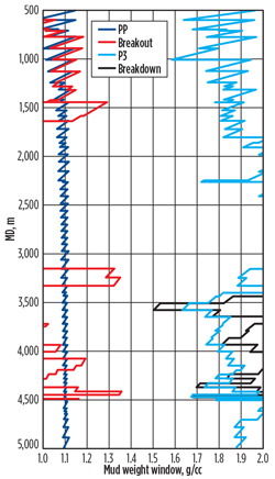 |
| Fig. 7. Predicted mud weight windows for a development well, based on the 3D geomechanical model. PP (blue) is pore pressure gradient; breakout (red) is the minimum mud weight required for preventing borehole breakout; P3 (light blue) is the fracture gradient and breakdown (black) is the maximum mud weight that can be applied before drilling-induced fractures are created on the borehole wall. |
|
With the designed mud weight following the mud weight windows, the subsequent developmental well drilling proved to be successful, in terms of wellbore stability. No significant borehole instability-related drilling problems were encountered.
Petrel geomechanics modeling software was used to build a 3D geomechanical model of Abu Butabul field, incorporating 1D MEM data, which revealed that the majority of the borehole enlargement and wellbore instability drilling problems in the appraisal wells were caused by shear formation failures, due to inadequate mud weights. The 3D geomechanical model constructed using 1D MEMs—the existing geological model and seismic inversion results—proved to be essential in characterizing the lateral variation of mechanical properties, providing better prediction throughout the full field.
Stresses simulated in the model, using the software’s finite element modeling tools, showed good agreement with the stresses shown in the 1D MEMs at the appraisal well locations, allowing the team to conclude that this was representative of the in-situ stresses in the field. The 3D model also revealed the extent to which faults effected stress state, clarifying that both stress magnitudes and stress direction were altered in the vicinity of faults.
Intelligence from the 3D model ultimately enabled the team to efficiently analyze wellbore stability for planned wells in Abu Butabul field. The resulting mud weight recommendations were used to reliably maintain borehole stability, and ensure drilling success. 
REFERENCES
1. Plumb, R. A., S. Edwards, G. Pidcock, and D. Lee, “The mechanical earth model concept and its application to high-risk well construction projects,” SPE paper 59128, presented at the IADC/SPE Drilling Conference, New Orleans, La., Feb. 23-25, 2000.
2. Fjaer E., R. M. Holt, P. Horsrud, A. M. Raaen and R. Risnes, Petroleum Related Rock Mechanics, 2nd Edition, Elsevier, 2008.
3. Zhang X., N. Koutsabeloulis, T. Kristiansen, K. Heffer, I. Main, J. Greenhough and A. M. Hussein, “Modelling of depletion-induced microseismic events by coupled reservoir simulation: Application to Valhall field, SPE
paper 143378, presented at the SPE EUROPEC/EAGE
Annual Conference and Exhibition, Vienna, Austria, May 23-26, 2011.
|
The author
LI QIUGUO is a principal geomechanics engineer at Schlumberger. He joined the company in 1998, after obtaining an MS degree in petroleum engineering.
DR. XING ZHANG is a geomechanics advisor at Schlumberger, with experience in leading, or advising on, more than 50 major geomechanics projects worldwide. Dr. Xing holds an engineering PhD from UST, Beijing, and a geoscience PhD from Imperial College, UK.
KHALID AL-GHAMMARI is recruiting and training manager for Schlumberger in the Middle East. He graduated from Sultan Qaboos University in Oman with a BS degree in geophysics.
LABIB MOHSIN holds a bachelor's degree in geophysics. He joined Schlumberger in 2003 as a wireline engineer. Since 2010, he has worked as petroleum engineering operation team lead in Oman Oil Exploration and Production.
AHMED AL RAWAHI joined OOCEP in 2010 as a geophysicist in Oman, responsible for seismic interpretation and reservoir characterization.
|
|


