ANATOLY NIKISHIN, Moscow State University; Contributors: NIKOLAY AMELIN, EVGENY PETROV and LASLO MILES, Geology without Limits, Russia; PER HELGE SEMB, ØYSTEIN LIE and NICOLAI DAHL, Petroleum Geo-Services
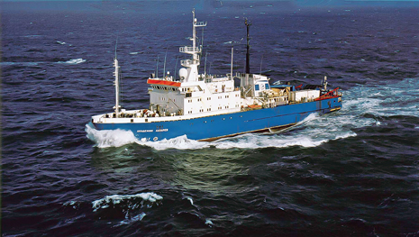 |
| The Akademik Lazarev was used to acquire 2D seismic data in the Barents and Kara Seas. |
|
In 2012, Petroleum Geo-Services (PGS), together with scientific consortium Geology without Limits, launched a long-term international scientific survey of the Barents and Kara Seas. The scope of work included increasing knowledge of the regional geology, tying the sedimentary basins, exploring interesting geological structures, and identifying potential well locations in the Barents and Kara Seas area.
SURVEY BACKGROUND
During the survey, 9,000 km of 2D seismic lines were acquired, primarily in the northern region of the Kara Sea and in the Barents Sea, Fig. 1. The new 2D network of seismic lines incorporates all major structural and tectonic elements of the Barents and Kara Seas, helping to clarify geologic structure of a vast region and aid in more precise hydrocarbon reserves assessment. Elongation of lines, into the Norwegian part of the Barents Sea, enables the construction of a comprehensive model of the Barents basin, based on well data in the Norwegian sector.
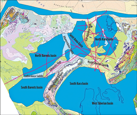 |
| Fig. 1. Location of the new set of seismic lines acquired through the Geology without Limits project. |
|
The scientific research conducted in 2012 showed that the northern part of the Kara Sea, usually marked out as the Kara plate, is a highly promising, proliferous region. Even at this early exploration stage, it is obvious that the area is quite encouraging, relative to other prospects on the Russian Arctic Shelf, and there are strong indications of oil dominance in hydrocarbon presence. Recoverable resources estimated by existing operators in the region have been significant in recent years. In this article, the authors discuss the geological features and indications of prospectivity observed within various basins, examined throughout the scientific research program. The first datasets from this scientific research program are now available through the PGS MultiClient team.
GEOLOGIC SETTING
The newly acquired network of seismic lines crosses major sedimentary basins of various ages: 1) North Kara basin (megabasin), with Ordovician rifts at its basement; 2) East Barents megabasin (with the South Barents, North Barents and Saint Anna basins), with Late Devonian–Mississippian rifts at its basement; 3) South Kara basin, with Permian-Triassic rifts at its basement; 4) passive continental margin of the Arctic (Nansen) basin. These basins are separated by major uplifts. The North Siberian Swell is located between the North Kara and South Kara basins. The Vize-Ushakov High is located between the North Kara basin and the Saint Anna basin. The southern boundaries of the Arctic Ocean’s passive margin are not yet distinctly determined in this region.
NORTH KARA BASIN
The North Kara basin was studied previously on the basis of 2D seismic lines acquired, mainly by Sevmorneftegaz (SMNG) (Dolgunov et al, 2011; Malyshev et al, 2012). In this basin, major depressions separated by rises were identified: Uedineniya Depression, Pre-Severnaya Zemlya Depression, Krasnoarmeyskiy Depression, and Urvantsev Depression. The data acquired in the most recent scientific program, on the whole, confirmed the previously made conclusions, and now we have obtained more detailed information on the structure of the individual features.
At the base of all of the depressions within the North Kara basin, rift structures are identified; however, their geometry is not recognized distinctly enough, Fig. 2. The bottom of the sedimentary cover is not always established unambiguously. Age of the rifting is considered to be Middle Ordovician (Drachev et al, 2010; Malyshev et al, 2012) by the probable analogy with the structure of the sedimentary cover of the Severnaya Zemlya islands. On the Severnaya Zemlya, Cambrian deposits are present, as well, in the form of a marine, rather thin shallow-water sedimentary cover. In this case, possible Cambrian formations may either form a pre-rift cover or enter into composition of the folded acoustic basement. Thickness of synrift sediments may reach 4–7 km (Nikishin, 2013). One of the tasks of the joint project is to refine the structure of the rift depressions at the basement of the North Kara basin.
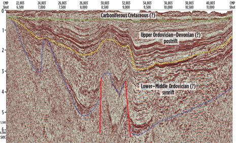 |
| Fig. 2. Interpretation of profile BK-014 fragment. An inverted Ordovician rifted basin can be recognized. The main compression deformation time was close to Devonian/Carboniferous transition. |
|
In the North Kara basin, there is a regional angular unconformity between Ordovician-Devonian and the overlying deposits, Fig. 2. The authors’ supposition is that this unconformity extends approximately at the level of the Devonian-Carboniferous boundary (Malyshev et al, 2012; Nikishin, 2013). This unconformity is easily seen on all seismic sections. A key question that remains is the age of the deposits occurring right above the unconformity: Carboniferous, Permian or Mesozoic. Carboniferous age of deposits right above the unconformity is believed to be most probable. In the North Kara basin, several inversion uplifts are singled out, with the main phase of growth approximately at the boundary of Devonian and Carboniferous. These inversion uplifts are probable structural traps for hydrocarbon deposits.
In the North Kara basin, salts and structures associated with salt tectonics were discovered (Dolgunov et al, 2011; Malyshev et al, 2012; Nikishin, 2013). It is believed that these salts are of Middle or Late Ordovician age, by analogy with salt-bearing deposits of the Severnaya Zemlya and the Timan-Pechora basin (Nikishin, 2013). Saliferous deposits were identified in the Urvantsev and Pre-Severnaya Zemlya Depressions. The data from this research program demonstrate a wider extension of salt deposits, Fig. 3. Salt structures have been discovered north of the Severnaya Zemlya islands and in the central part of the Uyedineniya Trough. These data show that the salt member may serve as the regional cap rock in the North Kara basin. However, thickness of the salt horizon or horizons is yet to be strictly assessed.
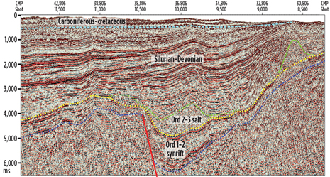 |
| Fig. 3. Interpretation of profile BK-013 fragment. A salt pillow can be recognized in the postrift deposits of the North Kara basin. |
|
Sediments of the North Kara basin experienced a compression phase at the boundary of Devonian and Carboniferous. These layers of the sedimentary basin were, at places, gently deformed and had formed, as was noted above, inversion structures. Carboniferous-Mesozoic deposits occur almost horizontally and have not experienced significant deformations. This means that the main phase of formation of anticlinal structures, as potential traps for existing hydrocarbons, was approximately the Devonian-Carboniferous boundary.
There are no wells in the North Kara basin. This basin’s section crops out on the islands of the Severnaya Zemlya Archipelago (October Revolution, Komsomolets, and Pioneer Isles). On these islands, the approximate thickness of the Ordovician-Devonian section is 4–5 km (Matukhin, Menner, 1999; Markovksy, Makariev, 1982). Ordovician is presented by alternation of siltstones, sandstones and carbonates, with horizons of volcanites and volcanoclastic rocks. Horizons with gypsum are known in Dapingian and Darriwillian stages of Middle Ordovician. Data on presence, or absence, of source deposits in the Ordovician section of the Severnaya Zemlya islands are unavailable as yet, though their presence in numerous layers of marks is quite plausible.
Silurian is presented almost entirely by carbonates: limestones, dolomites, marls. Silurian, at large, is composed of deposits of a shallow-water carbonate platform, with numerous carbonate edifices. Source deposits of Silurian are poorly studied as yet, but their presence was partly substantiated for Aeronian and Telychian ages of Lower Silurian.
Devonian formations are mainly presented by alternation of sandstone and siltstone layers, with individual horizons of carbonates. The main level of carbonates is confined to Pragian and Emsian stages of Lower Devonian (Matukhin, Menner, 1999). In the lower part of Emsian stage, there is a sequence of alternating gypsums and carbonates of the Rusanov formation. Devonian source rocks may exist in carbonate deposits of Pragian and Emsian stages.
Carboniferous and Permian formations overlie heterochronous formations of Paleozoic and Precambrian of the Severnaya Zemlya islands with an angular unconformity. They are preserved locally and are presented mainly by sandstone and siltstone rock masses, with thin coal horizons (Markovsky et al, 1999). These deposits are several hundred meters thick. Carboniferous and Permian deposits are continental and shallow-marine molasses. It is unlikely that they can play the role of a regional cap rock for the North Kara basin deposits.
This section of the North Kara basin is probably similar to the Ordovician-Devonian section of the Severnaya Zemlya islands, though thicknesses and facies may be significantly different. For example, the thickness of Ordovician deposits in the North Kara basin is expected to be more than 4–5 km. Thickness of salts might also be considerably thicker than on the islands. Silurian formations may be presented, both by a shallow-water carbonate platform and by deepwater depression deposits. Areas with different depositional paleodepths may be separated by belts with carbonate buildups. Devonian formations also may be presented by various facies. It is not yet clear whether or not Early Devonian salts are present within the North Kara basin, and if they are present, their areal extent. Carboniferous and Permian formations are probably present within the North Kara basin. But, their thickness is rather thin, and their areal extent is yet a matter of argument.
The upper part of the section of the North Kara basin is composed of Triassic, Jurassic and Cretaceous formations. They are probably mainly sandstones, siltstones and shales. The preliminary analysis shows that main reservoirs within the North Kara basin may be Devonian sandstones and Silurian carbonates.
EAST BARENTS MEGABASIN
The East Barents megabasin has been studied in more detail than the North Kara basin. Within it, several wells have been drilled, and well data are available on the Mesozoic section. The Shtokman, Ledovoye, Ludlovskoye, Kildinskoye and Murmanskoye hydrocarbon fields are known.
The East Barents megabasin consists of three major basins: the South Barents, North Barents and the Saint Anna (East Barents) basins. These basins are separated by the Ludlovsky and Albanov uplifts.
The structure of pre-Mesozoic deposits of the East Barents megabasin is almost unknown, because the existing wells have not penetrated deposits older than Permian. Late Devonian deposits of the Novaya Zemlya islands may be similar to coeval deposits of the East Barents megabasin.
Four megasequences (seismic complexes) of the East Barents megabasin can be singled out: 1) synrift megasequence (probably, Upper Devonian or Upper Devonian–Mississippian); 2) postrift, mainly carbonate, megasequence (Pennsylvanian–Middle Permian); 3) postrift clastic megasequence with clinoforms (Upper Permian–Triassic); 4) regional-platform sand-shale megasequence (Jurassic–Cretaceous), Fig. 4 (Nikishin et al, 1996; Drachev et al, 2010; Henriksen et al, 2011; Stoupakova et al, 2011).
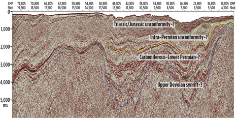 |
| Fig. 4. Interpretation of profile BK-008A fragment. Synrift and postrift deposits can be recognized. The basin was deformed close to the Triassic/Jurassic transition and later. |
|
In Pennsylvanian and Lower Permian deposits, evaporites may occur locally. On the flanks of the megabasin, small angular unconformities are observed between Triassic, Jurassic and Cretaceous deposits. Thickness of the sedimentary cover in the East Barents megabasin reaches 15 km or more.
Structure of the synrift complex is poorly studied as yet, and it occurs at deep depths. The main source rocks are considered to be deposits of Middle Triassic and top of Jurassic (Kimmeridgian-Tithonian). Source rocks are also possible in Upper Permian, Lower Triassic and Lower Cretaceous (Drachev et al, 2010; Henriksen et al, 2011).
The new data from this scientific research program show that the sedimentary cover of the East Barents megabasin was deformed with the formation of gentle anticlines in post Cretaceous time, at the boundary of Triassic and Jurassic, and in the middle of Permian. These are the phases of deformation, which are associated with the formation of main potential structural traps within the East Barents megabasin.
Within the East Barents megabasin, a large number of Cretaceous intrusions in the form of sills and dykes of various geometry is observed (Drachev et al, 2010), Fig. 5. Their number, especially in Triassic deposits, increases sharply toward the Franz Josef Islands. On these islands, numerous lava sheets and sills of Early Cretaceous age are present (about 123 Ma) (Corfu et al, 2013). This confirms that intrusions in the East Barents megabasin are of early Cretaceous to early Aptian age.
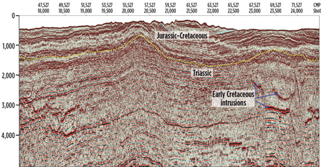 |
| Fig. 5. Interpretation of fragment of profile BK-007. Large anticline structure could be recognized in the East Barents megabasin. Time of deformation was after Cretaceous. |
|
SOUTH KARA BASIN
Thus far, the South Kara basin has been studied in relatively better detail than the North Kara basin (Drachev et al, 2010; Nikishin, 2013). The data from the most recent program are available for only its northern part. It is clearly seen that deposits of the Bazhenov formation (the main source horizon in the basin) are undoubtedly present, because a bright seismic boundary is seen distinctly at approximately the boundary of Jurassic and Cretaceous. Clinoforms in Early Cretaceous in Neocomian are also readily visible, with transport of clastic material from the north, from the area of the North Siberian Swell.
CONTINENTAL PASSIVE MARGIN
For the first time, the new seismic data show the structure of the passive margin of the Arctic Ocean for the Nansen Oceanic basin. This is a narrow passive margin, not wider than 100 km. Such narrow margins are often characteristic of wrench-fault (transform) boundaries. This means that there is a possibility that shear deformations along the present-time passive margin might have been in place at the early stage of opening the Eurasian Oceanic basin. This continental margin is probably composed of Eocene-Quaternary deposits. Graben complexes are, by all appearances, composed by Paleocene deposits. However, given the current state of knowledge in this area, it is difficult to evaluate the hydrocarbon potential of this sedimentary basin.
NEW PROSPECTS
In the Russian part of the Barents and Kara Seas, sedimentary basins of different ages are singled out. The North Kara basin is a post-rift sedimentary basin, with probable Early Ordovician rifting. The South Kara basin is also a post-rift basin, but with Permian-Triassic rifting. The East Barents megabasin is also a post-rift basin with Late Devonian–Mississippian rifting. The continental passive margin of the Arctic Ocean in the Kara Sea is of Cenozoic age. All of these basins have different hydrocarbon systems. The new seismic data reveal additional prospects and add significantly to the investigation of the hydrocarbon potential of the sedimentary basins of the Barents and Kara Seas. 
REFERENCES
1. Corfu, F., S. Polteau, J. Planke, H. Faleide, A. Svensen, N. Zayoncheck and N. Stolbov, “U–Pb geochronology of Cretaceous magmatism on Svalbard and Franz Josef Land, Barents Sea Large Igneous Province,” Geological Magazine, Vol. 150, Issue 06, November 2013, pp 1127–1135.
2. Dolgunov, K.A., V. N. Martirosyan, V. N. Vasilieva and B. G. Sapozhnikov, “Structural and tectonic peculiarities of structure and prospects of oil and gas potential of the northern part of Barents-Kara region,” Oil and Gas Geology, No. 6, pp 70–83, 2011 (in Russian).
3. Drachev, S. S., N. A. Malyshev and A. M. Nikishin, “Tectonic history and petroleum geology of the Russian Arctic shelves: An overview,” in B. A. Vining and S. C. Pickering, (eds.) Petroleum Geology from mature basins to new frontiers, proceedings of the 7th Petroleum Geology Conference, London, Geological Society, 2010, pp 591–619.
4. Henriksen E., A. E. Ryseth, G. B. Larssen, T. Heide, K. Rønning, K. Sollid and A. V. Stoupakova, “Tectonostratigraphy of the greater Barents Sea: Implications for petroleum systems,” in A. M. Spencer, A. F. Embry, D. L. Gautier, A. V. Stoupakova, K. Sørensen, (eds), Arctic Petroleum Geology, Geological Society, London, Memoirs, 35, 2011, pp 163–195.
5. Malyshev, N. A., V. A. Nikishin, A. M. Nikishin, V. V. Obmetko, V. N. Martirosyan, L. N. Klesсhina and Yu. V. Reydik, “A new model of geological structure and evolution of the North Kara sedimentary basin,” Earth Sciences, 445 (1), 2012, pp 791-795.
6. Markovsky V.A., P. G. Paderin, G. V. Shneyder, L. N. Lazareva, “Geological map of Russian Federation, Severnaya Zemlya Seria. Bolshevik Island,” T-47-VI, XI, XII; T-48-I, VII, VIII, IX, X., St. Peterburg, VSEGEI, 1999.
7. Markovsky, V. A. and A. A. Makar’ev, “Ordovician deposits on Severnaya Zemlya Archipelago,” in V. Ya. Kaban’kov and N. P. Lazarenko, (eds.),” Geology of the Severnaya Zemlya Archipelago,” Sevmorgeo, Ministry of Geology of the USSR, Leningrad, pp 22-29 (in Russian).
8. Matukhin, R. G. and V. V. Menner, 1999, The Silurian and Devonian stratigraphy of the Severnaya Zemlya Archipelago, Siberian Scientific Research Institute of Geology, Geophysics and Mineral Resources (SNIIGGIMS), Ministry of Natural Resources of the Russian Federation, Russian Academy of Sciences, Novosibirsk, pp 1-174, 1999, (in Russian).
9. Nikishin V. A., Intraplate and plate boundaries deformations of sedimentary basins of Kara Sea, PhD Thesis. Geological Faculty, Moscow State University, p 131, 2013.
10.Nikishin, A. M., P. A. Ziegler, R. A. Stephenson, S. Cloetingh, A. V. Furne, P. A. Fokin, A. V. Ershov, S. N. Bolotov, M. V. Korotaev, A. S. Alekseev, V. I. Gorbachev, E. V. Shipilov, A. Lankreijer, E. Yu. Bembinova and I. V. Shalimov, “Late Precambrian to Triassic history of the East European Craton: Dynamics of sedimentary basin evolution,” Tectonophysics, 268, pp. 23–63, 1996.
11.Stoupakova A. V., E. Henriksen, Yu. K. B zrlin, G. B. Larsen, J. K. Milne, T. A. Kiryukhina, P. O. Golynchik, S. I. Bordunov, M. P. Ogarkova and A. A. Suslova, “The geological evolution and hydrocarbon potential of the Barents and Kara shelves,” from A. M. Spencer, A. F. Embry, D. L. Gautier, A. V. Stoupakova and K. Sørensen, (eds) Arctic Petroleum Geology, Geological Society, London, Memoirs, 35, pp. 325-344, 2011.
|
The author
ANATOLY M. NIKISHIN is professor and head of department of Regional Geology and Earth History, Geological Faculty, Moscow State University. Dr. Nikishin graduated from Geological Faculty, Moscow State University with a BS degree in 1978, a PhD in 1982 and a Doctor of Science, 1992. His main geological interests are the geology of the Arctic and the sedimentary basins of Eurasia. |
|


