|
Covering the seven most prolific offshore basins in the world, Ion Geophysical’s BasinSPANS program has imaged a record-breaking 250,000 km in the 10 years since it was introduced, creating a roadmap of the deepest, coldest and most remote geologic formations in the world.
 |
Ion's ArticSpab shoot off Greenland marked the first time a seismic survey had been shot under ice.
|
|
Launched in early 2002 as GulfSPANS, Ion set out a decade ago to create a comprehensive data acquisition program of the Gulf of Mexico. At the time, a record 14 deepwater projects came online. In a 2002 Minerals Management Service (MMS) publication, the agency stated that oil and gas production from the deepwater Gulf had increased by 500% and 550%, respectively.
Burgeoning drilling and production activity has inspired newer geophysical surveys to learn more about these deep, hydrocarbon-rich basins: their structure, stratigraphy and rock properties.
The mega-regional seismic study provided a continental-scale view of the deep basins, as well as a cross-reference to the structure of onshore basins across five states, added several years later via a composite-strike and dip-lines grid. Currently, Ion has completed imaging over 41,000 mi in the Gulf of Mexico and recently reprocessed the entire original dataset using reverse time migration (RTM)—incorporating about 11,500 offshore wells in the velocity model building and interpretation stages. This has allowed operators to associate new discoveries and emerging plays with previous deepwater finds.
Since the launch of GulfSPAN (and subsequent North American studies in Nova Scotia, and the Marcellus and Niobrara shales), Ion has expanded the BASINS program to offshore East and West Africa, the Arctic (from Alaska’s Chukchi Sea to northeast Greenland), Asia Pacific, Europe and the Middle East, India and South America. Supported by research from geophysical experts and E&P companies worldwide, insights on properties such as deep target identification, source-to-reservoir migration pathways, source rock distribution and high-resolution definition of faults and salt sheets provide a comprehensive snapshot of entire petroleum systems. The BasinSPANS program is management by Ion’s GeoVentures group and the data is processed by the company’s GX Technology group.
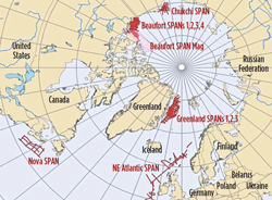
Ion’s ArcticSPAN program has seen several milestones of its own—including acquisition of the first long-offset, marine-towed streamer survey under ice. Having acquired over 60,000 km in Arctic regions since it began exploration work there in 2006, Ion recognized the need for a complete harsh-environment program. The company’s Marine Imaging Systems division created a five-point technology solution, Intelligent Acquisition, to acquire data from in-ice environments. In addition to the company’s solid-streamer acquisition system and towing technology to deflect ice from the streamers, Intelligent Acquisition also includes a polar-class icebreaking vessel, a central command technology to automate survey control, and dynamic positioning (DP) systems to maneuver cables around ice. So far, the ArcticSPAN libraries contain seismic data for the Beaufort and Chukchi Seas, and northeast Greenland. The successful data acquisition has added further understanding of these never-before imaged sub-ice basins, including establishing an increased operating window and a proven acquisition plan that expands previous exploration areas and improves the chances of a survey being completed.
As of 2012, Brazil has 14 billion bbl of proven oil reserves, a majority of which are located in the deepwater Campos and Santos basins. With the discovery of characteristic similarities between Brazil and West Africa’s petroleum systems, understanding the regions’ geology and tectonic architecture is more important than ever. Having acquired more than 50,000 km of 2D seismic data off Brazil’s coast, the BrasilSPAN program consists of three phases: Pre-Salt, Pelotas and Greater BrasilSPAN, the last of which was completed in 2012. The complete program includes imaging of the Campos, Santos, and Espirito Santos basins of central Brazil, the southern Santos and Pelotas basins, and the equatorial margins of Brazil from Espirito Santos to the Brazil-French Guiana border.
Data has shown an extension to the giant pre-salt Tupi field, and additional potential in the Campos and Santos regions. In cross-referencing Ion’s AfricaSPAN program, the datasets have identified patterns and similarities in the subsurface architecture and heat flows between the two once-joined continents. Further survey extension in the coming years will highlight more details about these joint properties and give operators a better roadmap on how to apply proven deepwater drilling and production technology to the vast resources offshore Africa. 
|


