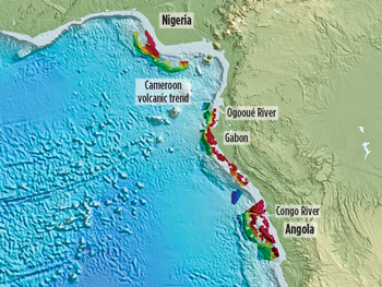
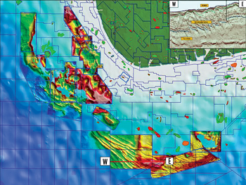
JENNIFER GREENHALGH, Petroleum Geo-ServicesThe west coast of Sub-Saharan Africa has been an area of focus for hydrocarbon exploration since the 1950s. World-class discoveries, such as Bonga field in Nigeria and Girassol field in Angola, illustrate the major petroleum systems operating within this region. The 2006 discovery of Brazil’s Tupi field and subsequent related presalt discoveries have further increased interest in the presalt analogs of Gabon and Angola. With increasing exploration investment in West Africa, there is greater demand for high-quality, detailed regional seismic data to assist in the exploration, understanding and derisking of these prolific hydrocarbon provinces. One such method, involving the use of very large migrated, merged 3D seismic data sets, is providing an unparalleled basis for understanding the regional geological development of the basins as well as allowing rapid screening for prospect and lead identification, and subsequent prospect derisking. This survey concept was initially pioneered in 1999 in the UK sector of the central North Sea, where it was demonstrated that 3D final processed SEG-Y volumes from multiple sources, of varying vintages, and with diverse acquisition and processing parameters could be merged. Originally, the data enhanced existing multiclient data by adding in neighboring surveys to extend the overall coverage. Additional surveys were obtained by individual brokerage agreements with oil company data owners; now it is mostly incorporated by means of government release regulations or exclusive agreements with national oil ministries. In West Africa, seismic data from three major national 3D merged-survey projects in Nigeria, Gabon and Angola were linked together using 2D seismic data from São Tomé e Príncipe and Gabon, and by outputting these to the same regional grid, Fig. 1. Additional surveys in the region are underway or planned. Interpretation of these merged surveys offers a fascinating view of the geology not only on a basinwide scale, but also down to a resolution capable of defining prospects or field extension opportunities.
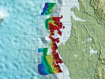
Regional setting. Both Angola’s and Gabon’s offshore areas are part of the Aptian salt basin of West Africa, which extends from the southern margin of the Niger delta in the north to the Walvis ridge in the south.1 This basin shares similar structural and stratigraphic characteristics with those of Brazil, on the opposing conjugate margin, due to their common origin during the Late Jurassic to Early Cretaceous rifting of the proto-Atlantic. The geological history of these basins is commonly divided by basin development stages, each characterized by particular petroleum systems. The syn-rift (presalt) stage is characterized by a series of asymmetrical horst and graben basins, within which thick sequences of continental (fluvial-lacustrine) sediments were deposited (narrow deep lakes, high clastic input, high algal bloom, plant detritus, anoxic bottom waters) leading to the formation of a world-class source rock. Reservoir rocks range from conglomerates and sandstones shed from horst blocks to lacustrine and fluviatile sandstones. As active rifting ceased, it was followed by the early post-rift, or sag, phase, which was characterized by the deposition of continental, fluvial and transgressive lagoonal rocks.2 The sag-phase sediments of the Brazilian conjugate margin are of significant interest at present, due to the 2006 discovery of Tupi field. The sag-phase sediments were overlain by an evaporite sequence, which accumulated as a result of repeated cycles of marine incursions across the Walvis ridge into a restricted basin and subsequent evaporation. Sedimentary deposition immediately postsalt was dominated by the initiation of halokinesis and the development of ramp- and shelf-carbonate facies, with minor clastic units deposited along the continental margin. As the basin areas developed and deepened, sedimentation became dominated by organic-rich shales and by clastic prograding systems, the distribution of which was controlled by the underlying salt structures. The earliest significant clastic input came from the development of the antecedent Congo River, which drained through the course in the valley now occupied by the present day Ogooué River.3 Substantial turbidite systems developed offshore northern Gabon, of which the best known and most prolific reservoir horizon is the Batanga sandstone. The southward migration of the Congo River to its present course had occurred by the Oligocene.3 This marked the cessation of significant deposition of turbidites in the Gabon offshore area, and the initiation of deposition of the Congo fan in the Lower Congo basin of the Angolan offshore area. The recent giant discoveries in the Angolan offshore area, Dalia and Girassol, produce hydrocarbons from sandstones of Oligocene to Miocene age, which are linked to the deposition of the Congo fan.4 The Niger Delta developed on the site of a rift triple junction, which related to the opening of the southern Atlantic.5 The delta sequence began to develop in the Eocene and built out across the Anambra basin until it extended onto the Late Cretaceous continental margin, building up sediments that are now over 6 mi (10 km) thick. Unlike the deformation caused by halokinesis in the post-rift section of Gabon and Angola, shale mobility caused internal deformation. Large shale diapirs formed as the poorly consolidated and over-pressured prodelta shales of the Akata formation were overlain by the higher-density delta-front sands of the Agbada formation. Later deposition of the Benin formation caused further deformation and created more complex structures. No Cretaceous sediments have yet been drilled under the Niger Delta due to the great depth of burial. Marine prodelta shales of the Akata formation form the primary source rock for hydrocarbons, and are overlain by the deltaic sands and shales of the Agbada formation. The majority of the hydrocarbons discovered to date have been in the Agbada formation sandstones, which are interbedded with shales acting both as potential additional source rocks and as intraformational seals. Merged-survey regional and prospect view. Based on more than 13,500 sq mi (35,000 sq km) of merged 3D seismic data, from more than 60 individual 3D surveys that were carried out over several years and in several phases, a comprehensive interpretation of the known hydrocarbon provinces of offshore Gabon has been carried out. This interpretation provides a regional geological perspective of the Gabon offshore area, including the ability to analyze and review different petroleum systems that may be operating in different parts of the offshore area. As discussed above, the major petroleum systems operating offshore Gabon are the post-rift Batanga turbidites in the north, with additional minor targets identified by operators. Upon further examination, these secondary, localized targets can be seen to have a significance that is more regional in extent. In 2000, an analysis was conducted of the Lower Miocene sedimentary fill of a significant submarine feature formed by the regional base Miocene unconformity, the Baliste-Crécerelle canyon.6 Two fields, Baudroie Marine (explored with 11 wellbores) and Baliste (explored with five wellbores), targeted and produced hydrocarbons from the canyon fill. Interpretation and analysis of the merged Gabon survey shows that additional submarine canyons formed by the base Miocene unconformity are present across Gabon’s northern offshore, but are as yet untargeted, Fig. 2.
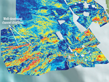
Another petroleum play that has been bypassed offshore northern Gabon due to the focus on the Batanga sandstones, but that shows potential for hydrocarbons, is the Eocene Ozouri formation, previously recognized as a minor target. The extraction of root-mean-square amplitudes from the data reveals the development of a significant channel system across the slope and into the deeper waters, Fig. 3. Further potential also exists offshore northern Gabon to develop the syn-rift presalt play that has proved to be so prolific in Brazil, as illustrated by the recent entry of Petrobras into two production-sharing contracts in the Mbeli and Ntsina blocks.
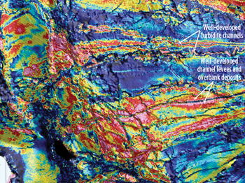
Further south, in the South Gabon basin, the presalt has always been the major target, due to a lack of post-rift turbidite targets. Exploration interest here continues to grow. A regional interpretation has been completed for over 25,000 sq mi (65,000 sq km) of merged 3D seismic data developed in stages over several years in the prolific hydrocarbon province of the Congo basin, resulting in a basinwide geological perspective of the Angola offshore area. The current focus is on the deepwater Congo fan area, where the exploration targets are post-rift turbidites of Oligocene to Miocene age. The sands are sourced from the Congo River, which has the world’s second largest drainage basin. The regional perspective allows an understanding of the deposition and distribution of turbidite systems in the area, Fig. 4. By using a series of horizon parallel amplitude extractions, it is possible to build up a detailed picture of the variation of channel distribution with time, and to demonstrate the controls on the hydrocarbon distribution in fields comprising deepwater fans and channels. Understanding the hydrocarbons in these discovered fields has enabled extrapolation into undrilled areas to identify potential prospective analogs.
Over 11,600 sq mi (30,000 sq km) of 3D seismic data offshore Nigeria has been merged, and this will soon be extended to about 19,300 sq mi (50,000 sq km), including coverage over Bonga field. The merged survey includes an interpretation with regionally consistent key horizons tied to released well data, which provides a framework understanding of the geology. The surveyed area extends from the extensional zone on the shelf through the compressional zone at the foot of the Niger Delta, an area dominated by blind thrust anticlines and imbricate thrusts, passing west and east onto the undeformed ocean floor.
The complexity of the structures from the ocean crust to the present-day delta top is impossible to comprehend from a purely block-sized data set, but the merged survey identifies a variety of different types of potential traps, Fig. 5. The data set contains many undrilled prospects, and these can by mapped across block and survey boundaries that would otherwise terminate the interpretation. This is particularly important in the case of channels that have a large extent. LITERATURE CITED
|
- Advancing offshore decarbonization through electrification of FPSOs (March 2024)
- Subsea technology- Corrosion monitoring: From failure to success (February 2024)
- Driving MPD adoption with performance-enhancing technologies (January 2024)
- Digital transformation: A breakthrough year for digitalization in the offshore sector (January 2024)
- Offshore technology: Platform design: Is the next generation of offshore platforms changing offshore energy? (December 2023)
- 2024: A policy crossroads for American offshore energy (December 2023)

