A flurry of experimentation advances the resolution and usefulness of increasingly complex azimuths in seismic acquisition.
Perry A. Fischer, Editor
The seismic industry is seeing the emergence of novel acquisition methods that use varying azimuths and offsets. These techniques are gaining mainstream acceptance as they prove their usefulness. These survey types improve illumination and can often improve signal-to-noise ratios by providing attenuation of some multiples. The main driver is the need to better image targets that are beneath complex overburden, especially subsalt targets. Also, it is still unpredictable whether/when a given target will be imaged differently depending on shooting direction. In general, the more shooting directions and the greater the data density, the clearer the image, provided you can afford it. But the law of diminishing returns applies.
The considerable added cost-two to four times as much as a conventional survey-will hold these techniques to a small portion of the seismic market. However, given the increasing depth of targets, in increasingly deep water, as well as $100 oil, and the need to avoid $100 million dry holes, the motive and money are there for market growth. This article gives a basic overview of the techniques, followed by issues and status of multi-directional acquisition.
BASIC DEFINITIONS
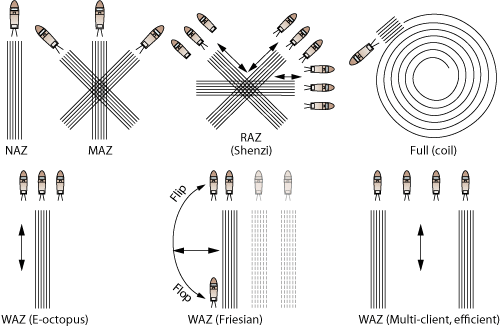
The definitions of WAZ, MAZ and RAZ have some overlap, especially given the variations that each one has and the way that they are evolving. Nevertheless, there is certainly a point where they are all markedly different. The basic geometries are illustrated in Fig. 1.
 |
|
Fig. 1. Various azimuth acquisition designs: conventional narrow azimuth (NAZ); multiple azimuth (MAZ); wide azimuth (WAZ); rich azimuth (RAZ) and the related coil (or spiral or full) azimuth. Names in parenthesis indicate where that geometry has been used.
|
|
Wide azimuth (WAZ) acquisition involves widening the effective receiver array, or offset, in the crossline direction. Previously it also applied to sail-line direction with conventional towed streamers, but that is now called narrow azimuth (NAZ) acquisition.1 WAZ acquisition is generally accomplished by a wide line of sources at right angles to the towed streamer direction, usually involving two to four source vessels. Typically, the lateral offset is increased with each pass along a source line. WAZ can be used for reconnaissance and multi-client data acquisition.
A multi-azimuth (MAZ) survey uses a conventional source/towed-streamer recording vessel. It focuses on a known target and crosses over it from as many as six different directions to acquire 3D data.
So-called rich azimuth (RAZ) is the least defined, being some combination of WAZ and MAZ. It is generally when a WAZ survey technique is applied in multiple directions over a target, as in MAZ. It is focused over a particular target and, with companies that are best able to exploit streamer-steering technology, includes shooting in the turn-arounds. A special case of this, which is still experimental, is to shoot in a coil or spiral.
ACQUISITION EXPERIENCE
Some of the survey designs shown have been used in acquisitions, primarily in the Gulf of Mexico, Fig. 1. The WAZ was used at Friesian prospect, a 2006 discovery in Green Canyon Block 599. The data was acquired with two flip-flop source vessels (front and aft), and three passes on the streamer vessel on each side, at 1,200, 2,400 and 3,600 m from the source vessel. Eight 9,000-m streamers were spread 1,200 m wide, which gave a 4,200-m crossline offset on both sides.2
The RAZ was done over Shenzi Field. It was acquired using three single-source vessels, with a source on the streamer vessel, in three azimuths, interleaving in two reciprocal directions with source vessels 1,200 m across on either side of the recording vessel. Data were recorded during turns for additional aperture. Ten 7,000-m streamers were deployed in a spread 1,200 m wide, providing 2,400 m of crossline offset in three different azimuths.2
WAZ was used for the E-Octopus Phase I multi-client survey. It was acquired with three single-source vessels running 1,200 and 2,400 m apart, including a source on the streamer vessel in two reciprocal directions. Ten 7,000-m streamers were spread 1,200 m wide, yielding a 3,200-m crossline offset on both sides.
A four-vessel WAZ survey was acquired with four single-source vessels 1,200, 2,400, and 3,600 m apart, including sources on two streamer vessels interleaving in two reciprocal directions. Ten 7,000-m streamers were used in a spread 1,200 m wide, yielding a 4,200-m crossline offset on both sides. It included two outer streamer vessels with sources interleaving in two reciprocal directions. Ten 7,000-m streamers were used in a spread 1,200 meters wide, yielding a 4,200-m crossline offset on both sides.2 This four-vessel design can acquire data almost twice as fast as a three-vessel design; it also provides better-quality data as a result of the larger crossline offset.3
The fifth survey design-in the shape of a coil-has been experimented with, but has not been applied commercially. It has the advantage of using a single vessel, with a rich azimuth spread, but a logistical disadvantage in the presence of strong wind/currents.
The need for source repeatability in the multiple passes of WAZ is similar to the problem in 4D acquisition; a primary goal is to achieve a repeat position of the center of source through multiple sail-line passes to achieve the required crossline sampling.4 Navigational software, steerable streamers, steerable sources and the methods used for 4D work are the ways that this issue can be managed.
The cost of these seismic methods depends on the number of vessels and passes. But it is the passes that achieve the desired quality. So the question becomes, “What is the optimum design?” That’s still being investigated, and to a large extent, it’s an interaction between the geology of the target, the survey objectives and the processing scheme. It should be noted that, in the case of an already expensive MAZ survey, adding more passes over the target achieves a very data rich area of near-offset traces, but the improvement in image is not likely to be much, since the area is already well sampled. In other words, it’s the law of diminishing returns.1
THE FUTURE: THERE’S WORK TO BE DONE
Some processed results were shown at the 2006 and 2007 SEG International Exposition and Annual Meeting. They clearly showed that these types of surveys provide an improvement in subsalt imaging. But several processing issues have yet to be worked out. The data probably will be reprocessed many times over in the coming years as methods improve.
Crossline source sampling is small in conventional inline surveys, which is one reason that WAZ surveys are done in the first place-to improve crossline sampling. Crossline sampling density can affect the subsurface illumination and the method used for multiple attenuation. The two obvious ways that crossline source sampling could be improved are 1) by decreasing the sail-line interval and 2) by adding more source arrays. But there are trade-offs.
Decreasing the source-line interval increases survey costs. Adding more source arrays could be more cost-effective if this could be done with dual-source arrays on each vessel, separated in the crossline direction with the desired source-line interval. However, with the sequential-source shooting technique, which is standard in the industry these days, the inline source sampling will be decreased.5
If two sources are fired simultaneously, the total number of traces will be doubled and the signal-to-noise ratio will increase. Although the simultaneous source shooting for marine acquisition was proposed in 1998 by Beasley and Chambers, so far it has not been used in production jobs.5
Although WAZ acquisition geometries attenuate multiples better than conventional narrow-azimuth surveys, new multiple-attenuation techniques are needed to get rid of residual multiple energy. For optimum performance of Surface-Related Multiple Elimination methods, sources are needed at all receiver locations, which of course is not practical. However, interpolation techniques can be used to fill in the necessary source data, but this becomes quite challenging for WAZ acquisition because of the sparseness of sources relative to the receivers.3
A recent SEG paper6 describes the use of a shot-based wave field modeling approach7 that lends itself naturally to a WAZ towed-streamer shot-record processing sequence. The two-step approach first generates a 3D multiple model followed by adaptive subtraction of a multiple model made from the recorded data. A composite, super-shot gather is obtained from the multiple sail-line gathers. The composite WAZ super-shot is formed after minor corrections for source positioning discrepancies between sail lines.
The nature of the WAZ super-shot gathers challenges current pre-processing practices, generally performed in the sail line or common offset volume domain, which would have to be applied to azimuth-sectored WAZ data in several passes. However, to realize the maximum benefit of the full 3D wave field recorded in wide azimuth datasets, Magesan et al. propose a one-pass, 3D shot-based processing sequence as an effective and flexible processing solution that will fully honor the 3D nature of the recorded wave field and properly take into account all the effects related to the complexity of the acquisition.6
CONCLUSION
Although most of the multi-directional acquisition experiments have been done in the Gulf of Mexico, it shouldn’t be long before the subsalt regions of Brazil and West Africa are also targeted. Difficulties with certain types of multiples remain, as do processing challenges for the various survey types. And high costs will be sure to keep these techniques for special projects for the foreseeable future. Nevertheless, image improvement can clearly be seen, and the fact that there are now at least seven WAZ multi-client surveys8 completed by, or being shot by, all of the major contractors shows the rate of uptake of this new technology. Already, wide-azimuth acquisition has gone from negligble in 2005 to a billion-dollar market today.9 
LITERATURE CITED
1 Howard, M., “Marine seismic surveys with enhanced azimuth coverage: Lessons in survey design and acquisition,” The Leading Edge, April 2007.
2 Kapoor, S. J. et al., “Subsalt imaging: The RAZ-WAZ experience,” The Leading Edge, November 2007.
3 Kapoor, S. J., “Techniques improve subsalt imaging,” The American Oil & Gas Reporter - November 2007.
4 Hite, D. A., Fontana, P. M., Slopey, B., I. Threadgold, “Optimizing source repeatability in wide azimuth surveys,” SEG Expanded Abstracts, International Exposition and 77th Annual Meeting, San Antonio, 2007.
5 Moldoveanu, N. and M. Egan, “Some aspects of survey design for wide-azimuth towed-streamer acquisition,” SEG Expanded Abstracts, International Exposition and 77th Annual Meeting, San Antonio, 2007.
6 M. Magesan et al., “Processing solutions for wide azimuth data: Outcome from a WATS field experiment in deepwater Gulf of Mexico,” SEG Expanded Abstracts, International Exposition and 77th Annual Meeting, San Antonio, 2007.
7 Pica, A. et al, “3D surface-related multiple modeling,” The Leading Edge, 24, 2005, pp. 292-296.
8 http://www.energy365og.com/SeismicShoots/seismic_shoots_01_08.pdf
9 Petroleum Geo-Services, Lehman Brothers CEO Energy/Power Conference, New York, September 6, 2007.
|

