A case history offshore Turkey in the Black Sea shows good results despite difficult geology and acquisition conditions.
Ed Palmer and John Bacon, WesternGeco; Ali Riza Toygar, Serdar Uygun and Cem Menlikli, Turkiye Petrolleri Anonim Ortakligi
To produce the rapid turnaround and accuracy demanded of deepwater exploration 3D marine surveys, acquisition teams need the most advanced tools available to collect and process a significant amount of data while in the field.
The following is the case history of a marine 3D reconnaissance survey that was conducted in deep water over a complex seabed and challenging target zone.
PROJECT BACKGROUND
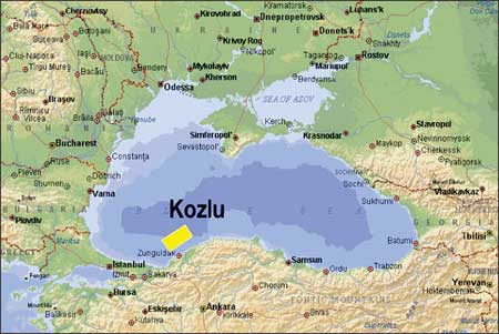
In 2006, the Turkish Petroleum Corporation (Turkiye Petrolleri Anonim Ortakligi, TPAO) contracted WesternGeco to collect and process data for the Kozlu exploration 3D seismic survey. Kozlu is located in the southwestern Turkish sector of the Black Sea, Fig. 1.
 |
|
Fig. 1. Location of the survey.
|
|
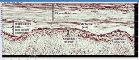
The Kozlu area seabed is quite rugose. Over the 2,850-sq-km survey area, water depths vary from 1,100 to 2,200 m, giving seabed reflection times of 1.5 to 3 sec. In this difficult marine environment, TPAO required high-fidelity images of a complex target that included limestone reefs and shales overlaying volcanic structures at depths of 3.5 to 4 km, Fig. 2. Also, in a number of areas, the seismic target was masked by strong water-bottom multiple energy. TPAO’s reservoir engineers also required a quick turnaround of initial results so that they could more confidently pick locations for exploration wells.
 |
|
Fig. 2. Kozlu structural setting.
|
|
The complexity of the target and sudden changes in water depth across the survey area presented a series of acquisition and processing challenges.
ACQUISITION CHALLENGES
Rip currents generated by the undulating seabed added further complexity by distorting the geometry of the eight-streamer, 6-km-long array that was towed behind the vessel. Steerable streamers, in conjunction with a dense acoustic positioning network, were used to control the streamer array in the presence of these currents, which were strong enough to increase streamer feather by over 15° within the space of 6 km. The streamer array remained parallel and under control nevertheless.
The seismic vessel Western Pride collected data from the end of September 2006 until early January 2007 using Q Marine single-sensor acquisition technology.
Over the course of the Kozlu survey, some 21 terabytes of field data were acquired from 700,000 shots and over 2 billion seismic traces.
DATA PROCESSING CHALLENGES
TPAO required high-fidelity data to assure reliable predictions of rock properties within the target zone. Achieving high resolution was difficult, in part because of the complex overburden which, in places, included layers of gas hydrates. Kozlu’s complex seabed and underlying geology created multiple reflections that often masked the target. There were no wells in the area that could be used to calibrate the seismic data. The recorded seismic data, while noisy, were usable after the application of adaptive noise-removal technology and swell-noise attenuation software, which was enabled by the unaliased 3.125-m single-sensor spatial sampling of the resultant noise.
The initial, intensive processing to remove surface-related multiples was done on the seismic vessel as the data were acquired. Throughout the survey, the acquisition team made full use of onboard data processing capability by applying an integrated seismic data processing workflow. Thanks to close cooperation and communication between the onboard geophysical team, the onshore processing center and TPAO geophysicists in Ankara and onboard the vessel, critical processing decisions were implemented without impacting the processing schedule.
A 2D Surface-Related Multiple Elimination (SMRE) technique required intensive computing resources. To pre-condition the data, traces were extrapolated to zero offset within the shot record, and the shot interval was reduced from 50 m to 12.5 m by 4:1 shot interpolation. This enabled the derivation of a multiple model which was adaptively subtracted from the input data set. This data set was then used as input to the fast-track migrated stack volume, and as input to a further intensive demultiple processing sequence applied to the main production data volume in the onshore data processing phase.
In some portions of the survey area, the relationship between water depth and seismic record length caused reverberations from one shot to overlap and contaminate the primary energy from the next shot. Although this unusual multiple energy would be attenuated in the high-fold common midpoint stack, it could also generate noise in the common-offset prestack migration, and hence, it would introduce noise on the low-fold Amplitude Variation with Offset (AVO) angle volumes. This issue was solved by applying noise attenuation on the common offsets.
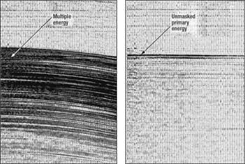
The geological and marine complexity of the Kozlu survey required the acquisition team to apply additional demultiple processing to the final high-resolution production 3D volumes. The extra steps included two passes of weighted least-squares Radon processing-one before and one after imaging the data-using isotropic Kirchhoff prestack time migration, plus the application of residual multiple attenuation techniques, Fig. 3.
 |
|
Fig. 3. Seismic record, with and without the multiple energy removed, using intensive, yet established, SRME methods.
|
|
ADVANCED MULTIPLE ATTENUATION
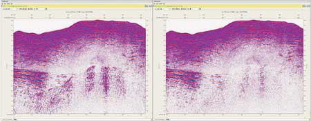
The intense effort to remove multiple reflections was successful to varying degrees across the entire Kozlu survey area. For more improvement, a more sophisticated demultiple algorithm was tested in one of the more challenging areas. The algorithm used was 3D General Surface Multiple Prediction (GSMP)-a new and novel application of 3D SRME technology. The algorithm produced a high-quality multiple model that accounted for the 3D effects of Kozlu’s complex, crossline-dipping seabed, plus the effect of streamer feathering caused by rip currents in some areas. A comparison is shown in Fig. 4.
 |
|
Fig. 4. Left, 2D “conventional” SRME solution; right, novel GSMP 3D solution.
|
|
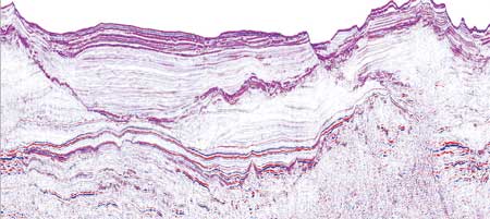
A sample from the final prestack data volume (Fig. 5) reveals the complexity of Kozlu’s geology. Additional angle stack volumes and reservoir property volumes, including fluid and lithology volumes, were also generated through inversion of the seismic data to aid interpretation in a complex exploration area. This additional data will help the placement of future exploration wells.
 |
|
Fig. 5. Kozlu final migration.
|
|
RESULTS
Isolated carbonate platforms are one of the most exciting exploration concepts developed by TPAO in the Black Sea in recent years. Developing and testing a carbonate play is always challenging, since reservoir parameters are highly controlled by diagenesis and, consequently, evolution of the carbonate system through time. Exploration in similar settings has clearly proven to the industry that each prospect might have different risks and reservoir quality might be drastically different within short distances depending on its individual history.
Our only means of ranking different prospects, pre-drill, with respect to reservoir risk is to work the hierarchy of reflection geometries and amplitude expression of key bounding surfaces and how these shift laterally and vertically through time as revealed by successive horizon slices in the data cube. For that purpose, we need high-quality, high-resolution seismic images of the subsurface.
Working with a seismic data set with a good image of clear clinoform geometries, raised-rims and low-stand build-ups, and with a good resolution to understand their spatial and temporal relationships, was critical at the end to lower the reservoir risk for the play substantially. Similarly, AVO fluid and lithology volumes derived from such high-resolution data were very critical in mapping charge-flags and evaluating sealing characteristics of certain seismic packages over prospects, so as to come up with a final story of the petroleum system.
CONCLUSION
The deepwater Black Sea is a challenging region for both collection and processing of high-quality seismic data, and requires leading-edge seismic solutions. Advanced data collection systems aid infield efficiency and data quality. The requirement for high-quality, fast-track products resulted in the very intensive processing of large data sets onboard the vessel, with associated high levels of computer power and communication.
The severe multiples seen in this deepwater environment required a combination of advanced and innovative demultiple solutions to produce the best-quality seismic image. 
|
THE AUTHORS
|
|
|
Ed Palmer earned an honors degree in physics and geophysics from Liverpool University. After graduation, he initially worked in Southern Africa in hydrology, diamond and mineral exploration. Later, he moved into seismic oil exploration with GSI Bedford UK, evolving into HGS, Western Geophysical and then WesternGeco-one company but many takeovers! His 25 years of experience in 2D, 3D and 4D marine data processing cover many projects with many oil companies around the globe. In 2004, he moved into Integrated Project Management with projects in Europe, Africa and the Black Sea. He is the geophysics manager for the Europe Region for WesternGeco.
|
|
| |
John Bacon works as an area geophysicist for WesternGeco and is based in the UK. Mr. Bacon has 28 years of seismic data processing experience, including the technical supervision of many seismic projects involving Q-Technology since 2001. Recent Q-Technology projects include those surveys recently acquired in the Black Sea. Mr. Bacon began a career in geophysics following graduation in 1979.
|
|
| |
Ali Riza Toygar is the Geophysical Operations manager for TPAO.
|
|
| |
Serdar Uygun is Data Processing manager for TPAO.
|
|
| |
Cem Menlikli is TPAO’s project manager for the Western Black Sea.
|
|
|


