NOVA SCOTIA CANADA: THE NEXT PLAY
Nova Scotia Offshore Regional
Geoscience Initiative
The government run Nova Scotia government Nova Scotia Regional Geoscience Initiative (NSORGI) is a comprehensive effort to understand the geoscience of the offshore regional area. A regional survey of long-offset, deep imaging seismic lines is exactly the type of data needed for underexplored basins like offshore Nova Scotia. The high-fidelity data, with its accurate, depth-based domain of the subsurface, can reduce cost and risk for explorers.
Houston-based GX Technology, with extensive experience in long-offset depth imaging of seismic data, has acquired depth-imaged long-effect data for offshore Nova Scotia.
GX Technology was able to gather data down to 20 km and image below salt canopies, which should give scientists a more vivid picture of the fundamental geology of the Scotian Slope Basin. GX refers to this data as its NovaSpan data set.
The company focused on imaging the entire petroleum system (or systems) and enabled integrated seismic interpretations from the shelf onto the abyssal plain. The NovaSpan data set also tied potential source rock intervals to potential reservoirs and traps, which allows researchers to key into deep wells for stratigraphic calibration in a region.
“A fundamental question that needs to be answered in understanding and realizing deepwater potential is deciphering what the NovaSpan data is telling us,” says Nova Scotia Energy’s Sandy MacMullin.

Specifically, the project will determine an accurate, depth-based domain of the subsurface. Because the program creates maximum resolution of geological problems like subsurface salt, salt or gas clouds and complex stratigraphy, at extreme depths, this data is key for offshore Nova Scotia.
The use of the GX Technology SPAN 2D survey concept, says Dr. Menno Dinkelman of Integrated Seismic Systems (ISS) for GXT, allows the oil and gas industry to save money on mapping and exploration costs while advancing the knowledge of geological information.
“SPAN surveys are of a basin reconnaissance nature with the objective to gain improved and new insights into the spatial and temporal relationships between basin framework and architecture and petroleum systems,” says Dr. Dinkelman.
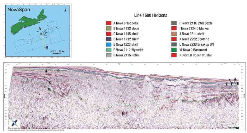 |
Regional 2D line about 150 km long from the NOVA SAN dataset.
Click image to enlarge.
|
|
“The use of SPAN data substantially reduces the very high risk associated with general regional basin knowledge, with substantial gains in improved structural knowledge. The better the information, the better become management decisions,” he says.
These current projects will add to the 40 years of geological expertise that has grown with the industry. Today, petroleum geophysicists and geologists involved in deepwater exploration continue to partner to realize the potential of offshore Nova Scotia. The NSORGI project involves the examination of the NovaSpan data set by local academic researchers and the presentation of results at technical forums.
The closely integrated research community has developed the capacity to discuss and advise in an informed manner. Geological findings related to the 204 wells drilled offshore Nova Scotia to date are not only being offered online free of charge, but are equally being studied and interpreted by Nova Scotia’s geological research community. 
|

