GEOLOGY
A new depositional model for the deepwater Wilcox-equivalent Whopper Sand - Changing the paradigm
Did the Gulf Of Mexico become isolated during the Lower Tertiary? If so, could that explain a series of events leading to the deposition of thick, extensive, mostly sandy reservoirs more than 200 mi from shore, which are now being explored?
Arthur E. Berman, Labryinth Consulting, Inc., Sugar Land; and Joshua H. Rosenfeld, YAX Balam, Inc., Granbury, Texas
The Lower Tertiary (Paleogene) of the offshore Gulf of Mexico has emerged as an important frontier oil and gas play with a series of major discoveries in the deepest parts of the Outer Continental Shelf (OCS) Alaminos Canyon, Keathley Canyon and Walker Ridge OCS protraction areas. Reservoirs comprise thin Eocene-to-Oligocene distal turbidite sands and a thick, sandy Paleocene-Eocene package called the “Whopper Sand.” The pre-Oligocene portion of this sequence correlates with the onshore Wilcox Group. The unique character of the Whopper is its generally high sand content (~70%) and great thickness (>1,000 ft), even though it was deposited hundreds of miles seaward of the Wilcox shelf margin and slope. The presence of such a reservoir so far from the shallow marine depositional centers of its contemporaneous basin challenges explorers to modify models derived from the onshore Wilcox as they seek to understand and delineate the new play fairway.
A Paleocene sea-level fall in the Gulf of Mexico by as much as several thousand feet was first proposed by Rosenfeld and Pindell.1 They suggested that tectonic closure of the Florida-Yucatan Straits isolated the Gulf of Mexico from the world ocean and resulted in a rapid evaporative drawdown. At that time, this hypothesis was used to explain the sandy reservoirs that had been encountered in the deepwater Perdido Fold Belt (Alaminos Canyon) region of the western Gulf of Mexico.
Over the intervening five years, at least 19 exploratory wells have penetrated the Whopper Sand across a 300-mi-wide swath of the deep GOM. Twelve of these wells have found oil and gas. Reserve estimates for deepwater Lower Tertiary reservoirs range from 3 to 15 billion boe, with first production scheduled for 2009-2010.
Interpretations that rely on an orderly, uninterrupted progression of shallow to deepwater facies from the Wilcox shelf margin to the Walker Ridge OCS protraction area have serious problems of scale. No other Tertiary depositional system delivered sand as far from the shelf margin as is required for the Wilcox, much less high net-to-gross sands over 1,000 ft thick, 225 mi from the base of the coeval continental slope.
Published industry interpretations consider the Whopper Sand to be a distal, submarine basin-floor fan deposit. These explanations would require gravity-driven, sand-dominated density flows to move across hundreds of miles of virtually flat basin floor. This is physically impossible. Defenders of the distal submarine paradigm claim that modern deepwater systems are capable of transporting sand onto the basin floor hundreds of miles from the base of the slope. This may true for thin, channelized sand bodies but not for thick, amalgamated sands covering thousands of square miles.
Modern sand channels that occur on the abyssal plain are typically underlain and surrounded by tremendous shale and silt volumes. In fact, turbidite systems require high clay content to prevent dropout of the suspended sand fraction near the base of the continental slope. The required shale volumes have not been found in conjunction with the Whopper.
We believe that the most reasonable explanation for the observed facies and thickness patterns in the basinal Wilcox strata is that a brief, though extreme, intra-Wilcox lowering of sealevel occurred in the Gulf of Mexico about 55 million years ago (Ma) at the Paleocene/Eocene boundary. This sea-level fall can only be explained by evaporation following tectonic closure and isolation of the Gulf of Mexico by the collision of Cuba with Florida. This caused rapid progradation of sand-rich deltas, fan deltas, and slope and basin floor fans, as the Gulf dropped about 6,000 ft below world sea level, Fig. 1. Sand reached the deep basin during this forced regression through the successive remobilization of previously deposited material.
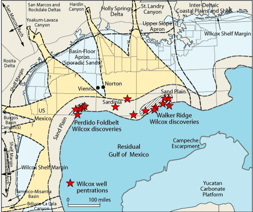 |
Fig. 1. Paleogeographic map of drawdown climax with Residual Gulf of Mexico occupying the otherwise desiccated abyssal plain of the Gulf. Modified from an unpublished figure by W. E. Galloway. Wilcox paleomargin (brown line) is overlaid.
|
|
The discovery of thick, amalgamated and widely distributed sandstone reservoirs in the Wilcox of the deepwater GOM represents an anomaly of great importance. The anomaly is without precedent in the depositional systems of the Gulf Coast basin and cannot be adequately understood using existing deepwater models, whether modern or ancient. Although difficult to visualize, there are several lines of evidence that support this explanation. To quote Conan Doyle’s Sherlock Holmes, “When you have eliminated all which is impossible, then whatever remains, however improbable, must be the truth.”
THE WHOPPER SAND
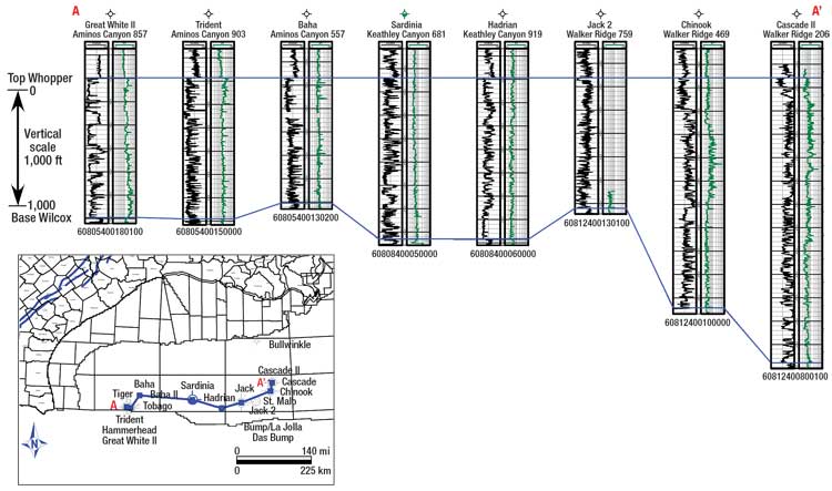
The gross thickness of the Whopper Sand, as determined from publicly available wells, ranges from 1,070 to 1,960 ft, Fig. 2. It represents a succession of sequences in the western part of the deep Gulf that are generally sandier, with more sharply defined bases and tops than in more easterly areas. The Wilcox interval in Alaminos Canyon comprises clean, amalgamated sandstone packages 25 to 100 ft thick that commonly have sharp bases and sharp to fining-upward tops. The underlying shales of the basal Wilcox and Midway are clearly identifiable from their log character.
 |
Click image for larger view
Fig. 2. Wilcox stratigraphic cross section showing key wells, Alaminos Canyon, Keathley Canyon and Walker Ridge OCS areas. Datum: Top Whopper (Wilcox). Data from IHS Energy. |
|
The following Whopper thickness estimates are based on the authors’ log picks. Alaminos Canyon penetrations include the Baha-2 well that drilled about 1,070 ft of this unit. The nearby Great White-II well found 1,200 ft of Whopper comprising 78% sand in blocky units about 180 ft thick separated by shaly or silty intervals from 10 to 90 ft thick. The Trident well had a very similar sandy section about 1,220 ft thick. Farther east in Keathley Canyon, the Whopper Sand has similar characteristics to the Alaminos Canyon wells, as found in the Sardinia-1 well with 1,180 ft of sand and the Hadrian well with 1,380 ft.
Continuing to the east into Walker Ridge, the Whopper is 1,120 ft thick in the Jack-2 well, 1,960 ft thick in the Chinook well and 1,940 ft thick in the Cascade-2 well. Walker Ridge wells generally contain more distal facies than wells in Alaminos and Keathley Canyon.
The considerable thickness and wide areal extent of the deepwater sandy Wilcox interval challenges the pre-existing perception that most Wilcox sandstone was deposited within shelf and upper continental slope environments with only thin, channelized sands reaching the deep basin within shale-dominated turbidites.
WILCOX ONSHORE STRATIGRAPHY
The onshore Wilcox Group was deposited in thick, predominantly shallow marine and coastal-plain successions during the first major episode of Cenozoic clastic sedimentary influx into the Gulf of Mexico basin. Lower Wilcox strata prograded over distal, fine-grained marine clastics of the underlying Midway Group. Thick, progradational shoreline and shelf-margin sequences characterize the Lower and Upper Wilcox intervals, while the middle Wilcox is a predominantly transgressive to slightly aggradational succession. The uppermost Wilcox is capped sub-regionally by thick, amalgamated, predominantly fluvial strata of the Carrizo Sandstone. It is separated from the overlying Reklaw formation of the Claiborne Group by a regionally extensive marine flooding surface.2
Wilcox sediment was shed from Laramide uplifts in the Rocky Mountains and Sierra Madre Oriental Range, and from the ancestral Appalachian Mountains. High sediment supply and limited accommodation space on the continental shelf caused Wilcox shorelines to prograde to the Paleocene shelf margin. The position of the Cretaceous platform margin beneath the Wilcox shoreline compounded the inherent instability of shelf-edge depositional processes. Underlying Cretaceous structure, which included a comparatively steep dipping carbonate slope, localized initial failure of prograding deltaic Wilcox deposits, resulting in slumps and down-slope sediment gravity flows into deeper water.
Loading by Wilcox sediments initiated or reactivated faulting in Cretaceous strata (Fig. 3) that was probably rooted in weak layers of mobile salt or shale at depth. Movement on deeper master faults produced shallower extension along growth faults within Wilcox sequences. Accommodation space on the slope was filled with a great volume of aggrading, relatively shallow-water sediments throughout Lower, Middle and Upper Wilcox deposition, Fig. 3. Younger Eocene Queen City and Yegua sediments prograded across the Wilcox slope basins and subsided into accommodation space on their respective slopes in basins above, and seaward of, the Wilcox depositional centers.
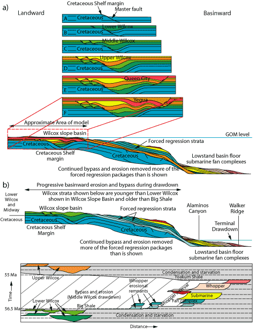 |
| Fig. 3. a) Simplified kinematic model for development of Wilcox slope basin. Model does not include salt withdrawal and is based solely on gravity-driven extension. Modified from Fiduk, et al.4 b) Wilcox diagrammatic cross-section at the time of Residual GOM drawdown. c) Wilcox time-stratigraphic (Wheeler) diagram. |
|
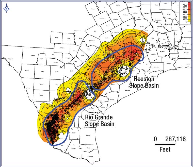
Wilcox deposition in the present onshore region was focused in two relatively discrete slope basins, Fig. 4. The Houston slope basin predominated during Lower Wilcox deposition in the Houston Embayment region of central and northeastern Texas. The depositional centers shifted southward to the region of the Rio Grande Embayment, where the Middle and Upper Wilcox accumulated in the Rio Grande slope basin. These slope basins had discrete seaward limits, because newly created extensional accommodation space was in apparent equilibrium with sediment supply. Despite the considerable volume of sediment delivered by the Wilcox system, seaward progradation beyond the eastern limits of Wilcox slope basins did not occur, except through bypass, until the initiation of Queen City and Yegua deposition, after the Wilcox basins had finally been filled and younger sediment prograded toward the deep basin, Fig. 5.
 |
Click image for larger view
Fig. 4. Houston and Rio Grande slope basins with Wilcox (undifferentiated) isopach map. Contour interval is 1,000 ft. Data from IHS Energy. |
|
|
Click image for larger view
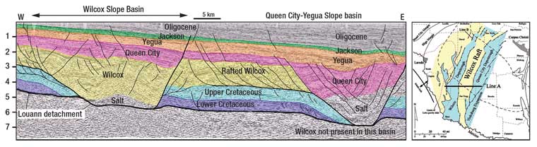
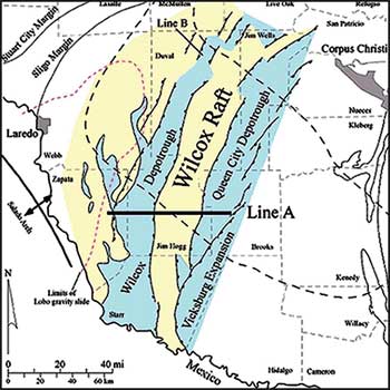
Fig. 5. (Top) Interpreted version of seismic profile Line A, highlighting Wilcox and Queen City-Yegua slope basins and rafted Wilcox in Zapata, Jim Hogg and Brooks counties, Texas. Modified from Fiduk, et al.4 (Bottom) Location map for seismic line, the Wilcox depositional trough and associated raft in South Texas. Yellow shading shows the general outline of Lower Cretaceous strata along the boundaries of the Wilcox depotrough and raft. Black dashes outline the area of the Rio Grande salt basin.4,5
|
|
Recognition of these areal constraints on the distribution of Wilcox strata has important implications when interpreting recently drilled wells in the deepwater GOM. Coastal, shallow marine, shelf-margin and prodeltaic Continental Slope facies were contained within Wilcox slope basins. The eastern limit of these basins did not reach the present GOM coastline, Fig. 1. Interpretations that show an orderly progression of shelf to deepwater facies, extending from the Wilcox shelf margin to the present-day Walker Ridge OCS protraction area, therefore, have serious problems of scale when compared to all other depositional systems in the GOM, and ignore geometric constraints gained from the drilling of thousands of wells and acquisition of considerable high-quality seismic data in the onshore Wilcox.
OFFSHORE WILCOX SEDIMENTARY SYSTEM
The deepwater offshore Wilcox Whopper Sand consists of a complex of channelized submarine fans and associated fan-lobe deposits similar to the Brushy Canyon system (Permian) of the Delaware basin, as described by Beauboeuf, et al.3 Log facies were interpreted using standard sequence stratigraphic methods to identify coarsening- and fining-upward vertical stacking patterns, and gross lithologies using normalized gamma ray and resistivity curves. Depositional environments include proximal channelized fan complex, medial channelized fan complex, distal channelized fan complex, prograding lobe, and marginal lobe facies, Fig. 6. There is an overall progression from more proximal channelized fan and associated lobe facies in western offshore regions to more distal facies in eastern areas across the Whopper Sand trend, Fig. 2.
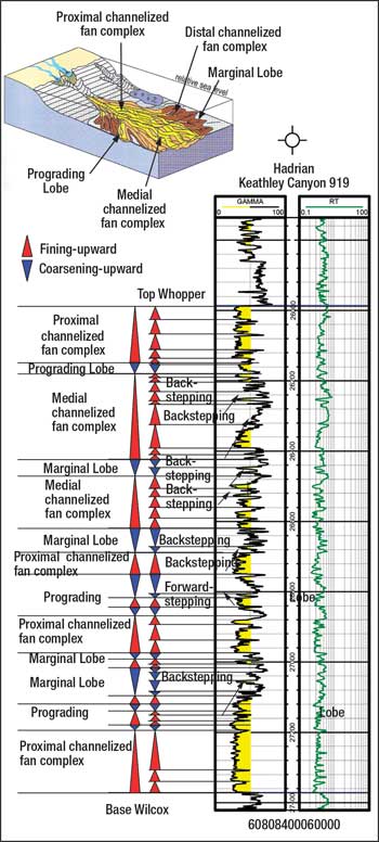 |
| Fig. 6. (Top) Depositional model used to identify submarine fan facies from well logs. Modified from Beauboeuf, et al.3 (Bottom) Facies interpretation of Whopper (Wilcox sand) in Hadrian well. Data from IHS Energy. |
|
Proximal channelized fan complex facies are typical of the Alaminos Canyon and Keathley Canyon areas of the GOM. This facies consists of clean, amalgamated sandstone packages 25 to 100 ft thick that commonly have sharp bases and sharp to fining-upward tops (Fig. 6, ~27,190-27,373 ft). Proximal channelized fan sandstones are commonly overlain by shaly overbank or abandonment facies that range from 10 to 75 ft thick.
Prograding lobe deposits appear lithologically similar to channelized fan facies, but differ because they coarsen upward and are eroded at the base of the overlying channelized fan facies (Fig. 6, ~27,120-27,192).
Medial channelized fan complexes represent an intermediate facies between proximal and distal channelized fan complex facies. These fan sandstones have sharp bases but, unlike proximal fan facies, individual sands clearly fine upward into finer-grained sandstone or siltstone (Fig. 6, ~26,180-26,420). These sandstone bodies are thinner than proximal fan deposits, ranging from 10 to 50 ft thick. This facies generally has a well-defined back-stepping vertical stacking pattern.
Prograding and marginal lobe deposits are associated with channelized fan facies. Both facies are composed of individual sand packages that generally coarsen upward. Marginal lobe deposits are distinguished from prograding lobes because they usually have a back-stepping stacking pattern, consist of thinner, sometimes laminated sand packages, and include a high percentage of intervening fine-grained overbank facies (Fig. 6, ~26,972-27,120). Like prograding lobes, marginal lobes are typically eroded at the base of the overlying channelized fan deposits.
Distal channelized fan-complex and marginal-lobe facies are commonly interbedded with one another and can only be distinguished clearly based on vertical stacking patterns. Distal channelized fan deposits contain thin, laminated sand bodies, such as marginal lobe intervals, and coarsen upward, while marginal lobes fine upward.
Walker Ridge wells generally contain more distal facies than wells in Alaminos and Keathley Canyon, but the Cascade and Chinook wells are sandier than the Jack and Jack-2 wells. The more distal facies recognized in Walker Ridge, compared with wells in the west, may reflect deposition in a less axial part of a fan, and does not preclude the presence of sandier, more proximal facies in other parts of the Walker Ridge area, possibly from a northern rather than a western source.
The considerable thickness and wide areal extent of the deepwater sandy Wilcox interval challenges the pre-existing perception that most Wilcox sandstone was deposited in shelf and upper continental slope environments with only thin, channelized sands reaching the deep basin within shale-dominated turbidites. The Whopper Sand, therefore, appears to be a channelized, proximal sandy submarine fan facies deposited below storm wave base in a drawn-down Gulf of Mexico.
The upper contact of the Whopper Sand with overlying shales is also abrupt, indicating that sand deposition ended suddenly across the whole area when the connection to the world ocean was re-established. The Wilcox lowstand systems tract was quickly flooded and preserved beneath the condensed section of the Middle Wilcox Group.
PALEOCANYON FEEDER SYSTEMS
The presence of Wilcox equivalent (Paleocene-Early Eocene) erosional paleocanyons has long been recognized from southern Louisiana to central Mexico. These have not been adequately incorporated into a regional understanding of the Wilcox Group, even though they provide significant supporting evidence for the sea-level drawdown hypothesis.
The Middle Wilcox Yoakum Canyon was eroded to a depth exceeding 3,500 ft across nearly 70 mi of the Lower Wilcox shelf. Several correlative canyons cut through shelves and slopes around the Gulf. In the US, these include the Bleakwood, Tyler (Hardin), Yoakum and St. Landry canyons; and in Mexico, the Bejuco-La Laja canyon and, farther to the south, the Chicontepec and Nautla Canyons (not shown), Fig. 1. These features have previously been interpreted as the result of normal submarine processes, such as headward slumping and scouring by sediment gravity flows. Some investigators specifically repudiate sea-level drawdown as the driving mechanism for the formation of these canyons. The sea-level drawdown, however, explains the canyons as fluvially eroded features that delivered bypassed sediment into the deep Gulf basin.
SUMMARY OF EVENTS
A series of connected events that better explains the Whopper Sand begins at the end of the Paleocene, as Cuba closed the gap between Yucatan and North America. The subducted oceanic plate dropped into the mantle, causing rapid uplift of the suture zone, enhancing the effectiveness of the barrier. Rapid evaporative drawdown of the Gulf of Mexico’s water level (1 to 3 ft per year) followed.
As evaporation proceeded, the shoreline of the Gulf advanced basinward at rates of 125 to 1,000 ft per year across the 1⁄2° to 1/10° slopes. This “forced regression” produced youthful river profiles with incision and cannibalization of stranded delta fans at the advancing canyon outlets.
The undercompacted Lower Wilcox/Midway substrate lent itself to accelerated downcutting and canyon wall mass wasting as relative pore pressure increased when the water column and sedimentary overburden was removed. Methane released from destabilized hydrates and eroded gas reservoirs also contributed to sediment slumping.
The drawdown ended with a residual body of water occupying the abyssal plain of the GOM. The coastal fringe of this residual Gulf consisted of a braided sand plain fed by coalesced alluvial fans. The nearshore shallows above wave base comprised a sandy shoreface. The coastal environment would have resembled a sandy glacial outwash plain. Landward of the shoreline, youthful valley profiles were progressively buried under a pediment of coalesced outwash.
Seasonal water level variations may have caused shoreline migration across the very low topographic gradient with wave reworking of the braided sand channels into beaches and sand bars. Turbidites were deposited in submarine fans below wave base.
Looking again at Fig. 3 provides a conceptual basis for the proposed depositional model. Lower Wilcox deposition was mainly confined to the slope basin seaward of the Cretaceous shelf margin, where growth faults provided accommodation space. Evaporation at the end of Lower Wilcox deposition rapidly lowered sea level, resulting in the forced regression of Wilcox strata across the Wilcox slope basin and exposed continental rise. These shoreface and deltaic fan deposits were cannibalized to become sand sources for proximal lowstand basin floor fans in the Residual Paleocene-Eocene Gulf. As drawdown progressed, proximal basin floor submarine fans continued to prograde at least as far as the Walker Ridge protraction area, where Whopper submarine facies include proximal, medial and distal channelized fan complexes, channel overbank and abandonment facies, and associated prograding and marginal fan lobe deposits.
Upon reconnection with the world ocean, the extreme lowstand system was quickly drowned and a condensed section (Yoakum Shale) was deposited across the basin and shelves until normal progradation resumed in the Upper Wilcox.
This interpretation explains the thick Whopper sand bodies in the deep GOM as the result of continuous cannibalization and redeposition of prograding alluvial and submarine fans during an extreme base-level drawdown. At any given time, the sand did not move a great distance across the low gradient slope but, in the aggregate, sand eventually accumulated hundreds of miles from its original source.
Incomplete cannibalization during rapid progradation left partially eroded fans beneath today’s shelf and slope which constitute important exploration targets. 
AWKNOWLEDGMENT
This article is excerpted from an upcoming issue of IHS’s Petroleum Frontiers, titled: “Deep Water Gulf of Mexico Wilcox Play: A New Paradigm for the Gulf Coast Paleogene,” Copyright 2007, IHS and its affiliated and subsidiary companies, all rights reserved.
LITERATURE CITED
1 Rosenfeld, J. H. and J. Pindell, “Early Paleogene isolation of the Gulf of Mexico from the world’s oceans: Implications for hydrocarbon exploration and eustasy,” in AAPG Memoir 79, The Circum-Gulf of Mexico and Caribbean: Hydrocarbon Habitats, Basin Formation, and Plate Tectonics, Bartolini, Buffler and Blickwede (Eds.), Chapter 4, 2003.
2 Xue, L., “Depositional cycles and evolution of the Paleogene Wilcox strata, Gulf of Mexico basin, Texas,” AAPG Bulletin, Vol. 81, No. 6, p. 937-953. June 1997.
3 Beauboeuf, R. T., et, al., “Deepwater sandstones, Brushy Canyon formation, West Texas,” Field guide for AAPG Hedberg field research conference, April 15-20, 1999.
4 Fiduk, J. C. and L. E. Anderson, M. G. Rowan, “The Wilcox raft: An example of extensional raft tectonics in South Texas, northwestern onshore Gulf of Mexico,” in, Post, P. J., Olson, D. L., Lyons, K. T., Palmes, S. L., Harrison, P. F. and Rosen, N. C., eds., “Salt-sediment interactions and hydrocarbon prospectivity: Concepts, applications, and case studies for the 21st century” 24th Annual GCSSEPM Foundation, Bob F. Perkins Research Conference, pp. 293-314, 2004.
5 Galloway W. E. and T. E. Ewing, C. M. Garret, N. Tyler, D. G. Bebout, “Atlas of major Texas oil reservoirs,” The University of Texas at Austin, Bureau of Economic Geology, p. 139, 1983.
ADDITIONAL BIBLIOGRAPHY
Galloway, W. E., et al., “Cenozoic,” in Salvador, A., ed., The Gulf of Mexico Basin,”Geol. Society. of America, p. 245-324, 1991.
Galloway, W. E., Ganey-Curry, P. E., Li, X. and R. T. Buffler, “Cenozoic depositional history of the Gulf of Mexico basin,” AAPG Bulletin, Vol. 84, No. 11, pp. 1743-1774, November 2000.
Posamentier, H. W., Allen, G. P., James, D. P. and M. Tesson, “Forced regressions in a sequence stratigraphic framework: Concepts, examples and exploration significance,” AAPG Bulletin, Vol. 76, No. 11, pp. 1687-1709, 1992..
|
THE AUTHORS
|
|
Arthur Berman is a geological consultant specializing in petroleum geology, seismic interpretation and database design and management. He has over 20 years’ experience working for major oil companies and was editor of the Houston Geological Society Bulletin. He earned an MS in geology from the Colorado School of Mines.
|
|
 |
Joshua Rosenfield earned his BA degree at the City College of New York in 1960, his MS degree at the University of Miami in 1978, and his PhD at the State University of New York - Binghamton, in 1981. His early career included geological reconnaissance, mineral exploration and mining geology in Central America followed by 19 years of petroleum exploration experience with Amoco plus 2 years with Veritas. Most of this time was spent studying areas in and around the Gulf of Mexico within the United States, Mexico, Guatemala and Belize. He is presently semi-retired in Granbury, Texas.
|
|
|


