Exploration Technology
Is Utah’s “Jurassic Wedge” a major petroleum province?
An integrated approach is needed for successful exploration in the Utah overthrust belt.
Rasoul Sorkhabi and Greg Nash, Energy & Geoscience Institute, University of Utah
The recent discovery and development of a new oil field in the central Utah fold-and-thrust belt has put Utah in the spotlight for renewed onshore exploration in the Rocky Mountain region of North America, Fig. 1. This would not have been surprising a few decades ago, but after major oil companies drastically reduced their ventures in the Rockies, the discovery, by the Wolverine Oil & Gas Corp., has amplified significance.
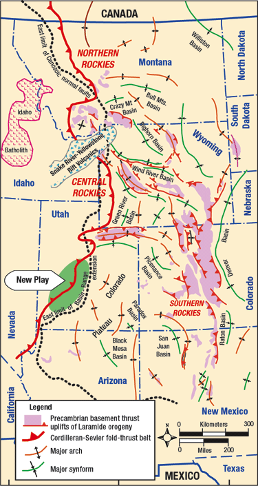 |
Fig. 1. The orogenic belt, basement uplifts, and major foreland basins formed from Late Jurassic to Eocene (modified after Hamilton, 1988).18
|
|
REGIONAL FRAMEWORK
Utah is divided into four physiographic regions: Central Rocky Mountains (northwest), Colorado Plateau (east), Basin and Range province (west) and the High Plateaus (Transition Zone) in central Utah. The Central Utah Fold-and-Thrust Belt is largely included in the Transition Zone, although it does extend westward, Fig. 2.
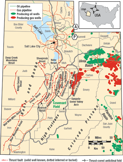 |
Fig. 2. Utah’s geological divisions include major thrust faults and arches (modified after Willis, 1999; Stokes, 1986),2, 19 including recently discovered Covenant field in Sevier County. The closest analogues are (A) Anshutz and (P) Pineview fields in NE Utah-SW Wyoming (data source: Willis, 1999, and Chidsey, 2003).20
|
|
The Transition Zone is structurally complex, having being affected by the compressional Sevier orogeny of Late Jurassic-Eocene, as well as Basin-and-Range extensional tectonics and volcanism of Oligocene-Neogene. Earlier, during Late Proterozoic to Devonian, the Utah overthurst belt was part of a long and prominent shelf margin, which separated a thick sedimentary basin in western Utah from a basin of relatively thin sedimentation in eastern Utah.
A series of thrust faults have been mapped or inferred in central Utah. These include, from west to east, the Canyon Range, Pavant, Paxton, Gunnison, and Wasatch thrusts. These faults generally dip westward, and become younger from west to east, as deformation migrated.1, 2
The thrust belt in southern and central Utah is part of the much larger Cordilleran orogenic belt that extends for over 6,000 km from Canada through the western US to Mexico. This belt formed as retroarc, fold-and-thrust mountains and foreland basins, as Pacific-side oceanic plates subducted under western North America.
The Cordilleran-Sevier foreland basins in Alberta, Canada, and in Wyoming, US, are proven petroleum provinces. The recent oil discovery in Utah demonstrates that the Utah overthrust belt is no longer the “orphan child” of the Rockies.4
OIL-RICH UTAH
The history of petroleum exploration and development in Utah dates to the 1890s. The majority of fields in Utah are concentrated in the Uinta and Paradox basins on the Colorado Plateau.
Prior to the discovery of Covenant field, 58 dry holes were drilled in central Utah. Previous ventures were unsuccessful because the wells were either too shallow, abandoned, or positioned using poorly-imaged, 2D seismic sections.
Wolverine’s discovery of Covenant field was highly publicized in professional journals,4, 5, 5, 7 international news agencies,8 as well as local newspapers,9, 10 as the biggest oil discovery in the Rockies since the 1975 discovery of Pineview field in northeast Utah-southwest Wyoming.
In 1981, Chevron drilled Salina Unit No. 1, a key well. It penetrated the Permian Kaibab limestone at 17,423 ft, and found oil shows in the Kaibab formation and Jurassic Navajo Sandstone. This drilling also facilitated the discovery of thrust-fold structure in the area, but with no commercial accumulation. Chevron pulled out of the Rockies in 1999, and then offered to sell its Utah leasing rights to Wolverine. Douglas Strickland, a Chevron geologist who did his post-graduate dissertation in western Utah, had an eye on the Utah overthrust belt for 25 yr. He persuaded Sid Jansma, Jr., Wolverine’s president, to buy Chevron’s acreage (including a 65,000 acre Federal Unit) and the 2D seismic section. The Wolverine team spent a year and half developing a play concept for central Utah. They offered their idea twice at the North American Prospect Expo and presented it to 65 potential industry partners, but no major company bought into it. Eventually, Wolverine sold the package to private investors and small companies.
Wolverine’s discovery well, 17-1 Kings Meadow Ranches, in Sevier County, Utah (SE NW 17-23s-1w), spudded December 9, 2003 and completed May 3, 2004. The well reached 10,750 ft TD in the Lower Jurassic Wingate Sandstone, penetrating the Twin Creek Limestone and Navajo Sandstone, Fig. 3.
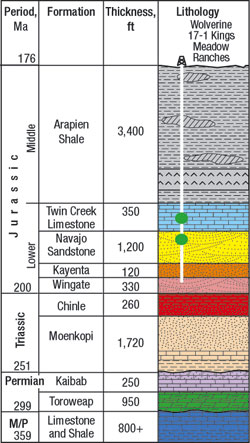 |
Fig. 3.. Covenant oil field stratigraphy (modified after Strickland et al., 2005 and Hintze, 1988).12, 21
|
|
Initial production was 708 bopd, which has increased to several thousand bopd with the drilling of nine development wells. These wells were directionally drilled from two surface locations, one at the discovery well, and the other, 17-2 Kings Meadow Ranches, about one half-mile south of the discovery. Wolverine spudded the second well on July 2, 2004 in SE SW 17, T23S, R1W.
Cumulative production for the discovery well was 391,429 bbl as of September 1, 2005. Currently, oil from Covenant field is moved by trucks, but with more field discoveries an oil pipeline and refinery are expected to be built. In 2005, Wolverine completed a 1,116-mi seismic survey in the Federal Unit. The company also drilled two wildcats in 2005 and 2006 on prospects north of Covenant field (both suspended) and is presently drilling a new well south of the field.
A number of small, independent oil companies are present in the central Utah overthrust belt, including Ansbro Petroleum Co. (Denver, CO), Armstrong Oil and Gas (Denver), Burnett Oil Co. (Dallas, TX), Clayton Williams Energy (Midland, TX), Cleary Petroleum Corp. (Oklahoma City, OK), Craig Settle (CO), Delta Petroleum Corp. (Denver), Granite Energy (TX), Hewett Energy (Salt Lake City, UT), International Petroleum LLC (Salt Lake City), Liberty Pioneer Energy (Salt Lake City), Lion Oil Co. (Denver), Paradise Energy (Ossining, NY), PetroHunt (Dallas), POGO Producing Co. (Houston, TX), Yates (Roseville, NM), Pioneer Oil & Gas (Salt Lake City), Samson Resources (Tulsa, OK), and Threshold Energy (TX). Some of these companies are conducting seismic surveys and planning to drill in the area. Ansbro and Cleary have already drilled one well each.
Land leasing prices in central Utah counties have jumped from about $10 an acre to over $1,000 an acre. The authors have even heard of leases at over $2,000 an acre. According to the Utah State Division of Oil, Gas and Mining, drilling permits for Sanpete and Sevier counties in central Utah increased from zero in 2002 to eight in 2005.
DUTTON’S “JURASSIC WEDGE”
Clarence Edward Dutton (1841 – 1912) of the US Geological Survey was the earliest geologist to map central Utah, documented in his Report on the Geology of the High Plateaus of Utah with Atlas (1879-1880).11 Dutton’s geologic map and cross section of the area show where the Covenant field was later discovered, Fig 4. Dutton observed:
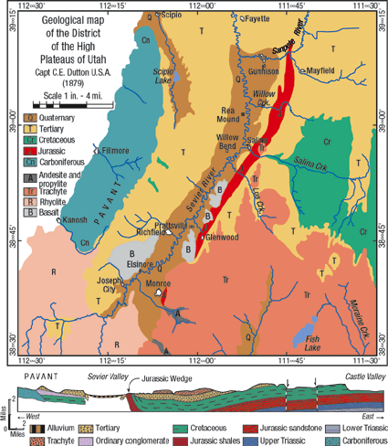 |
Fig. 4. C. E. Dutton’s geologic map and cross section of central Utah show the first mapping of the Arapien Shale and the “Jurassic Wedge” (red) (redrafted from Dutton, 1879-1880).11
|
|
“A remarkable displacement is found along the eastern side of the Sevier Valley, between Gunnison and Salina. A narrow belt of rocks of Jurassic age is thrust up, forming a chain of foot-hills and badlands, and the later Tertiaries are seen to flex upward against their western sides and terminate in a ‘hog-back,’ while they abut almost horizontally against their eastern sides. A small remnant of Tertiary beds is here and there found as a thin capping lying upon the Jurassic beds unconformably, and patches of volcanic rock farther southward are also seen to cover them. The belt of Jurassic rocks nowhere exceeds two miles and a half in width, but its length is nearly 40 miles, extending from a point about seven miles south of Manti along the base of the great monoclinal and the throw of the Sevier fault as far as Monroe, where it ends, to all appearances, somewhat abruptly, or perhaps disappears under the great mass of volcanic rocks which form the loftiest part of the Sevier Plateau. These older beds dip eastward, always at a high angle, which sometimes passes the vertical. This inclination was attained, without doubt, in part before the commencement of Tertiary time, probably during the Cretaceous epoch. It may belong to a class of flexures produced near the close of the Cretaceous, of which several instances are found in the district, chiefly in its southeastern portions. They all involve the Cretaceous beds in the displacement whenever they are present, but not the Tertiaries, which, when found in contact, overlie them unconformably. After the upturning of this flexure it may have stood as a long narrow ridge near the western shore line of the great Cretaceous-Eocene lake and been subject to a considerable amount of degradation, which removed the Cretaceous beds and finally planed down the whole mass until it stood but little above the common level.”
Dutton calls the 70-mi long, thrust-fold structure the “Jurassic Wedge,” which we use to designate the new play.
PETROLEUM SYSTEM
Geoscientists* involved in the discovery of Covenant field have reported information that helps characterize the petroleum system model for this new field.12 The following description and evaluation is based on data from these reports as well as those by Moulton and Pinnell4, 13 and Sprinkel and Chidsey.14
Source rock and oil geochemistry. The source rock was reported to be Mississippian sediments, based on biomarker signatures. In addition, total organic carbon over 2% was measured for a thickness of 1,000 ft with maximum values of over 15% for some Mississippian sediments.12 Outcrops of Mississippian formations in Utah include organic-rich gray limestone, marl and shale. Manning Canyon Shale, Chainman Shale, Doughnut formation, and the Delle Phosphatic member of the Desert Limestone are particularly organic-rich. These were deposited in marine conditions that prevailed over Utah, Fig. 5. Burial modeling indicates that source rock in western Utah reached thermal maturity for oil generation in Neocomian (130 Ma) followed by gas generation in Turonian (90 Ma), due to thrust loading.12
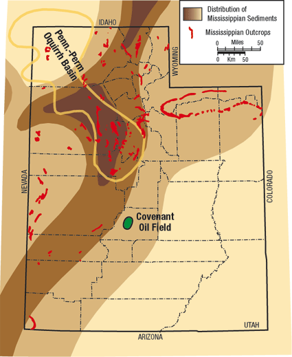 |
Fig. 5. This map shows the extent of Utah’s marine Mississippian sediments (darker = thicker), outcrops (red), and Oquirrh basin (yellow) (modified after Stokes, 1986).19
|
|
Geochemical analysis shows that Covenant field’s oil15 is high quality, 40°API gravity, dark brown in color, with low sulfur (0.48%), 474 ppm nitrogen, a viscosity of 4 cSt at 77°F and has a pour point of 2.2°F.
Reservoir. Reservoir rocks include the Navajo and overlying Twin Creek. The Lower Jurassic Navajo Sandstone is a desert, eolian, quartz-rich formation (Fig. 6), which has proven to be a major petroleum producer in Rocky Mountain foreland basins. It is called Nugget Sandstone in Wyoming and Aztec Sandstone in Nevada.
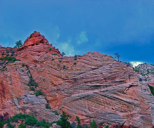 |
Fig. 6. Navajo eolian sandstone displays its cross-bedded structure in Zion National Park, Utah (photo by authors).
|
|
In Covenant field, the Navajo is about 1,200 ft thick; the upper 487 ft is gross pay with 424 ft of net pay. The average porosity is 12%, with 38% water saturation and permeability up to 100 md.12 It is not clear how much permeability is due to pore space versus tectonic fractures. But, a comparison with thrust-folded Navajo indicates that tectonic fracturing should play an important role. The reservoir is water driven, and formation water is fresh with 0.4 – 0.6 Wm on the electric log.
The Twin Creek is relatively thinner (350 ft), lays uncomformably over the Navajo, and has little matrix porosity, but is highly fractured. No outcrops of Navajo or Twin Creek are found in central Utah except for a strip of Navajo on the Pavant thrust footwall about 35 km west of Covenant field, Fig. 7.
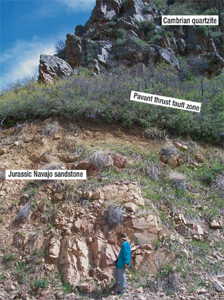 |
Fig. 7. The Pavant thrust near Fillmore places Cambrian quartzite atop folded and fractured Navajo Sandstone (photo by authors).
|
|
Cap rock. The 5,500 ft thick, Middle-Jurassic Arapien Shale forms the cap rock. This formation is largely calcareous shale associated with silt, halite, and gypsum. The high reflectivity of the Arapien blurs the Navajo on seismic images and complicates seismic interpretation.
The Arapien thickness in the undeformed subsurface is much less, probably a few hundred feet, but it has been thickened significantly by coupled processes of intraformational thrusting and salt diapirism.
Since the Arapien distribution is critical for oil reservoir integrity, we are using remote sensing to help define its areal extent and mineralogy. Presently, we use a combination of ASTER (Advanced Spaceborne Thermal Emission and Reflectance Radiometer) multispectral satellite imagery and high spatial resolution (1 m) digital orthophotos.
The fused images retain most of the spectral quality of the ASTER data, which facilitates rock type differentiation. The Arapien outcrops in central Utah in two major strips; one (47 km) along the west flank of San Pitch Mountains and the second (65 km) along the eastern margin of the southern-Sanpete and Sevier valleys. Fused imagery shows that Arapien outcrops east of mapped exposures in Sevier Valley, thus broadening the area where shale caps Lower Jurassic reservoirs.
Structural entrapment. The key trapping structure is a fault-bend-fold of the Gunnison thrust, which has developed into a duplex structure containing repeated Navajo reservoir horizons, Fig. 8. This duplex structure was found only after drilling. The well hit oil in the Jurassic reservoir (Navajo 1) at 5,840 ft instead of the expected 7,200 ft.12 The Gunnison thrust is thought to have developed from 80 – 60 Ma.1, 2, 3
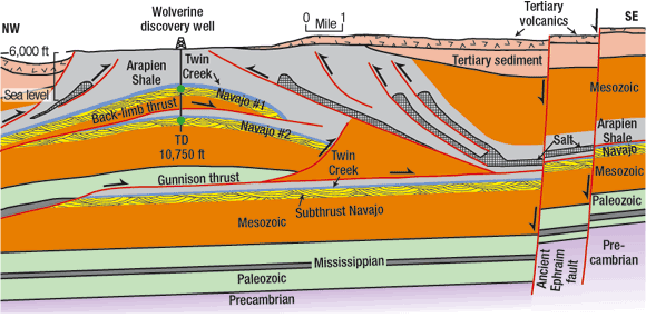 |
Fig. 8. A simplified cross-section of the Covenant oil field in central Utah (modified after Moulton and Pinnell, 2005; Strickland et al., 2005).4,12 Lower Jurassic reservoir units, Twin Creek Limestone and Navajo Sandstone #1 and #2, are located in a duplex structure of fault-bend-fold.
|
|
The Gunnison thrust is possibly detached at relatively ductile Mississippian sediments. A subthrust Navajo lies at deeper levels. The thrust fold developed to the west of the ancient Ephraim fault (mapped as a Jurassic extensional fault by Moulton, 1975).23 The whole fold-and-thrust structure has been superimposed by extensional structures of the Basin-and-Range province. This Cenozoic extension probably reactivated the Ephraim fault.
Migration pathways. Perhaps the least known parameter is the migration pathway from the Mississippian source rock to the Lower Jurassic reservoirs. The rock formations spanning this geologic time consist of 3,630 ft of sediments, including the sand-rich, Triassic Chinle and Moenkopi formations, and Permian Kaibab limestone.
If the burial history model12 is accurate, a 50-million-yr time gap between the onset of oil generation (130 Ma) and the development of the Gunnison thrust (80 – 60 Ma) implies that generated oil had time to migrate laterally and vertically through carrier beds or earlier faults at depth, and that post-Mississippian, pre-Middle Jurassic sediments contained oil before the development of the Gunnison structural trap.
It follows that Arapien acted as a regional seal for the Mississippian-Jurassic petroleum system for a long time before Gunnison thrust development. If this migration scenario holds true, Arapien distribution is a critical factor in locating prospects in Utah’s “Jurassic Wedge” – hence our interest in mapping the formation.
FUTURE PROSPECTS
Two questions remain. First, what is the reserve potential in the Utah overthurst belt? Doug Strickland considers the figure to be one billion barrels.5 Thomas Chidsey of the Utah Geological Survey is highly cautious of this figure,5, 9 while Floyd Moulton, another Utah petroleum geologist, considers the area to be “a super-giant.”16 The second question is whether there are other oil and gas systems and plays in the Utah overthrust belt, or is the Covenant petroleum system unique? We think that other plays and petroleum systems probably exist, although Covenant field provides an important proof-of-concept for future exploration.
Paleogeographic reconstructions show widespread distribution of Mississippian source rocks and Navajo reservoir rocks in Utah, much of which remain underground. However, structural complexity of the Utah overthrust belt, uncertainties in relationships between trap development, petroleum generation and migration, and uncertainties in 2D seismic interpretation make prospect analysis challenging.
An integrative approach encompassing a detailed understanding of the basin geology, proper identification of petroleum system elements, re-evaluation of data from previous drilling, and comparative analysis with similar fields in the Rocky Mountain foreland basins are critical for successful exploration.
The closest analogues for Covenant field are those in the Absaroka thrust sheet in southwestern Wyoming, which also extends into northeast Utah, especially Pineview (disc. 1975) and Anshutz (disc. 1983) fields. These produce from the Navajo (Nugget) Sandstone. 3D seismic surveys will also help to fine-tune prospects before drilling.
In the final analysis, success in Utah’s “Jurassic Wedge” is a testimony to Wallace Pratt’s exploration philosophy that “oil is [still] found in the minds of men.” And, if oil is reasonably thought to exist in a basin, failures should not discourage, but should rather be used creatively by the explorationist.17 
ACKNOWLEDGEMENTS
The authors thank Dr. Raymond Levey for his critical reading of this article, as well as Stephanie Bear and Erika Gleim for their drafting.
*Geoscientists involved in the discovery of the Covenant field include: Douglas Strickland, Keith Johnson and John Vrona of the Wolverine Gas and Oil Corp. and two consultants based in Salt Lake City, Dave Wavrek of Petroleum Systems International and Daniel Schelling of Structural Geology International.
LITERATURE CITED
1 Villien, A., and Kligfield, R. M., “Thrusting and synorogenic sedimentation in central Utah,” In AAPG Memoir 64, pp. 281-307, 1986.
2 Willis, G. C., “The Utah thrust system an overview,” In Utah Geological Association Publication 27, pp. 1 – 9, 1999.
3 DeCelles, P. G., “Late Jurassic to Eocene evolution of the Cordilleran thrust belt and foreland basin system, western U.S.A.,” American Journal of Science, vol. 304, pp. 105-168, 2004.
4 Moulton, F.C. and M. L. Pinnell, “Stunning Utah oil, gas discovery focuses spotlight on Hingeline,” Oil & Gas Journal, January 17, 2005a.
5 Brown, D., “Utah play makes lots of headlines,” The AAPG Explorer, April 2005.
6 Stefanic, V., “Utah discovery opens frontier,” The AAPG Explorer, April 2005.
7 Seal, M., “Wolverine gas and oil’s Covenant discovery,” Petroleum Technology Transfer Council (PTTC) Rocky Mountain Region (PTTC) Network News, 2nd Quarter 2005.
8 Foy, P. (Associated Press), “Small firm may have struck it rich in Sevier,” Desert Morning News (Salt Lake City), May 5, 2005.
9 Baumen, J., “Oil fields in Utah could be worth $5 billion,” Desert Morning News (Salt Lake City), June 17, 2005a.
10 Hales, J., “Oil discovery big but how big, and how will Sanpete be affected?” Sanpete Messenger, April 20, 2005.
11 Dutton, C. E., “Report on the Geology of the High Plateaus of Utah with Atlas. US Geographical and Geological Survey of the Rocky Mountain Region,” Department of Interior, Government Printing Office, Washington D.C., 307 pp. + 8 Atlas sheets, 1879-1880.
12 Strickland, D., K. R. Johnson, J. R. Vrona, J. R., D. Schelling, D., and D.A. Waverek, “Structural architecture, petroleum systems, and geologic implications for the Covenant field discovery, Sevier County, Utah,” AAPG Search and Discovery Article #110014, 2005.
13 Moulton, F. and M. L. Pinnell, “Central Utah: A new oil and gas province,” AAPG Search and Discovery Article #50020, 2005b.
14 Sprinkel, D. A. and T. C. Chidsey, “Exploration history and petroleum geology of the central Utah thrust belt,” AAPG Search and Discovery Article #10103, 2005.
15 Baseline DGSI, “Basic crude oil characteristics and biomarker analysis from the Kings Meadow Ranches No. 17-1 Well, Covenant Field, Sevier County, Utah.” Utah Geological Survey Open-File Report 467, 2005, 15 pp.
16 Baumen, J., “Geologist sees potential for giant oil fields in Utah,” Desert Morning News (Salt Lake City), December 13, 2005b.
17 Beaumont, E. A., and D. K. Strickland, “Creative Petroleum Exploration,” Course #8, 2006 AAPG Convention, Houston, 2006.
18 Hamilton, W. B., “Laramide crustal shortening,” In Geological Society of America Memoir 171, pp. 27-39, 1988.
19 Stokes, W. L., Geology of Utah, Utah Museum of Natural History and Utah Geological and Mineral Survey, Salt Lake City, 1986.
20 Chidsey, T. C., “Major oil plays in Utah and vicinity: Quarterly Technical Progress Report,” Utah Geological Survey, Salt Lake City, 18 p, 2003.
21 Hintze, L. F., Geologic History of Utah, Birgham Young University Geology Studies Special Publication 7, 1988.
22 Moulton, F. C., “Lower Mesozoic and Upper Paleozoic petroleum potential of the Hingeline area, central Utah,” In Symposium on Deep Drilling Frontiers of the Central Rocky Mountains, Rocky Mountain Association of Geologists, Denver, pp. 87-98, 1975.
[Note: A more comprehensive reference list may be obtained from Rasoul Sorkhabi at rsorkhabi@egi.utah.ed]
|
THE AUTHORS
|
 |
Rasoul Sorkhabi earned a PhD in geology (1991) and is a research professor at Energy & Geoscience Institute, University of Utah. He edited AAPG Memoir 85 (Faults, Fluid Flow and Petroleum Traps, 2005) and GSA Special Paper (Himalaya and Tibet: Mountain Roots to Mountain Tops, 1999). He has investigated structural controls on petroleum accumulation in various regions, including Wyoming and Utah. His work on fold-and-thrust belts has ranged from the Himalayas to toe-thrusts in deepwater basins.
|
|
 |
Greg Nash earned his PhD in geography (1996) at the University of Utah with specializations in geographic information science and geomorphology. He has focused on the application of remote sensing and geographic information systems for geothermal and mineral exploration in the Great Basin, including Utah, for the past two decades with occasional forays into petroleum exploration. He is a research associate professor in Civil Engineering, University of Utah.
|
|
|

