Seafloor Surveillance and Positioning Systems
The crowded seafloor: It’s getting easier to know precisely where you are
Multiple, simultaneous operations have reduced the time to first production, but positioning technology can suffer. Solutions have been emerging. This has significant implications in deepwater oilfield developments, where acoustic systems are increasingly essential.
Perry A. Fischer, Editor
Subsea projects are growing in number, importance and complexity. Taking into account all of the templates, tie-backs, towers, flowlines, pipelines, umbilicals, permanent and nodal seismic systems, and keeping it all properly spaced is an essential and difficult task – a task made even more difficult in deep and ultra-deep water. It is also time consuming and, therefore, expensive. Also, in some cases, all of this equipment must be accurately relocated. However, the past five years have seen systems evolve to meet these challenges.
Navigation and positioning applications are most often used for area surveys, and these have been continually improving, especially due to the increased autonomy and use of various Autonomous Underwater Vehicles (AUVs). Other uses include route surveys for planning pipelines, flowlines and tie-backs, as well as periodic inspection of these; and high-precision positioning needs, brought about by new technologies in well intervention, seismic acquisition and seafloor infrastructure.
Thanks to miniaturization and advances in microchip technology, some of the ideas of GPS can be applied to subsea positioning tasks. Although the seafloor is not able to directly use the GPS satellite system, the seafloor must nevertheless be GPS referenced, via sea-surface-based GPS receivers. Sonar provides the link between the surface and the seafloor. Typically, geometric triangulation from baseline stations provides for the precise position seafloor position. These baseline stations can be on the seabed, water surface, or ROV or diver carried.
SYSTEM OVERVIEW
Over the years, calibration time is decreasing and accuracy is increasing for most systems.
The basic geometries of some well-established systems follow.
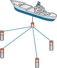
Long baseline (LBL – Fig. 1) systems secure three or more baseline transponder beacons moored in fixed locations on the seabed near the “corners” of the targeted area, tracking the position of a subsurface ROV, AUV, ROV or similar device relative to those stations with a high degree of accuracy over a large area, even in deep water. There is also good observational redundancy with four or more transponders. Baselines of 400 ft to more than 4 mi are possible. Only one small transducer is required per reference/ pole deployment.
These are not simple systems, and require experienced operators. Neither are they cheap, in part because of the time consumed for deployment and recovery. Some systems require comprehensive calibration at each deployment, especially for deepwater seafloor-based systems. In addition, LBL array deployments have to be well-planned in areas that have significant variations in seabed topography, in order not to lose line-of-sight.
 |
|
|
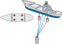
Short baseline (SBL – Fig. 2) systems use four or more sonar antennas mounted on surface vessels, yielding a reference baseline of about 15 to 50 m. Positioning is tracked relative to the vessel. The system is low in cost and simple to operate with everything being shipboard. Receiver/ transducer gate valves are small, and there is moderate spatial redundancy built in. Accuracy is good, especially with time-of-flight systems, but as water depth increases, larger baselines are required. Very good calibration to vessel structure is required. If absolute position accuracy is required – as opposed to relative position – it requires additional sensors, such as the ship’s gyro and Vertical Reference Unit. This system is well suited for most ROV piloting. If the position of the vessel is to be referenced to some fixed or inertial frame such as one fixed to the seabed, as is the case for DP vessels, then at least one beacon should be placed on the seabed and used as a reference point.
 |
|
|
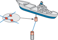
Ultra short baseline (USBL – Fig. 3, also called super short baseline) has a baseline of about 10 cm. Positioning is tracked relative to a vessel but, in this method, a single transceiver is used as a reference point, typically in a pole mounted to the side of the boat. It has the advantage of being simple to deploy and commensurately low in cost. It also has good ranging accuracy with time-of-flight systems. The trade-off is that it requires detailed calibration, which might not always be rigorous, including the alignment of the transceiver/ transducer gate valve. Overall, the method tends to be less accurate than other methods.
 |
|
|
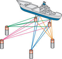
The above systems may be combined (Fig. 4) in myriad ways when conditions dictate varying types of accuracy for different operations. Some of these combinations are: long and ultrashort baseline (L&USBL); long and short baseline (L&SBL); short and ultrashort baseline (S&USBL); long, short, ultrashort baseline (L&S&USBL). The advantages, disadvantages and costs are also combined. These can be quite difficult to price and logistically operate, but may nevertheless be worthwhile, especially when there are several activities to consider.
SIMULTANEOUS OPERATIONS/ ACOUSTIC POLLUTION
Simultaneous activity has been a boon to the industry, shaving as much as five years off of the time between discovery and first oil. It can be complicated by nearby work for extending fields and work for enhancing recovery, since subsea positioning requires sonar. The result is a kind of acoustic pollution. Multi-user systems allow various vessels to use the same transponders even when working in close proximity. It is now common to have several activities at the same location, such as a drilling vessel, construction barge, pipelay barge, ROV and AUV support vessels. All of these vessels and activities create a cacophony of noise in addition to multiple transponder queries.
In the past five years, solutions for multiple users have been evolving to allow increased simultaneous activity. Wideband, spread spectrum, advanced signal processing and more channels within the same frequency band allow seafloor beacons and surface transponders to communicate with different vessels doing different work simultaneously. Areas such as West Africa, Brazil and the North Sea are some of the areas that sometimes experience acoustic pollution.
NEW SOLUTIONS
Two new offerings are helping to address the needs of multi-use systems.
Wideband. Any attempt to implement a system that emulated GPS underwater would be technically and commercially compromised by the differences between atmosphere and ocean, as well as the expense and complexity of the measurement solution. However, GPS uses wideband signals that can offer significant advantages in USBL and LBL systems. Recent advances in high-speed digital computer technology and the increasing application of digital signal processing in mass applications, such as mobile telephony, have driven the development of small, low-power consumption Digital Signal Processors (DSP). Systems like Sonardyne’s Fusion, with low-power DSP, offer a low-risk route to a step-change in performance through the support of wideband signals, while still recognizing traditional analog burst signals. This equipment has been extensively operated over the last two years in an extreme range of environments from the icy waters of the Grand Banks to the straits of Singapore and the immense pressures of deepwater West Africa and the Gulf of Mexico.
Tone burst vs. wideband. The majority of acoustic positioning systems used for subsea work over the last 30 years use analog electrical circuits and simple pulsed, narrowband continuous wave signals. These tone-burst systems are fundamentally limited in terms of the number of unique operating channels. They are also subject to fade and lack resolution in noisy, reverberant environments, where multiple signals may arrive at a receiver within a short time interval. In a tone-burst system, optimal ranging precision requires very high frequencies and short pulses that are subject to greater attenuation, lack power and, therefore, have a limited operating range. The simplicity of the signal architecture limits range resolution, since this is determined by transmission bandwidth. This means range resolution is effectively noise-limited, because the signals lack bandwidth and power.
In wideband systems, the signal spectrum is spread such that the frequency bandwidth is greater than the information rate. One way to spread the signal is by using digital binary code sequences, as in GPS. In this manner, the transmitted signal occupies a greater bandwidth than the message it conveys, and the transmission appears as a wide band of frequencies, as opposed to a signal on a discrete carrier. The wideband system is able to make many more unique signals or channels available to the user than the narrowband system. In this respect, it is similar to terrestrial digital television, which can provide many more channels than conventional analog systems.
It is possible to operate 10 or more coded wideband channels plus a tone channel, using the same tone frequency. Using the correct signal processing, it is readily possible for them to coexist. As well as having superior ranging precision to a tone burst equivalent, the wideband system can resolve signal paths in time according to the inverse of the bandwidth and is also less affected by noise, Fig. 5. A wideband signal can have a long duration and, therefore, contain a large amount of energy to mitigate noise at the receiver, but it still retains bandwidth.
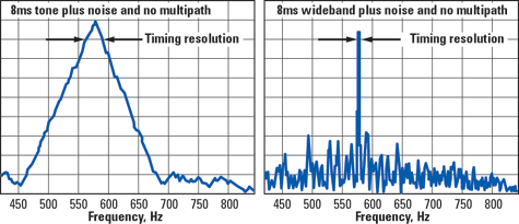 |
| Fig. 5. Timing resolution using tone burst, (left) and wideband (right) signals. |
|
Benefits of wideband technology. Deepwater oilfield developments require highly accurate seabed positioning that can often only be achieved using LBL acoustic positioning techniques. The limitations of tone-burst signals meant that obtaining the highest positional accuracy in the last generation of LBL equipment required use of the Extra High Frequency band. Using EHF systems in water deeper than about 1,600 ft is complicated by the fact that it is not possible to range to seabed transponders from a surface vessel, because EHF signals attenuate rapidly.
Even if it were possible to receive the signals, a separate, dedicated transceiver would be required, since the transponders operate outside the Medium Frequency (MF) band employed by the majority of USBL systems. The increased ranging precision offered by wideband signals means that it is possible to obtain positional accuracies at MF that were previously obtainable only at EHF. This has the combined benefits of extending the range of high-accuracy positioning and rationalizing equipment inventories.
High-speed robust telemetry. A key benefit of wideband technology lies in its application to telemetry where tone burst systems offer limited scope for optimization. In addition to being 10 times faster than the fastest tone-burst telemetry scheme, the robust wideband link incorporates forward error correction and all of the recognized benefits associated with correlation signal processing, in terms of immunity to noise and multipath.
In contrast to the schemes employed in many acoustic modem products, it does not require the overhead of a training sequence, which reduces the latency associated with the data. This makes it more appropriate to real-time monitoring applications, such as the acoustic telemetry of gyrocompass and attitude data for navigation. Wideband acoustic telemetry offers significant improvements in the efficiency of deepwater operations by greatly increasing the update rate for the positioning of structures as they are deployed to the seabed.
Multi-operation use. The non-interfering properties of wideband signal architectures effectively resolve interference problems that were a feature of conventional acoustic positioning systems. Wideband signals greatly simplify the support of multiple, simultaneous positioning operations within the same frequency band and within interference range. This has significant implications in deepwater oilfield developments, where acoustic systems are increasingly essential.
The majority of deepwater drilling rigs, construction and survey vessels are permanently equipped with USBL acoustic positioning systems. These systems are used for dynamic positioning and for tracking the positions of ROVs and other subsea targets. As economics generally preclude the use of a drilling vessel for a subsea construction program, additional vessels are employed to complete the installation of seabed infrastructure in deepwater oilfield developments. In many cases, the development schedule often results in concurrent drilling and installation activity, which dictates the use of additional vessels for installation operations.
Simultaneous operation of USBL systems that are limited to tone-burst technology, and are within interference range of another similar system, can result in acoustic pollution that may significantly affect positioning performance on both vessels, Fig. 6. Deepwater drilling rigs rely on the integrity of their acoustic positioning systems, and the potential implications of interference with the operation of these systems are extremely serious. Using wideband signals in drilling rig USBL systems effectively mitigates this risk and enables better utilization of the available bandwidth.
 |
Fig. 6. Tone-burst signal (left): filter response showing the effects of destructive interference resulting from two overlapping uncoded signals arriving at the transducer. Wideband signal (right): code-correlation function allows separation of the same two paths using wideband signals. Both direct and multipath signals can clearly be seen.
|
|
Deepwater field trials. In December 2004, the system was used offshore West Africa in Dalia field by Fugro Survey, on contract to Technip Offshore, in 4,400 ft of water. An LBL system comprising five transponders and associated topside equipment was put onboard the construction support vessel, Skandi Inspector. Baseline measurement using wideband signals indicated a precision of 1 cm over a 2,550-ft range.
Spread spectrum. A new, integrated underwater navigation, positioning and data communication system has been advanced by Nautronix, dubbed the Acoustic Subsea Network (NASNet). At its heart is the company’s Acoustic Digital Spread Spectrum (ADS2) technology. This is the culmination of an intensive development program that took six years to develop. It is based on parallel military applications that incorporate similar technologies.
The system operates on some of the same GPS principles already discussed, in that it permits an unlimited number of users both on and below the surface, even in deepwater, to obtain precise navigational data. A minimum of six stations are placed on the seafloor, calibrated, and their positions ascertained. These stations, which can be either battery powered or powered from local sources, transmit information on a regular basis (between once per second to once every 10 seconds). Unlike transponder systems where an interrogation signal has to be transmitted, these receivers only have to receive and, hence, cross-talk and multi-frequency problems are wholly overcome. This means the system is the first unlimited user system for accurate positioning.
Typical applications, which can be concurrent operations, encompass the entire range of surface vessel positioning and subsurface survey operations, including data telemetry.
When operating in deep water, variations in sound velocity will bend sonar signals transmitted at the seafloor toward the surface. NASNetTM stations have the ability to float the transmitting transducer above the main station body that incorporates batteries, electronics, etc., Fig. 7. By using this arrangement, a part of the sonar signal is transmitted toward the seafloor and will continue along it for some distance, while at the same time completely fill the water column. The company says that this arrangement gives a unique advantage, in that the stations can be placed considerable distances apart and, hence, fewer stations are required to cover an extensive area.
 |
Fig. 7. The transmitter floats above the seafloor, offering greater range. If currents cause displacement of the buoy, it is accounted for by detection of the receiver below.
|
|
Ocean currents will move the transducer head relative to the main station body, and this is accounted for using a built-in SBL system, which calculates the offset, sends the information to the main transmission transducer, which in turn sends it as part of the overall signal to the receivers. By this means, high overall accuracy is maintained.
Benefits include the ability to cover a very large area (with six stations, up to 100 km2). Accuracy is 1 m RMS, with optional ultra-high accuracy capability of 10 cm. Single acoustic position reference provides positioning and tracking capability from surface to seabed. Battery life for transmitting stations is at least two years. The permanent grid does not require extensive recalibration. Coherent datum eliminates skew of reference between surface and underwater. The company also says that it can be made to interface to existing systems without significant modifications.
Field trial. The system was successfully tested last year at BP’s Deepwater Atlantis field, which lies in the Green Canyon area of the Gulf of Mexico. A six-station suite was deployed at an average water depth of 6,700 ft. These trials have been the most intense and comprehensive evaluation of the new system’s capabilities yet undertaken, and were completed under the stewardship of BP, whose participation provided not only the deepwater trial site, but also substantial funding of $800,000 and technical assistance. During the trial, lousy weather caused the Sonsub’s 236-ft vessel, HOS Innovator, to use its thrusters at maximum power at times. The NASNet signals were still being received from the seafloor despite the noise. 
|