France: Spatial quality of seismic stacking velocities controlled with geostatistics
France Vol. 226 No. 4 Spatial quality of seismic stacking velocities controlled with geostatistics
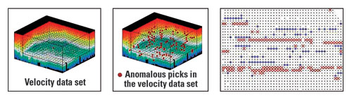
Spatial quality of seismic stacking velocities controlled with geostatisticsLuc Sandjivy, ERM.S (Earth Resource Management SERVICES), Fountainbleau, France The supervision of stacking velocity data sets, whether hand- or automatically picked, is crucial before entering the stack process, itself, or any other pre-stack or post-stack processing, such as migration or depth conversion. Apart from the internal geophysical quality control of the velocity picks, control of the spatial consistency of the data set is an additional useful tool for validating data. Geostatistics provides a quick operational method of assessing the spatial quality of the stacking velocity data sets through computation of a Spatial Quality Index (SQI)* attached to each velocity pick. High SQI values highlight data that are not spatially consistent with their neighbors. These are easily localized and submitted to the supervising geophysicist for interpretation and possible update of the velocity analysis.
Methodology. The spatial quality control of stacking velocity picks relies on the results and interpretation of a 3D geostatistical analysis of raw velocity data. After the standard statistics are computed – such as the number of velocity picks, their average value, variance and histogram, and the cross-plot velocity versus time – the 3D experimental variogram is computed and carefully analyzed. The spatial ranges that are identified on the experimental variogram are interpreted under the geophysicist’s control, in terms of geologically consistent structures and seismic artefact structures. A number of processing artefacts may occur, such as mispicking, change in the picking density or strategy, inline over continuity, etc. The 3D experimental variogram is modeled to reflect the underlying geophysical interpretation of the spatial ranges, as linked to anomalies or to the consistent part of the velocity field. Factorial kriging is then applied at the location of the raw velocity data, to best estimate at each picking location the interpreted artifact, and the consistent part of the velocity pick. SQI is then defined as the ratio between the two kriged estimates – estimated artefact part of the pick/ estimated consistent part of the pick. The display of the high SQI values allows the localization of any possible anomalous velocity analysis. These controls are run quickly, generally within one day; and they do not delay geophysical processing. On the contrary, they contribute to speeding up the process, and to validating the supervisional step, thus bringing additional value to seismic information. Such spatial quality controls have now been developed for other seismic attributes, such as 4D amplitudes, with great operational success.
|
|||||||||||||
- Quantum computing and subsurface prediction (January 2024)
- Mixed outlook for activity on the UK Continental Shelf (December 2023)
- Machine learning-assisted induced seismicity characterization of the Ellenburger formation, Midland basin (August 2023)
- What's new in exploration (March 2023)
- Seismic and its contribution to the energy transition (January 2023)

