Geophysical Applications
Fluid and lithology identification using simultaneous angle-dependent inversion
Results were applied to identify and delineate gas reservoirs in the study area, Burgos basin, Mexico
J. A. Escalera A., V. Mercado H., R. M. Uribe C. and J. Méndez de León, PEMEX; E. Francucci, F. Fernández-Seveso, L. Piccioni and D. Graham, Jason Geosystems
The methodology referred to in the above title, along with hydrocarbon-system analysis, substantially reduces the risk of exploratory and development well placement. On this project, work flow started with a detailed well log analysis based on petrophysical modeling and seismic processing, which provided partial angle stacks of the CDP gathers that were processed using real amplitude and pre-stack time migration.
Volumes of P-impedance, S-Impedance, Vp/Vs, Lambda-Rho, Mu-Rho and Poisson’s Ratio were calculated through a simultaneous inversion process. This process is based on the variation of reflectivity due to the angle of incidence, which is included in the partial angle stacks and Knott & Zoeppritz formulations. These seismic volumes show distinctive behaviors that vary with lithology and fluid content, allowing a superior definition of reservoir and fluids through an integrated volume analysis methodology.
In the study area, a producer gas-charged geobody in the Paleocene Midway was captured, delineated and subsequently validated. With the use of similar capture criteria, additional prospects were identified and validated with depositional systems, migration and charge conduits, and fault-system characterization. Good agreement was achieved between the well results and the simultaneous inversion. A new well was drilled based on this study that matches the predicted lithology and gas content.
INTRODUCTION
The study area, located in Burgos Basin, Mexico (Fig. 1), has a producing gas field with three wells and an exploration tract, where several dry wells in different structural positions have been drilled.
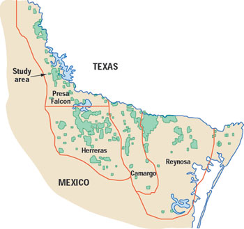 |
Fig. 1. Study area in Burgos basin, Mexico.
|
|
The producing reservoirs are Paleocene Midway turbiditic sandstones filling hemigrabens developed during the late extensional deformation phase of Cretaceous rocks.
The objective of this study was to delineate and characterize the producing reservoirs in the area based on interpretation of results from Simultaneous Angle Dependent Inversion (SADI) and to identify exploration/development opportunities.
DATA CONDITIONING/PROCESSING
A three-step procedure was followed to condition and process the data. First, the P-wave 3D seismic data was reprocessed with amplitude preserved. Gathers were conditioned and pre-STM was done, then three partial-angle stacks ranging from 8° to 30° were obtained, Fig. 2.
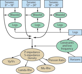 |
Fig. 2. Generalized workflow of Simultaneous Angle Dependent Inversion.
|
|
Next, log editing, calibration and modeling were performed. Based on the wells with a complete suite of logs, Vp, Vs and Rhob1 were modeled for every well of the project. Fluid-substitution analysis was performed to evaluate differences in shear impedance and acoustic impedance (normal incidence) in reservoir sands.2 Log modeling results are aimed at predicting reservoir lithology and fluids and to assure accurate wavelet extractions.
Last, SADI processing was applied. Three partial angle stacks (8 – 18°, 12 – 24°, 18 – 30°), constraints and a well-log-based low-frequency model were used as input data, Fig. 2. Based on the application of Zoeppritz or Aki & Richards3 equations, P-impedance, S-impedance and density cubes were simultaneously obtained through SADI. Derived volumes of Vp/Vs, Poisson’s Ratio, Lambda-Rho and Mu-Rho were also computed, Fig. 2.
LITHOLOGY/FLUID CHARACTERIZATION
Information related to shear wave velocity obtained from SADI substantially increased the ability to identify fluids and lithology. Multiwell and multivariable cross-plots derived from well logs and SADI allowed fluid and lithology characterization. P-Impedance (PI), S-Impedance (SI), Poisson’s Ratio, Vp/Vs, Mu-Rho and Lambda-Rho were cross-plotted and the polygons defining the functional relationships of gas sands were interpreted (Figs. 3a and 3b).
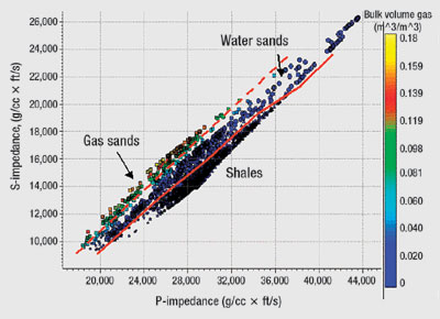 |
Fig. 3a. Single well cross plot of acoustic impedance vs. shear impedance. Gas and water bearing reservoir sands can be separated. Color coding is Bulk Volume Gas.
|
|
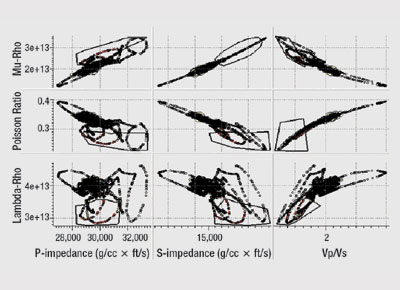 |
Fig. 3b. Multiwell multivariable cross-plots. High resistivity sands (gas sands) are captured by the polygons.
|
|
P-wave velocity is affected by fluid content in the reservoir and so is P impedance, Poisson’s Ratio, Vp/Vs and Lambda-Rho. In this study, a combination of Lambda-Rho and Mu-Rho was used to spot gas-charged sand compartments. High values of Mu-Rho proved to be related to clean sands and low values of Lamda-Rho pointed out gas presence. Also, Vp/Vs and Poisson’s Ratio demonstrated to be good fluid indicators, Figs. 4 and 5.
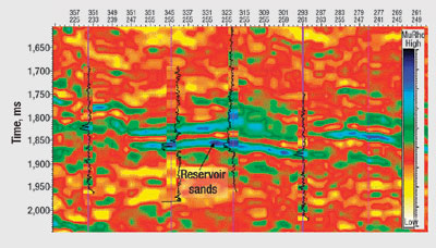 |
Fig. 4. Mu-Rho N-S section through the gas field. High values of Mu-Rho (blues) relate to cleaner sands while shales show low values (orange and yellow).
|
|
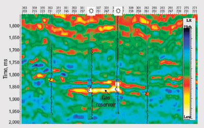 |
Fig. 5. Lambda-Rho section through the gas field. Low values of Lambda-Rho (yellow) relate to gas presence in the reservoir.
|
|
Mu-Rho clearly shows the sand bodies facilitating the interpretation of depositional geometries and sand content of the reservoirs. Lambda-Rho has substantially lower values in the neighborhood of the producing wells, confirming its value as fluid indicator.
The match and tie between seismic and wells is very precise. The values of Mu-Rho and Lambda-Rho derived from well data are directly and quantitatively compared to the results of SADI and since the results of the inversion are not derived from well data, the well to seismic match indicates the quality of SADI.
Geobody capture. Functional relationships from well data were applied to the SADI output cubes to isolate the cells satisfying the pay zone conditions. Geobodies were subsequently generated by applying minimum size and connectivity criteria, Fig. 6. Once the geobodies of interest were selected, structural top/base and thickness maps were generated. The volume of each geobody was then obtained by adding those cells, while honoring pay functional relationships and face-connectivity criteria.
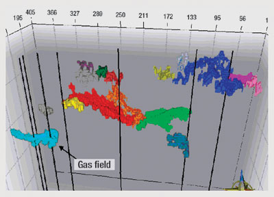 |
Fig. 6. Geobodies honoring pay functional relationships and face connectivity criteria.
|
|
Geobodies were validated by analyzing their consistency with respect to the field compartments, geological model, hydrocarbon migration and volumetrics. Finally, the results were used to define exploratory prospects.
Play concept. The Paleocene Midway in the study area was deposited during late rift stages in a NNW-SSE hemigraben, produced by extensional structuring of Cretaceous rocks. The objective stratigraphic section is composed of marine deposits where sands were driven by gravity flows down to the basin floor. Reservoir sands form by stacking of thick beds that thin up toward distal zones to the east and southeast.
Average gross thickness of the producing reservoir in the study area is 30 m, and net reservoir is around 14 m with good porosity values. Average depth to objective is 2,900 m, Fig. 7.
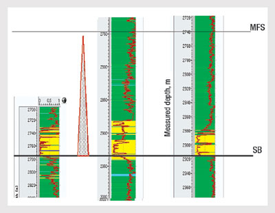 |
Fig. 7. Producing reservoir shown in gamma ray log.
|
|
The structure is characterized by normal and reverse faulting at different angles, with patterns suggesting regional dextral strike-slip efforts. Different styles and faulting intensities are observed. The transpressional-transtensional features that connect the reservoirs directly with Jurassic-Cretaceous source rocks are especially relevant.
Faults play a significant role in developing permeability barriers. Compartmentalized reservoir fluids are evidenced by the presence of different pressure and water salinities in the different fault blocks. Overpressured and compartmentalized gas accumulations are found below an effective regional seal. Consequently, producing reservoirs may be found in different structural positions.
The geobodies defined and selected during the analysis were ranked according to their volume and the factors controlling compartmentalization and hydrocarbon charge.
Compartments A, B and C meet the conditions to be gas-charged geobodies according to the criteria applied during geobody capture, Fig. 8. A, B and C are in different structural positions, isolated by faults, and in favorable zones with respect to hydrocarbon migration and charge conduits.
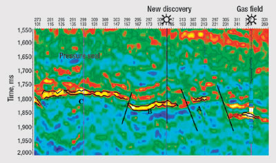 |
Fig. 8. Lambda-Rho. E-W through the gas field and prospective areas. Black horizons are top and base of geobodies identified and captured using multiwell, multivariable crossplots (Fig. 3). A, B and C: exploration prospects.
|
|
CONCLUSION
- The higher resolution of the layer model derived from SADI provides a better well to seismic tie to support reservoir characterization.
- The use of variables related to shear wave velocity derived from SADI substantially increases the ability to define fluid and lithology.
- The reservoir sand distribution inferred from lithology indicators is consistent with the interpreted depositional system and relates to a sedimentary source from west and northwest.
- Well production data coincides with the fluid and lithology indicators derived from SADI.
- Transtensional-transpressive faulting plays a main role as hydrocarbon migration conduits.
A well was sited and drilled based on this study. The results of that well are in agreement with the lithology and gas content predicted from the Simultaneous Angle Dependent Inversion conducted in this study. 
ACKNOWLEDGEMENTS
The authors thank PEMEX Exploración y Producción for authorizing this work.
LITERATURE CITED
1 Xu S. and R. White, “A new velocity model for clay sand mixtures,” Geophysical Prospecting. V.43, p.91, 1995.
2 Gassmann, F., “Elasticity of porous media,” Vierteljahrschrift Der Natur, for Schenden Gesellschaft,. V. 96, p. 1, 1951.
3 Aki, K. and P.G. Richards, Quantitative seismology: Theory and methods, v. 1: W.H. Freeman and Co., 1980.
THE AUTHORS
|
| |
Victor Mercado H. earned a geophysics degree and then an MSc in exploration engineering. He has more than 15 years in oil and gas exploration in Mexico involving gravity-magnetometry and seismic. He specializes in AVO and seismic inversion processing and interpretation, and works as a geophysicist for PEMEX Exploración y Producción.
|
|
Rosa M. Uribe C. graduated as geologist and earned an MSc in seismology. She joined PEMEX Exploración y Producción in 1997 and works as an interpretation geologist, conducting integration of subsurface data and prospect generation in Western Burgos basin.
|
|
Javier Méndez de Léon graduated as a geologist and specialized in petrophysics. He has over 13 years’ experience in the sedimentary basins of Northern Mexico, involving surface geology, prospect generation, well log analysis, integration of core/drill cuttings data and production test results. He works for PEMEX Exploración y Producción.
|
|
Eduardo Francucci has worked for more than 20 years in the oil industry through operating and service companies in exploration and development teams. He runs seismic inversion, geostatistics and reservoir characterization projects for Jason Geosystems in Latin America.
|
| |
Fernando Fernández-Seveso has over 16 years’ experience in the Latin American oil and gas industry. He has been involved in exploration of frontier areas, re-exploration of mature areas, and field development. He runs seismic inversion and reservoir characterization projects for Jason Geosystems in Latin America.
|
|
Luis Piccioni has worked in the oil industry for over 15 years, specializing in integrating geology, geophysics and reservoir engineering for reservoir characterization projects, development plan design, and prospect generation. He runs seismic inversion and reservoir characterization projects for Jason Geosystems in Latin America.
|
|
David Graham has a long history of reservoir characterization, working through oil companies, service companies and as an independent contractor. Since joining Jason Geosystems, he has worked actively on projects throughout the world, and is currently running the Far East for Jason. He can be reached at: dgraham@jasongeo.com.
|
|

