Passive surface geochemical survey leads to dry gas discoveries
ExplorationPassive surface geochemical survey leads to dry gas discoveriesWhen searching for dry gas, don’t look for methane. Instead, focus on ethene and higher molecular weight compoundsAndrei Viforeanu, GEOMED Impex 2002 S.R.L.; Wayne Wells and Jay W. Hodny, W. L. Gore & Associates, Inc. A surface geochemical exploration method that uses a passive hydrocarbon sampling technology has been successful in locating several dry gas deposits in the Transylvanian and Carpathian mountains of Romania. The method is designed to detect organic compounds larger than methane, even though, by definition, dry gas is composed primarily of methane. Since there are numerous noncommercial sources of methane, including near-surface sources, relying solely on methane measurements could lead to unproductive drilling. For the most accurate results, the Romanian surveys focused on locating ethene (an olefin hydrocarbon) and heavier hydrocarbons, compounds found in conjunction with methane in dry gas. Although these compounds constitute only about 1% of the gas that was being explored for, they are important components of the geochemical signature and model. Hydrocarbon samplers were placed in the exploration areas and near existing wells – both producing and dry – to develop a geochemical pattern against which samples from the exploration areas could be compared. The fieldwork was followed by extensive laboratory analysis of the samples, using thermal desorption, gas chromatographic separation and mass selective detection. The data derived from the analyses were then compiled, processed and modeled using proprietary discriminant analysis and pattern recognition techniques. The probabilities of each sample’s resemblance to the composition of the local natural gas were then determined and mapped to identify the locations with geochemical anomalies most likely to yield underground reservoirs of dry gas. To date, 12 wells have been drilled (one still drilling) on sites identified from the surveys, conducted since 1999. All 12 encountered natural gas. For a national economy with limited financial resources, the surveys have minimized economic and exploration risks and provided significant benefits: dry holes were avoided and the gas being produced is helping the country reduce its dependence on imported gas. For the sampling technology, the survey results demonstrate that it is possible to explore for, and find, natural gas using surface geochemical techniques – specifically, passive hydrocarbon sampling. INTRODUCTION Romania has Europe’s longest history of natural gas exploration and production. In 1909, the continent’s first gas deposit was discovered at Sarmasel in the northwest Transylvanian basin. Maximum production of 29.8 Bcm (Bm3) was achieved in 1976. Today, gas provides about 40% of the country’s energy needs.1 However, Romania’s energy needs exceed its domestic supply. The country has been importing gas from Russia since 1979, in continually increasing amounts and at rising prices. In 2000, about 2.5 Bcm of imported Russian gas cost about $120 per 1,000 m3. In addition, conditions within the country support increasing local energy production. Average drilling costs are a moderate $500 per meter, and the exploration drilling success rate for the national gas company, S. N. G. N. ROMGAZ S. A., is a remarkable 75%.2 The potential gas supply in Romania provides a further incentive to expand local production. In 2000, the United States Geologic Survey estimated there were about 153 Bcm of undiscovered gas reserves in Romania. These reserves are located in two primary areas, 59 Bcm in the Transylvanian basin and 62 Bcm in the Romanian flysch zone.3 ROMGAZ has estimated there are 20 Bcm of undiscovered natural gas reserves in the Transylvanian basin.2 For assistance in capitalizing on its incentives and potential, ROMGAZ turned to a non-Romanian exploration company in 1999, W. L. Gore & Associates, Inc., to conduct passive hydrocarbon sampling surveys in prospective areas located in the country’s central and northeastern regions. The surveys used the most recently developed surface geochemical techniques in identifying underground dry gas deposits. To date, 16 areas in Romania have been surveyed using this technique. Surface geochemical techniques have evolved significantly since the early 1900s, when they relied on direct measurement of methane and ethane (an aliphetic hydrocarbon) concentrations in soils and/or flux measurements to monitor the leakage. Over the next 50 years, a number of advances were developed that included active soil gas sampling (using vacuum pumping) for detecting methane and a limited range of light hydrocarbons, and acid extraction of soils. Other methods included flux and concentration measurements of the lightest organic and sometimes inorganic compounds coupled with compound ratio mapping, and microbial techniques. The most recent technological milestones, employed in the Romanian surveys, include the use of an adsorbent-based passive hydrocarbon sampling technique, conducted on site, over a period of time. This approach directly detects active hydrocarbon microseepage, which is the process of vertical hydrocarbon migration from underground deposits to the surface. The pattern and behavior of hydrocarbon microseepage has been well documented and forms the empirical evidence on which surface geochemical modeling is based.4 The resulting dataset, rich with numerous organic compounds, can be modeled statistically and used to find potential gas and oil producing areas. Prudent integration of this geochemical data with geological and geophysical data of the region of interest will yield a more reliable classification of prospectivity, thereby lowering exploration risk. GEOLOGY AND STRATIGRAPHY Romania, located in southeastern central Europe and bordered on the east by the Black Sea, is dominated by the Carpathian Mountains, a southeastward extension of the Alps, Fig. 1. The topography comprises 36% hills and tablelands, 32% plains and 32% mountains.5 It remains tectonically active, with the most severe earthquakes occurring in the south and southwest areas. Additionally, its geologic structure and climate are conducive to landslides.
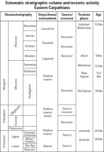
The Carpathians form a triangular block surrounding the Transylvanian basin. The eastern Carpathians, which have a northwest-southeast orientation, include an outer flysch band and an inner band of crystalline and volcanic rocks. In the south, the Carpathians run east-northeast to south-southwest and are comprised primarily of metamorphic rocks. Orogenic activity continued along the outer flanks of the Carpathians until the late Tertiary, approximately 10 million years ago. This activity produced folding and upheaval of the sedimentary rocks within the sub-Carpathian depression and resulted in formation of an adjoining lower range, sometimes called the sub-Carpathians. Fig. 2 illustrates the stratigraphy of the region.
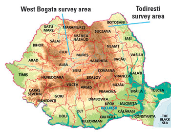
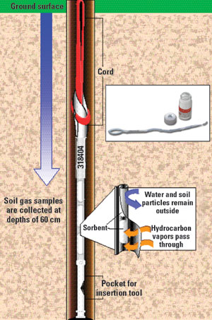
The passive hydrocarbon-sampling surveys were conducted in two main regions: Todiresti and West Bogata, Fig. 1. The Todiresti region is located in Exploration Block RGO 4 on the Moldavian platform in northeastern Romania. The West Bogata region is located in the Turdas area in Exploration Block RGO 2, in the western Transylvanian basin. The Moldavian platform, the location of the Todiresti survey, is part of the East European platform. It consists of a Lower Proterozoic midgrade metamorphic basement comprising gneisses with intrusions of gabbros, anorthosites and granites, with a sedimentary cover laid down during several cycles: the Verdian-Cambrian, Ordovician-Silurian, Devonian, Upper Jurassic-Cretaceous Eocene and Oligocene. In this area, gas entrapment was anticipated at target depths of up to 1,000 m in the Sarmatian formation, along a structural high associated with a normal fault.2 The Transylvanian basin, where the West Bogata survey occurred, is a molasse depression of Neogene age, developed above the deformed Carpathian units and their post-tectogenic cover. Deposits of Upper Cretaceous-Paleogene, Miocene and Pilocene sediments, as well as a salt layer in the lower Badenian and volcanic tuffs, are located at different levels. Presently, gas is produced in two fields within the survey area, Bogata in the northeast and Sancel in the south.2 In this location, gas entrapment was anticipated in the Badenian and Sarmatian formations in two areas that contained anticline closures along three north-south anticlinal alignments that are associated with an overthrust fault system, and in a southern structural extension of Bogata field. The anticipated target depths2 ranged to 1,000 m. Seismic and geochemical evidence supports the idea of structural charge in other areas of Romania (e.g., North Moldavia, Stupca, Varvata, Liteni and Ursoaia) that have not been drilled. Southern Romania, Muntenia, has seismic and geochemical evidence of gas charge in several areas including Girbovi, Firbinti and Ursiceni. THE SURVEY Passive hydrocarbon sampling surveys were conducted using patented Gore* Modules, Fig. 3. These Modules contain engineered sorbents that are encased in an expanded polytetrafluoroethylene (ePTFE) membrane, which is chemically inert and hydrophobic (waterproof), yet vapor permeable. The Module acts as a passive sampling device, allowing organic vapors to pass through the membrane freely and collect onto the engineered sorbents. Liquid water and soil do not come into contact with the sorbent, protecting and ensuring sample integrity.
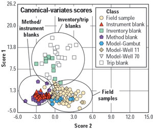
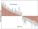
Survey design. The Todiresti survey included three areas, each about 40 km2. In West Bogata, a significantly larger area of approximately 800 km2 was surveyed. A total of 964 Modules were placed in the two survey areas, spaced 500 – 1,000 m apart. An insertion tool was used to create narrow diameter holes to a depth of about 60 cm into which the Modules were inserted. Portable GPS was used to record each sample location. For statistical modeling purposes, Modules were also placed near existing wells to obtain data on the hydrocarbon characteristics of known producing and non-producing areas. All of the Modules were left in place for 17 days. This time-integrated sampling technique was designed to minimize near-surface variability and maximize sensitivity to a wide range of organic compounds (up through C18). In addition, a number of Modules were selected as blanks for quality control purposes. Inventory blanks were retained at the laboratory to establish a Module-baseline signature subsequent to their manufacture. Unburied and unopened trip blanks accompanied the field-exposed Modules during shipment to and from the laboratory to track variations resulting from transit. Additional quality assurance (QA) blanks documented conditions within the laboratory during Module analysis. Laboratory analysis. After the 17-day passive sampling period was completed, the field-exposed Modules were retrieved and returned to the laboratory for analysis by thermal desorption, gas chromatographic separation and mass selective detection (TD/GC/MS). Stringent quality control standards were maintained throughout the analyses to ensure the validity of all results. A canonical variate analysis of all the samples (Fig. 4) indicated distinct similarities within each sample class and distinct differences between the various classes. The QA blanks and field samples grouped into three distinct clusters. This clustering indicated that the geochemical signature of field-exposed samples was indeed different from that of the various classes of QA blanks. As a result, they were deemed acceptable for further processing and geochemical modeling using discriminant analysis and pattern recognition techniques.
The analyses targeted a total of 79 compounds, including the n-alkanes from ethene through octadecane, plus key representative compounds from several other hydrocarbon classes such as alkenes, cyclics and terpenes. Based on the significance of the target compounds relative to the geochemical signatures of the gas being explored for, geochemical models were developed for each survey area, Fig. 5.
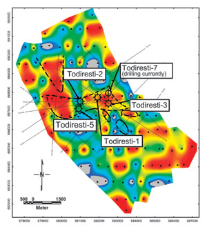
The geochemical model. After the laboratory data are accumulated, it is possible to delineate areas of similar geochemical signature that correlate with known reservoir geochemical signatures. Sophisticated multivariate statistical methods are used to create a geochemical model that applies field data to known hydrocarbon microseepage behavior. Principal component analysis reorients the data based on chemical variances or patterns. Discriminant analysis identifies the data components or patterns that differentiate between background samples and those that were potentially productive, and simultaneously determines the probability of each field sample’s resemblance to the local natural gas. These probability values were then compiled and mapped. Survey-dependent anomalous thresholds for each site were determined and used in conjunction with available geological and geophysical information to identify the most promising sites for drilling. RESULTS To date, 12 wells have been or are being drilled in the two regions in Romania at sites identified with the aid of the passive hydrocarbon sampling surveys. In the Todiresti area, four dry gas discovery wells have been drilled (Fig. 6), and drilling is underway on a fifth well. The four discoveries, Todiresti-1 through 5, have perforated intervals that vary from 962 to 1,127 m (3,150 to 3,700 ft), with tested flowrates ranging from 59.5 Mm3/d (2.1 MMcfd) to 66.9 Mm3/d (2.4 MMcfd).
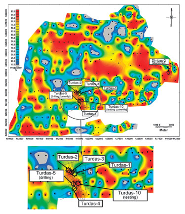
It must be emphasized that the mapped geochemical anomaly distribution represents a purely mathematical interpretation of the probability data surface, and is governed only by the actual data values, sample layout geometry and data density. No geological fabric or boundary conditions were considered in the mapping process. The geochemical results were then integrated with the available geological and seismic data, revealing a clearer interpretation of hydrocarbon prospectivity in the several areas identified by ROMGAZ. For example, the apparent geochemical negative in which the Todiresti-5 and Todiresti-2 wells were drilled is a mathematical interpretation of the hydrocarbon data surface based on the presence of low model probability values immediately north and south of these two wells, Fig. 6. However, reasonable seismic data coverage in this area indicated that there were several discrete target sands packages, one of which could be mapped as a narrow unit between the low probability sample points (where the sand packages were absent). In West Bogata, seven wells have been drilled, Fig. 7. Turdas-1 has a perforated interval of 700 – 715 m (2,300 – 2,350 ft) and a tested flowrate of 20.0 Mm3/d (706 Mcfd). Dimbau-2 tested positive for gas but had to be abandoned due to deviation of the well into a fault (main objective missed). Turdas-2, 3 and 4 encountered dry gas in non-economic quantities. Testing is underway on Turdas-10, while Turdas-5 is being drilled.
CONCLUSIONS The results from the passive hydrocarbon sampling surveys have clearly proven to be beneficial to ROMGAZ and the country’s economy. Gas was encountered at all 12 selected drill sites, and the eight producing wells have established commercial flowrates. Although gas in the region was known to be more than 99% methane by volume, the passive hydrocarbon sampling surveys identified accumulations of gas at depth, based on the presence or absence of 79 organic compounds in the near-surface soil gas. Methane tends to be ubiquitous in the environment. Any surface geochemical method focused solely on methane measurements will indicate variation in flux levels not necessarily correlated to subsurface gas accumulations. Therefore, by analyzing for a wide range of target compounds comprising dry gas, including trace constituents and secondary compounds, the passive hydrocarbon sampling surveys proved effective for and capable of finding dry gas without the need to report or rely on methane values alone. The eight new producing gas wells provide clear evidence of the effectiveness of this survey in these types of demanding and challenging applications.
|
|||||||||||||||||||||||||||||||
- Quantum computing and subsurface prediction (January 2024)
- Mixed outlook for activity on the UK Continental Shelf (December 2023)
- Machine learning-assisted induced seismicity characterization of the Ellenburger formation, Midland basin (August 2023)
- What's new in exploration (March 2023)
- Seismic and its contribution to the energy transition (January 2023)
- First Oil: Sorting through the muddled mess (November 2022)
- Applying ultra-deep LWD resistivity technology successfully in a SAGD operation (May 2019)
- Adoption of wireless intelligent completions advances (May 2019)
- Majors double down as takeaway crunch eases (April 2019)
- What’s new in well logging and formation evaluation (April 2019)
- Qualification of a 20,000-psi subsea BOP: A collaborative approach (February 2019)
- ConocoPhillips’ Greg Leveille sees rapid trajectory of technical advancement continuing (February 2019)

