 Technology from Europe: Technology from Europe:
Italy
Recent developments in exploration/ characterization of marine environments F. Gasparoni and D. Calore, Tecnomare SpA
Technology, and technology innovation in particular, introduces new capabilities or allows oil functions to be performed with greater efficiency. Since the early 1990s, Tecnomare has been in the forefront of the development of advanced solutions for exploration and characterization of marine environments, bridging the gap between the practice of offshore technology and the possibility of developing engineered technologies for scientific investigation. Main achievements include:
- Seafloor observatories for long-term multidisciplinary monitoring of abyssal sites
- Benthic stations for various purposes (like sediment transport, monitoring of gas occurrence from seafloor)
- Adaptation of instruments for operation underwater in the most critical conditions (water depth, temperature, etc.)
- Moored buoys for measurements at the air-water interface
- Monitoring networks, and
- Special instrumented modules for execution of sampling, surveys and measurements.
These systems have been qualified in real operational conditions, often characterized by criticalities like depth (up to 4,000-m water depth), temperature (Antarctic conditions), and environment (the harmful brines of the Eastern Mediterranean anoxic basins).
Mostly developed in the context of scientific programs for geophysical, oceanographic, and biotechnological applications, these technologies represent promising solutions also for the offshore industry, as it expands to new sites, in an era of increasing environmental awareness. The following discussions overview these achievements.
Deep seafloor observatories. From the scientific point of view, the deepwater environment represents the ultimate frontier for earth observation and understanding fundamental processes (solid earth studies, as well as oceanographic, climatic and environmental investigations). Specifically, the continental margin is a critical environmental interface – a fundamental Earth discontinuity – where terrestrial, marine and atmospheric processes converge and mutually influence one another across a number of spatial and temporal scales. Development and operation of seafloor observatories, defined as “unmanned systems at a fixed site in the ocean providing power, control and communications to sensors located nearby,” is now recognized as the essential approach to achieve full-time presence at the deep seafloor and overcome limitations of traditional ship-based approaches. National and international efforts are ongoing to solve the challenging technological issues.
A result of the joint effort of scientific organizations and industrial companies, GEOSTAR is the first European deep-sea observatory capable of acquiring oceanographic, geophysical and environmental data down to 4,000-m water depth, with up to one year autonomy. It comprises communication systems, data acquisition and control electronics, and the deployment and recovery vehicle. In August 1998, it was deployed for the first time in the Adriatic Sea at 42 m wd, and operated continuously for 450 hr. The first long-term scientific mission was in the Tyrrhenian Sea, close to Ustica island (Western Sicily), at 2,000 m wd. Starting in September 2000, 4,159 hr of continuous data were collected. The system was deployed/recovered by the R/V Urania, managed by the Italian Consiglio Nazionale delle Ricerche.
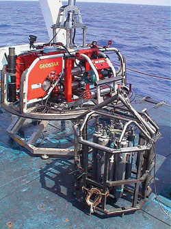 |
Special module developed by Tecnomare for exploration of anoxic basins (front) and the GEOSTAR carrier vehicle (rear).
|
|
Toward seafloor monitoring networks. The success of GEOSTAR opened the road to initiatives aimed at establishing permanent, deep-seafloor infrastructures, extending observation capabilities of geophysical/seismological shore networks. In particular, SN-1, the first node of the Italian submarine seismological network, was deployed in October 2002 in Eastern Sicily, 20 km offshore Catania, in 2,105 m wd. Basically it is conceived as GEOSTAR and handled by the same vehicle. After conclusion of its first autonomous operation, SN-1 will be connected to a submarine cable made available by the Italian National Institute for Nuclear Physics (INFN). This will completely integrate it into the existing Italian shore network, and contribute significant knowledge of geophysical phenomena (seismic and volcanic) characterizing eastern Sicily.
Benthic stations are instrumented stations designed to accomplish at seabed simpler tasks than the seafloor observatories. A possible use, integrated to other complementary systems such as moored buoys and towed vehicles, is collection of the basic information to assess impacts of various phases of oil and gas exploitation. In a project supported by ENI, Tecnomare has developed TRIAS, a BENTHIC tripod aimed at collecting information concerning the benthic boundary layer.
Recent availability of methane and other gas sensors suitable for operation in seawater opens the possibility to define new applications for benthic stations, oriented to monitoring of gas from the seafloor. The GMM (Gas Monitoring Module) – under development by Tecnomare and Istituto Nazionale di Geofisica e Vulcanologia in the framework of the EU ASSEM project – can be used for characterization/monitoring of a specific site, e.g., an offshore structure or a subsea system to be installed. First use of GMM is foreseen in 2003 – 2004 in the Corinth Gulf (Greece) within shallow pockmark fields.
Sensor adaptation. One main factor limiting full exploitation of the potential of automatic monitoring systems for marine environments is availability of adequate sensors rated for deep water and capable of maintaining performance over long time periods. Although, in some cases, sensor technologies are adequate for such purposes, in many cases they are not sufficiently reliable to provide off-the-shelf solutions. In some cases, the problem is limited to applying specific tailored solutions to sensors already qualified for terrestrial applications; other cases call for integration of sensors into entirely new systems. The short life of chemical sensors in seawater can be overcome by developing analytical robots capable of preserving and self-calibrating sensors through use of circulation loops and solutions. A prototype chemical analyzer has been developed by Tecnomare and INGV, and successfully field tested.
Moored buoys. Observation at the air-water interface and on the water column is another key element of any monitoring system aimed at baseline determination and impact control in offshore sites. Moored buoys represent the traditional solution for this purpose; and Tecnomare's most significant experience is BOMA (Boa Mediterranea per Alte profondita), the first Italian buoy designed to requirements of Operational Oceanography. BOMA is a deep-sea, moored buoy aimed at providing meteorological, oceanographic and water quality measurements in a continuous/automated mode.
An original solution has been developed to characterize physical, chemical and biological parameters along the water column without requiring sensors on the mooring line. A special module automatically selects the sample level and transfers the sample to a measurement chamber located onboard the buoy. This system has been tested/qualified on the coastal buoy MEDUSA, developed in the framework of the ENI-funded SECIS project. BOMA was to be installed in the Southern Adriatic Sea in spring 2003 and become part of a measuring network at Mediterranean scale.
Special modules. A significant example of marine engineering work applied to the exploration of extreme environments is represented by the special-purpose instrumented module developed by Tecnomare in the framework of the EU-project BIODEEP (BIOtechnologies from the DEEP) project. The problem to solve was to answer requests from scientists to take samples, video images and measurements in particularly hostile environments found in a few deep areas of the Mediterranean Sea, at depths exceeding 3,000 m; five basins have been identified. The module developed by Tecnomare (SCIPACK) incorporates solutions like: real-time transmission to surface of all scientific data, video images and status parameters; remote control of samplers; and material/component selection aggressive environments.
SCIPACK is managed by the same deep-sea vehicle developed for the GEOSTAR observatory through a short (secondary) umbilical. In this way, the vehicle, remaining outside the brines, guides SCIPACK into the brines in a fully controlled way, while real-time data and image telemetry creates the virtual presence of the scientists on the site. The system was used in 17 dives to water depths of 3,300 to 3,700 m, in August/September 2001.
Data acquisition/control systems. Although capacity of observing the marine environment relies on many different technologies, the heart of all the systems described is the data acquisition and control system, representing the enabling technology for developing marine monitoring systems and networks.
Long autonomy, high reliability, capability to manage a wide range of sensors/devices, and operation in critical conditions are basic requirements that triggered development of a dedicated hardware for: data acquisition/mission control; power management/control; and status-parameters monitoring. This hardware can be applied in a wide range of remote autonomous instrumented systems. Tecnomare's present state-of-the-art is well represented by a system developed to fit into a 150-mm ID, 760-mm long vessel, rated for 6,000 m wd. To meet requirements of surface stations, like moored buoys or fixed platforms, the hardware can be configured to manage communication devices like cellular phones, satellite or radio modem, GPS receivers (see accompanying figure).
In summary, optimum management and correct/safe use of marine resources require development of effective monitoring tools and growth of knowledge of the environmental processes, either natural or man-induced. Together with parallel development of analytical tools and descriptive/forecasting models, they must constitute the scientific and technological basis for every decisional procedure. At the same time, systems must operate at sea under possible extreme conditions. Examples noted illustrate that technology is ready to allow for real-time operating scientists to be substituted by real-time autonomous systems.
This summary report overviews the major review in the OMC copyright 2003 paper “Tecnomare activities in the exploration and characterization of marine environments – an overview,” by authors F. Gasparoni and D. Calore, presented at the Offshore Mediterranean Conference and Exhibition, Ravenna, Italy, March 26 – 28, 2003. The original, 10-page paper contains more detailed discussions, two tables of data, six illustrations, and eight reference publication/studies. 
|

