Tectonic setting of the world's giant oil fields
EXPLORATION & EXPLOITATIONTectonic setting of the world’s giant oil fieldsPart 1 – A new classification scheme of the world’s giant fields reveals the regional geology where explorationists may be most likely to find future giantsPaul Mann and Lisa Gahagan, Institute for Geophysics, University of Texas at Austin; and Mark B. Gordon, GX Technology
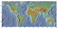
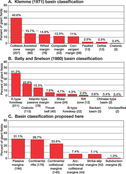
Introduction A "giant" oil field is defined as one containing proved reserves exceeding 500 million bbl; a giant gas field contains proved reserves of greater than 3 Tcf.2 "Reserves" refer to the ultimate recoverable amount and include the amount produced to date. Some fields are giants only when viewed on a boe basis.3 North American giant fields (without field outlines) were digitized from Carmalt and St. John’s published compilation.3 Field locations and outlines are derived from the Petroconsultants SA digital database for non-North American giant fields (used with permission). The 592 giant fields of the world cluster in 20 regions (Fig.1), with the densest occurrences in the Arabian Peninsula and the West Siberian basin. One field name might be associated with multiple sub-giant fields. For example, Oficina field in Venezuela would correspond to fields numbered 539 – 546. That is, the authors counted these as one giant field, partly because the sub-fields are beyond the resolution of the maps. Hence, 592 fields are significantly less than the total (700+) number of fields that were examined in the Petroconsultants database. Detailed geologic maps of these regions are modified from the Exxon Tectonic Map of the World.4 Seven of these regions appear in this article; the others will be discussed in Parts 2 and 3. Significance and Exploration Trends Of all giant reserves, three-quarters are found in the Middle East, Latin America and Asia-Pacific; OPEC countries account for just over half; while OECD countries comprise only 15% of combined giant field reserves.5 Overall, the discovery rate of giant oil fields has decreased globally since the late 1960s, indicating that the Hubbert cycle of oil resource is in a mature phase.3 However, discovery of giant gas fields has continued to increase during the 1970 – 2000 period.2 There is an overall increase in the recoverable oil volume of well-known giant fields between 1981 and 1996.1 Of the 37 oil giants and 40 gas giants discovered in the 1990 – 2000 period, 15 were in deep water.2 Greater numbers of giant fields are being discovered as a result of their stratigraphic emplacement, as opposed to a strictly structural-trap environment. Basin Classification All giant fields occur in basins that have experienced several different structural and stratigraphic phases related to changing plate tectonic boundary conditions. There are two approaches. One can assume, like Pettingill, that present-day basin style is representative of past basinal types, including those possibly responsible for formation of giant fields.5 A second, more difficult, approach is to infer the basin style most responsible for one or more of the complex factors forming the giant, including: 1) formation of source rocks; 2) formation of reservoir rocks; and 3) creation of structural and stratigraphic traps. These events could have occurred in completely different settings. For example, the source may have formed during a rift phase, the reservoir may been deposited during a passive-margin phase, and the structural trap may have formed during the collision of a continent or island arc with the passive margin. For the classification shown on Fig. 2c and the subsequent maps, the authors have followed the second approach, with emphasis on identifying the basin-forming tectonic and stratigraphic phase responsible for source-rock deposition and/or structural trap. For elongate giant fields aligned with fold and thrust structures, an exception to this rule was made: Assume that these giants are predominately related to shortening at collisional margins (e.g., Arabian Peninsula).
Previous / Revised Classifications Comprehensive tabulations of names, locations, sizes and gas/oil ratios of giant fields have been previously compiled and updated by various groups. Halbouty has made periodic, decadal assessments of giant fields for the 1960 – 2000 period.2,6,7,8 Early studies also include Nehring, who listed giant oil fields but did not consider discoveries after the end of 1975.9 Carmalt and St. John compiled a comprehensive list of 509 giant fields through 1983.3 They classified the tectonic setting of giant fields using the basin classification of Klemme.10,11 Their results are plotted as a histogram in Fig. 2a. According to Klemme, whose classification is widely cited in petroleum literature from the ’70s and ’80s, basins are divided into five major categories according to their tectonic history. Collision zones and accreted margins were the interpreted setting for more than half of the 509 basins included in the survey, with rifted margins accounting for only about 15% of giant fields. Bally and Snelson divide basins according to three main tectonic categories.12 The categories depend heavily on the degree to which a basin is associated with a "megasuture," or major convergent-plate boundary. Carmalt, et al., classified the tectonic setting of 509 giant fields using the basin categories of Bally and Snelson, Fig. 2b. "A-type foredeeps", or foreland basins developed on continental crust and associated with continent-continent collisions, account for 41% of giant fields, while cratonic basins removed from active margins account for 22%. As Figs. 2a and 2b show, both Klemme and Bally / Snelson classifications produce a similar result: Almost half of all giant fields occur in collision-related settings. Ivanhoe, et al.,13 compiled sizes of all giant oil fields globally through the early 1990s. Haeberle classified U.S. giant fields according to their basin type.14 Pettingill classified basin types of giants discovered in the 1990s.5 He assumed that present-day basinal configuration was representative of the basinal history as a whole, and found that 53% of giant fields occur in foldbelts, forelands and foredeeps. The majority of giants found during this period were gas, with the exception of giants in passive-margin settings (West Africa, Gulf of Mexico and Brazil). The authors’ revised basin classification, applied to 592 giants, is shown in Fig. 2c and is based on six widely used basin types, as defined and color coded in the accompanying sidebar.
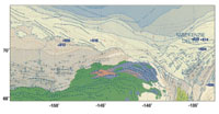
Tectonic Settings The following descriptions summarize the authors’ rationale for their classification of the first seven of the 20 areas where giants are concentrated. North Slope of Alaska and McKenzie delta. The deformation that shaped rocks of the North Slope and Brooks Range began during the Middle Devonian to Early Mississippian Ellesmerian orogeny. This event was followed by Early Cretaceous rifting, which led to formation of oceanic crust in the Canada basin and formation of a rifted, passive margin along the North Slope, Fig. 3. Early Cretaceous to recent sedimentation has been controlled by mainly clastic, passive-margin sedimentation, including deposition of the McKenzie delta with sources in the Brooks Range, located to the south. Sources, reservoirs and traps occur in the passive-margin section. For these reasons, the tectonic setting of the area’s seven giants is classified as a continental passive margin fronting a major ocean basin.
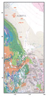
Rocky Mountain foreland. This foreland region, stretching from Mexico through Canada and central Alaska, resulted from eastward thrusting of a westward-thickening wedge of mostly shallow-water, platform-deposited sedimentary rocks of Precambrian through Jurassic age, Fig. 4. This occurred during Early Cretaceous through Eocene time. Major thrusts are oldest in the west and become progressively younger to the east. Dating of synorogenic, clastic deposits shows a complex pattern of thrust evolution. Giants are largely concentrated in complex basins of the Utah-Wyoming area and in western Canada’s asymmetrical foreland basin. The setting for these 18 giants is classified as a continental collision margin.
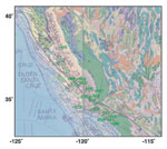
Southern California. Forearc structure is less prominent in the now strike-slip disrupted areas of coastal and Southern California, Fig. 5. Sources are Tertiary in age. Traps are mainly folds and faults related to Late Tertiary strike-slip faulting and shortening at the restraining bend of the fault in the Transverse Ranges. Southern California basins include thrust-bound "ramp basins" like the Ventura; complexly faulted, elongate basins like the Los Angeles; as well as more traditional pull-apart and fault-wedge, strike-slip basins. For these reasons, the tectonic setting of California’s 17 giants is classified as strike-slip.
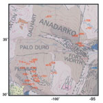
Permian and Anadarko basins. There are 26 giant fields in these basins, which are located in Texas and Oklahoma, Fig. 6. This area experienced a regional shortening during the Pennsylvanian-Permian collision between North America, northern South America and Africa. The intraplate deformation is, in some respects, analogous to the deformation of Asia in response to its Cenozoic collision with India. Deformation spread from east to southwest and accompanied the closure between the plates. Deformation in the Anadarko region reactivated an older rift feature at a high angle to the convergence direction and produced both thrust and strike-slip faulting. Deformation in the Permian basin produced a complex pattern of uplifts and basins that infilled with evaporites. Sources and reservoirs were mainly deepwater Paleozoic rocks deposited in basinal areas. For these reasons, the tectonic setting of this area is classified as a continental collisional margin.
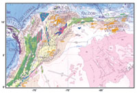
Gulf of Mexico. The Gulf resulted from Middle Jurassic rifting between North America, Mexico, the Yucatan Peninsula and northern South America, Fig. 7. Rifting resulted in passive margins flanking a small area of oceanic crust in the deep, central part of the basin. Structures on passive margins include growth faults, salt-withdrawal basins and salt domes that were produced by remobilization of Jurassic salt from sediment loading. For this reason, the area’s 42 giants are classified as a passive margin fronting a major ocean basin. Source rocks include Late Jurassic and Neogene marine shales. Jurassic evaporites provide effective seals for deeper offshore hydrocarbons related to the earlier rift history. These are now being tested by deepwater drilling.
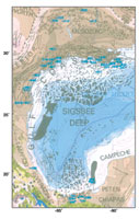
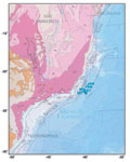
Northern South America. This area experienced Late Jurassic to Early Cretaceous rifting from southern North America and the Yucatan block, Fig. 8. This was followed by prolonged Cretaceous subsidence in a passive-margin setting. The passive-margin phase was interrupted by the west-to-east collision of the Caribbean arc with the passive margin during Paleocene-to-recent time.19 This event produced a thick foreland basin running the length of northern South America, which contains nearly all of the region’s 33 giant fields, including those in Maracaibo and Maturin basins. Source rocks include Late Cretaceous black shales deposited during sea-level highstands. Reservoirs include fractured carbonates and sandstones, and traps are mainly faults and folds produced during collision. For these reasons, giant fields in northern South America are classified as an arc / continental-collision margin.
Brazil. Still in the early phase of discovery, the area’s five giants occur in a limited part of the Campos basin (Fig. 9) that formed by early Cretaceous rifting from West Africa. Tectonic events included intense volcanic activity and rifting, with basins filled by alluvial, lacustrine and carbonate rocks. The end of the rifting phase was marked by formation of regional unconformity and initiation of passive-margin sedimentation. Production comes from the overlying passive-margin section, but source-rock studies indicate sources lie within Barremian-Aptian lacustrine shales deposited in underlying rifts. Reservoirs include Tertiary deepwater sandstones deposited in a passive margin setting. The authors classify this setting as a passive margin fronting a major ocean basin.
Conclusions After reclassification of 592 giant oil fields into six basin and tectonic-setting categories, several conclusions were reached, as noted below. (For basins with complex histories of repeated subsidence and inversion, the authors tried to identify the single basin phase most closely tied to formation of source rock and/or structural trap of the giant oil field.)
Previous correlation of 509 giant fields by Carmalt, et al., used basin classifications by Klemme, and Bally and Snelson. Using Klemme’s classification scheme, the three most common basins containing giant oil fields are: collision zones (40%); accreted margins (16%); and rifted margins (15%). Using the Bally and Snelson classification, the three most common basins containing giant oil fields are: type-A foredeeps (41%); cratonic basins (23%); and Atlantic-type passive margins (15%). Variations between the authors’ results and those of Carmalt, et al., probably reflect differing interpretations of the "main" basinal phase responsible for formation of source rocks, structures and stratigraphy of the giant field. This study found that rifting was the dominant process forming giant fields more often than previous studies found – despite the presence of later, superimposed convergent or strike-slip tectonics. Editor’s note: The authors’
biographies will appear in Part 2 of this article. Literature Cited 1 Klett, T., and J. Schmoker, "Changes in observed field-size estimates of the world’s giant oil fields," Abstracts, p. A106, AAPG Annual Convention, Denver, Colorado, June 3 – 6, 2001. 2 Halbouty, M., "Giant oil and gas fields of the decade 1990 – 2000," Online published version http://www.searchanddiscovery.com /documents. AAPG Annual Convention, Denver, Colorado, June 3 – 6, 2001. 3 Carmalt, S. W., and B. St. John, "Giant oil and gas fields," in M.T. Halbouty, ed., Future petroleum Provinces of the World, Memoir, 40, AAPG, Tulsa, Oklahoma, 1986. 4 Exxon Tectonic Map of the World, World Mapping Project, Exxon Production Research Company, Houston, Texas, 1985. 5 Pettingill, H. S., "Giant field discoveries of the 1990s," The Leading Edge, V. 20, No. 7, pp. 698 – 704, 2001. 6 Halbouty, M., et al., "World’s giant oil and gas fields, geologic factors affecting their formation, and basin classification [Part 1]," in M. Halbouty, ed., "Geology of giant petroleum fields," AAPG Memoir 14, pp. 502 – 528, 1970. 7 Halbouty, M., "Giant oil and gas fields of the decade 1968 – 1978," AAPG Memoir 30, p. 596, 1980. 8 Halbouty, M., "Giant oil and gas fields of the decade 1978 – 1988," AAPG Memoir 54, 1990. 9 Nehring, R., "Giant oil fields and world oil resources," Rand Corporation Report," R-2284-CIA, p. 162, 1978. 10 Klemme, H., "To find a giant, find the right basin," Oil and Gas Journal, Vol. 69, p. 103 – 110, 1971. 11 Klemme, H., "The giants and the supergiants," Oil and Gas Journal, Vol. 1, March 8 and 15, 1974. 12 Bally, A., and S. Snelson, "Facts and principles of world petroleum occurrence: Realms of subsidence," in A. Miall, ed., Facts and Principles of World Petroleum Occurrence, Canadian Society of Petroleum Geologists, Memoir 6, pp. 9 – 94, 1980. 13 Ivanhoe, L., and G. Leckie, "Global oil, gas fields tallied, analyzed," Oil and Gas Journal, Vol. 91, pp. 87 – 91, 1993. 14 Haeberle, F., "Giant oil fields in the United States by basin types," Abstract, AAPG Southwest Section meeting, Fort Worth, Texas, AAPG Bulletin, Vol. 77, p. 137, 1993. 15 Oliver, J., "Fluids expelled tectonically from orogenic belts: Their role in hydrocarbon migration and other geologic phenomena," Geology, Vol. 14, pp. 99 – 102, 1986. 16 Macedo, J., and S. Marshak, "Controls on the geometry of fold-thrust belt salients," Geological Society of America Bulletin, Vol. 111, pp. 1808 – 1822, 1999. 17 British Petroleum, Map of world total oil and gas reserves, American Association of Petroleum Geologists, Tulsa, 1992. 18 Pierce, W., "Southern Arabian basin oil habitat: Seals and gathering areas," Society of Petroleum Engineers, SPE25606, Bahrain Oil Show, pp. 103 – 111, 1993. 19 Pindell, J., R. Higgs, and J. Dewey, "Cenozoic palinspastic reconstruction, paleogeographic evolution, and hydrocarbon setting of the northern margin of South America," in Paleogeographic evolution and non-glacial eustasy, northern South America, SEPM Special Publication, No. 58, pp. 45 – 85, 1998. |
|||||||||||||||||||||||||||||||||||||||||||||||||||||||||||||||||||||||||||||||||||||||||||||||||||||||||||||||||||||||||||||||||||||||||||||||||||||||||||||||||||||||||||||||||||||||||||||||||||||||||||||||||||||||||||||||||||||||||||||||||||||||||||||||||||||||||||||||||||||||||||||||||||||||||||||||||||||||||||||||||||||||||||||||||||||||||||||||||||||||||||||||||||||||||||||||||||||||||||||||||||||||||||||||||||||||||||||||||||||||||||||||||||||||||||||||||||||||||||||||||||||||||||||||||||||||||||||||||||||||||||||||||||||||||||||||||||||||||||||||||||||||||||||||||||||||||||||||||||||||||||||||||||||||||||||||||||||||||||||||||||||||||||||||||||||||||||||||||||||||||||||||||||||||||||||
- Applying ultra-deep LWD resistivity technology successfully in a SAGD operation (May 2019)
- Adoption of wireless intelligent completions advances (May 2019)
- Majors double down as takeaway crunch eases (April 2019)
- What’s new in well logging and formation evaluation (April 2019)
- Qualification of a 20,000-psi subsea BOP: A collaborative approach (February 2019)
- ConocoPhillips’ Greg Leveille sees rapid trajectory of technical advancement continuing (February 2019)

