|
Sept.
2001 Vol. 222 No. 9
Feature Article
|
NATURAL GAS:
Part 6:
Anomalously pressured zones
Anomalously pressured gas accumulations in Rocky Mountain Laramide basins
Case history describes
application of new exploration / exploitation approach in area with non-conventional geology
Ronald C. Surdam, President, Innovative
Discovery Technologies, LLC, Laramie, Wyoming
 he
following discussion provides a definition and background of anomalously pressured (AP) reservoirs and the
vast potential of this underdeveloped resource. Challenges facing engineers in drilling and completing wells
safely and efficiently are outlined. And a new, innovative exploration / exploitation approach developed by
Innovative Discovery Technologies, LLC (IDT), of Laramie, Wyoming – a new Gas Technology Institute
subsidiary, created in partnership with Surdam Consulting, Inc. – is introduced and illustrated with a
case history application. The application is an example of the type of detailed information required to "intelligently"
develop AP gas assets. he
following discussion provides a definition and background of anomalously pressured (AP) reservoirs and the
vast potential of this underdeveloped resource. Challenges facing engineers in drilling and completing wells
safely and efficiently are outlined. And a new, innovative exploration / exploitation approach developed by
Innovative Discovery Technologies, LLC (IDT), of Laramie, Wyoming – a new Gas Technology Institute
subsidiary, created in partnership with Surdam Consulting, Inc. – is introduced and illustrated with a
case history application. The application is an example of the type of detailed information required to "intelligently"
develop AP gas assets.
Introduction
Anomalously pressured gas accumulations in Rocky
Mountain Laramide basins represent a huge, yet underdeveloped energy resource. For example, in the Lower-48
states in recent years, only Wyoming has maintained a positive slope on its gas production curves, i.e., new
gas discoveries are outstripping reserve depletion. This positive slope in Wyoming has largely resulted from
discoveries / developments at Jonah and Cave Gulch fields, both giant, AP gas accumulations.
Of course, future development of coal-bed gas will also
enhance the positive slope on the state’s gas production curve. Thus, in Wyoming, it has been development
of "unconventional" gas resources that has reversed the highly undesirable, but all too real, energy
depletion curves plaguing domestic U.S. production.
So-called unconventional, basin-center, or deep-basin
gas accumulations all have one characteristic in common – anomalous pressure. Basins characterized by
relatively continuous burial tend to be predominantly overpressured, whereas basins characterized by more
complex burial histories that include episodes of uplift may be under- or overpressured; or they may contain
rock-fluid systems both under- and overpressured. The subject of this article is anomalously pressured gas
accumulations, i.e., rock-fluid systems in which the pressure plots off the hydrostatic gradient, regardless
of what pressure nomenclature or basin one uses.
The working hypothesis presented is as follows: the
quickest way to reverse the negative slope of domestic gas production curves is to more effectively and
efficiently exploit AP gas accumulations. The magnitude of the energy resource is sufficient. In the Wind
River basin of Wyoming alone ( 8,000 mi2), the USGS estimates that the in-place AP gas resource is
about 900 Tcf; yet cumulative production from the stratigraphic units containing this resource, to date, has
been less than 1 Tcf. Thus, the energy resource is in place, but in most cases, lack of essential new
exploration / exploitation technologies and techniques has constrained development.
AP gas accumulations offer exploration scientists /
engineers a special set of challenges. If these challenges are met and overcome, essential new technologies
will be created and evolve, resulting in ever-increasing conversion of these resources to energy reserves.
Some, but not all of these challenges are discussed below.
Converting AP gas accumulations to viable energy
reserves has been a particularly expensive task for explorationists in general. Initial efforts to exploit
these resources have been disappointing and very costly, largely because traditional exploration and
completion techniques have proven to be relatively ineffectual. Conventional exploration techniques fail
because AP gas accumulations are not necessarily confined to structural or stratigraphic traps.
Jonah field provides an excellent illustration of this
point. Isopach and structural contour maps of the field1 clearly show that neither structural
closure nor stratigraphic pinch out characterizes Jonah, although faults form a "structural trap" as
lateral seals to the field. Not only is structural closure absent, there is no apparent indicator of the field
on 2-D seismic amplitude stack profiles across the field.1 Both the west- and south-bounding
faults (two of the field boundaries) are extremely difficult to discern on the seismic stack. Thus, Jonah
presents and illustrates the problems facing explorationists when searching for AP gas assets.
Another problem that is particularly vexing to
explorationists is that many anomalously pressured gas accumulations occur structurally down dip from water.
In other words, the AP accumulations occur
below the conventional water leg in many basins and may be part of a gas-charged column many thousands
of feet high. In these cases, the rock-fluid systems are compartmentalized, with the upper, conventional
fluid-flow system separated from the underlying, AP fluid-flow system by a regional pressure surface boundary.2
The most important task in resolving these problems is
to reduce uncertainty about the distribution of AP gas within the basin. Once gas distribution is determined,
the next significant step is to detect and delineate porosity / permeability sweet spots (areas of enhanced
storage capacity and deliverability) below the regional pressure surface boundary.2
Drilling
The challenges facing engineers designing drilling
strategies for anomalously pressured gas accumulations are equally daunting. Not only are there obvious safety
concerns when drilling across the regional pressure surface boundary into an AP fluid system, but the
characteristics of such a rock-fluid system can change abruptly and dramatically. The most significant change
occurs from a single-phase fluid flow system, e.g., dominantly water, typically under strong water drive, to a
multiphase fluid-flow system, dominated by capillarity.
This transition is accompanied by a pressure change
from normal to abnormal pressure, which is often abrupt. Moreover, the change can be from normal, i.e.,
hydrostatic, to significant overpressure or underpressure. The driller must design a strategy that
takes safety issues into account when moving from normal to anomalous pressure regimes – but that still
minimizes formation damage. Whether one drills into under- or overpressured, capillarity-dominated fluid
systems, the rock-fluid system is extremely sensitive to introduced fluids and, hence, mud weights. Ideally,
the drilling design should include an attempt to safely drill with an undercompensated mud program, and with
fluids compatible with the penetrated capillarity system – a monumental problem.
Completion
Completing wells in anomalously pressured terrains
presents equally perplexing problems. In many cases, the first step in completion is to mediate formation
damage acquired during drilling. Experience has demonstrated, particularly with respect to "tight gas
sands," that introduced water must be avoided during completion techniques. Also, remnant water in the
reservoir sequence must be avoided during fracture completions.
Excessive water production is a sure way to kill an AP
gas well. Extreme care must be taken to avoid fracing into AP domains characterized by significant volumes of
remnant connate water. Because AP gas accumulations are highly compartmentalized, limited-entry fracs and
water avoidance are highly desirable.
Innovative Exploration and Exploitation Approach
A new exploration / exploitation technology has been
developed that overcomes many challenges in searching for AP gas assets. The IDT technology, developed by
Surdam and Associates, significantly and quantifiably reduces the risk of exploiting gas assets in
low-permeability formations. Application of the IDT technology provides the operator, prior to drilling,
with the following essential information: 1) spatial distribution of gas-charged rock / fluid systems,
including pressure compartment boundaries; 2) location and nature of the regional pressure surface boundary,
or boundary between normally and anomalously pressured fluid systems (either under- or overpressured); 3)
determination of gas and water content in the fluid; 4) identification / spatial distribution of microfracture
swarms; and 5) orientation and timing of faults.
Only with such specialized information will optimum
drilling and completion practices be designed / employed that enable operators to avoid a multitude of
disastrous pitfalls currently associated with exploration in AP, low-permeability formations, such as
excessive water production, formation damage, and a wide range of problems associated with capillarity and "incompatible"
fluids. These problems, heretofore, have inhibited corporate enthusiasm by limiting profitability.
The new technology has been rigorously tested and
validated with both public data (Riverton Dome DOE Demonstration) and proprietary data (Jonah field), and in
28 other basins around the world. Armed with the technology, explorationists and engineers are able to more
effectively and efficiently detect / delineate commercial production sweet spots in low-permeability
formations, and avoid excessive water production by designing optimum drilling / completion programs, thereby
greatly increasing gas production from low-permeability formations.
Case History
To illustrate in more detail how the IDT technology
operates, consider the following case history for an AP gas accumulation. This case history is from an area
where there is a total lack of structural closure and no stratigraphic pinch outs with respect to the targeted
reservoir interval. Several nearby sonic logs from unsuccessful wells indicate that the targeted reservoir
interval in the area of interest is overpressured and relatively tight. The anomalous velocity volume shows
that a significant velocity anomaly, i.e., velocity slowdown, occurs at the level of the potential reservoir
interval, Fig. 1.
 |
|
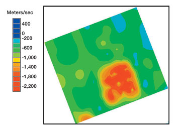
Fig. 1. Gas distribution. Anomalous
velocity map sliced at depth of reservoir interval of interest. Red area is characterized by anomalous
velocity values falling 1,600 to 2,000 meter/sec below (or slower) than would be predicted by typical
regional velocity / depth gradient at this depth. Intensely slow domains are the result of presence of
a significant ubiquitous free gas phase in the fluid. |
|
In addition, it is apparent from an anomalous velocity
cross-section through the area that a water-charged section exists in the formation directly beneath the
gas-charged sweet spot, Fig. 2. The most intense portion of the velocity anomaly within the targeted reservoir
falls nearly 2,000 m/s below the normal regional velocity / depth gradient at the depth of the target, Fig. 1;
thus, the rock / fluid volume of interest is characterized by intensely slow velocities, i.e., the interval
has a very high probability of being gas-charged.2
 |
|
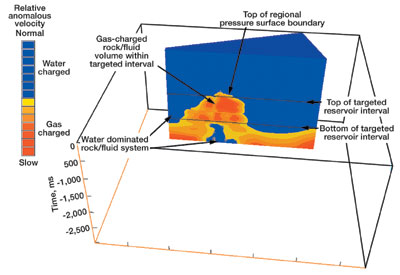
Fig. 2. Anomalous velocity
cross-section through the area shown in map view in Fig. 1. Note relief on regional velocity inversion
surface (or regional pressure surface boundary). Most important, the cross-section shows water-rich
domains above and below gas-charged rock / fluid system. |
|
The anomalous velocity volume also shows that there is
a very significant topographic high on the regional velocity inversion surface, Fig. 2. This topographic high
represents a gas chimney where gas is moving up into the stratigraphic section along a significant migration
conduit. At the level of the targeted reservoir interval, there are intense, non-oriented trace-to-trace
discontinuities, which, in this case, are interpreted to be fracture swarms. It is important to note that
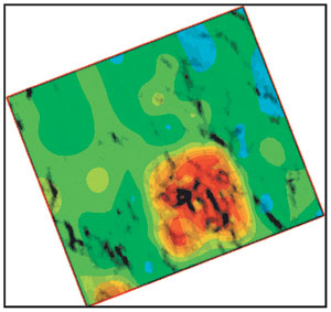
there is an impressive overlap between the anomalous velocities, Fig. 1, and the trace-to-trace discontinuity
anomalies, Fig. 3. This overlap likely represents an area or volume characterized by gas-filled (as indicated
by the anomalous velocities) fracture swarms (as indicated by the trace-to-trace discontinuities).
 |
|
Fig. 3. Gas distribution and
microfracture swarm distribution. Superposed anomalous velocity and trace-to-trace discontinuity maps
at level of targeted reservoir interval. Overlap of intensely slow velocities with intense
discontinuities is likely attributable to a gas-charged fracture swarm. |
|
The overlap of these key elements strongly suggests
that: 1) significant amounts of gas are present at the targeted-interval depth, e.g., tight gas sand; 2)
enhanced porosity / permeability is present in the form of fracture swarms; and 3) gas content of fluid within
the reservoir interval is relatively high in the area of interest. The "spider" diagram, i.e.,
inventory of all linear faults with lengths greater than 1,000 ft, constructed for the targeted reservoir
interval, shows that there are numerous linear faults and fault intersections in the area. This finding
supports the earlier conclusion that fracture swarms characterize the area, particularly in the vicinity of
the most intense velocity anomaly.
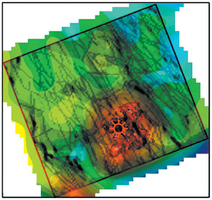
When superimposed, all of these key interpretive
elements, see table, overlap significantly within the targeted reservoir interval in the area of interest,
Fig. 4. Within the interpretive element overlap area, the probability of finding commercial anomalously
pressured gas assets in zones of enhanced porosity and permeability (production sweet spots) is extremely
high.
 |
|
Fig. 4. Superimposed positive critical
exploration elements: gas migration conduits, gas distribution, reservoir gas content, microfracture
swarm distribution and linear fault orientation. Overlap of these elements is interpreted as a
gas-charged domain with intense microfracture swarms. Well symbol shows location of a successful gas
well producing from low-permeability, "tight" gas sandstones. |
|
Key interpretive elements for sweet-spot
delineation
- Gas distribution (GD)
- Gas migration conduits (GMC)
- Microfracture swarm distribution (MSD)
- Reservoir gas content (RGC)
- Linear fault orientation (LFO)
- Reservoir characterization at-tributes (RCA)
The final success of a particular well in this area,
however, is predicated on avoiding water-dominated fluid systems that occur just below and adjacent to the
gas-charged sweet spot, Fig. 2, and on designing a careful drilling / completion program based on
well-conceived mud and frac programs that avoid fluid incompatibilities and formation damage. In this case
study, drilling occurred within the interpretive element overlap zone (Ven Diagram). Water-dominated fluid
systems both below and adjacent to the sweet spot were avoided; and the drilling / stimulation program
minimized formation / fluid damage, all of which resulted in a successful well.
This case study is a neat example of the type of
detailed information required to intelligently develop anomalously pressured gas assets. First, the gas
accumulation must be identified and delineated; next, production sweet spots must be described in detail and a
careful drilling / completion program must be designed based on this description; and, finally, problems such
as excessive water production, formation damage and fluid incompatibilities must be avoided. If any of these
steps are omitted, exploration uncertainty and subsequent risk increase dramatically. The IDT technology
allows operators to accomplish these steps and their ultimate goal – a successful exploration and
exploitation program for anomalously pressured gas resources. 
Acknowledgment
Special acknowledgment goes to GRI (GTI) and DOE for
providing financial support to allow the development of concepts for exploring anomalously pressured gas
accumulations in the Rocky Mountain Laramide basins. Dynamic Graphic EarthvisionTM software was
used in the geospatial modeling and visualizations presented in this article. ProMax seismic processing and
Landmark seismic interpretation software also were used in this project.
Literature
Cited
1 Surdam, R. C., J. Robinson, Z. S. Jiao
and N. K. Boyd, "Delineation of Jonah field using seismic and sonic velocity interpretations," in D.
Anderson, J. Robinson, J. Estes-Jackson and E. Coalson, Eds., Gas in the Rockies: Rocky Mountain
Association of Geologists, 2001, pp. 189 – 209.
2 Surdam, R. C., "A new paradigm for
gas exploration in anomalously pressured ‘tight gas sands’ in the Rocky Mountain Laramide basins,"
in R. C. Surdam ed., Seals, traps and the petroleum system: American Association of Petroleum
Geologists, Tulsa, Oklahoma, Memoir 67, 1997, pp. 283 – 298.

The author
|
 |
Ronald C. Surdam,
president, Innovative Discoveries Technologies, LLC., Laramie, Wyoming, earned AB and PhD degrees from the
University of California in 1961 and 1967. From 1966 to 1998, he served as assistant professor and
professor of geology at the University of Wyoming. From 1993 to1998, he was director of the Institute for
Energy Research, and from 1997 to 1998, the Enhanced Oil Recovery Institute. Before assuming his present
position in 2000, he was a professor emeritus and consultant to the University of Wyoming. Dr. Surdam has
pursued numerous professional activities, including: GSA, AAPG, SEPM, Sigma Xi, Wyoming Geological Assoc.
and SPE. He has received several professional awards and been a distinguished lecturer for several
organizations; and he has contributed more than 180 publications. |
| |
|
|
 |
Part 1:
Exploration Methods |
|
Part 2: North
America Outlook |
|
Part 3: HP/HT
Drilling and Completions |
|
Part 4: Tight
Formation Stimulation |
|
Part 5: Sour
Gas Handling |
|
Part 7:
Gathering and Compression |
|
Part 8:
Monetizing Stranded Gas |
|
|
|

