Nov. 2001 Vol. 222 No. 11
Feature Article
|
EXPLORATION
Tectonic setting of the world’s giant oil fields
Part 3 – A new classification scheme of the world’s giant fields reveals the regional geology where explorationists may be most likely to find future giants. In this, the last of a three-part series, six areas where giant fields are clustered are examined
Paul Mann and Lisa Gahagan, Institute for Geophysics, University of Texas at Austin; and Mark B. Gordon, GX Technology
 lthough there are large variations in reserve estimates, giant fields contain at least 65% of the world’s proven reserves.1 Therefore, knowledge of their tectonic setting, geologic history and conditions for hydrocarbon formation will contribute greatly to understanding the origin and future supply of the world’s hydrocarbons. Six areas ranging from Siberia to the Asia-Pacific where giant fields are densely clustered are presented. The authors discuss how the tectonics of these particular areas produced these clusters and their rationale for classification. lthough there are large variations in reserve estimates, giant fields contain at least 65% of the world’s proven reserves.1 Therefore, knowledge of their tectonic setting, geologic history and conditions for hydrocarbon formation will contribute greatly to understanding the origin and future supply of the world’s hydrocarbons. Six areas ranging from Siberia to the Asia-Pacific where giant fields are densely clustered are presented. The authors discuss how the tectonics of these particular areas produced these clusters and their rationale for classification.
Introduction
A "giant" oil field is defined as one containing proved reserves exceeding 500 million bbl; a giant gas field contains proved reserves of greater than 3 Tcf.2 "Reserves" refer to the ultimate recoverable amount and include the amount produced to date. Some fields are giants only when viewed on a boe basis.3
North American giant fields (without field outlines) were digitized from Carmalt and St. John’s published compilation.3 Field locations and outlines are derived from the Petroconsultants SA, digital database for non-North American giant fields (used with permission). The 592 giant fields of the world cluster in 20 regions (see Part 1). Detailed geologic maps of these regions are modified from the Exxon Tectonic Map of the World.4
| |
Legend for the twenty geological maps
For details, see complete legend in Exxon Tectonic Map of the World4
Capital letters: Basin and sub-basin names.
Outcrops: Color coded by age.
Light to moderate blue: Offshore areas.
Light to moderate brown: Total thickness (isopachs in km) of Phanerozoic sediment in basins and platforms.
Shades of purple: Upper Precambrian to Mississippian.
Blue: Pennsylvanian to Lower Triassic.
Shades of green: Middle Triassic to Oligocene.
Yellow: Miocene to recent. Structures indicated by standard map symbols.
|
|
| |
 |
| |
| |
Legend for giant fields
Colors refer to color-coding of the author’s geologic classification scheme of giants, and are the color of the location number and field on the 20 regional maps.
Light blue: Continental passive margins fronting major ocean basins. This category is reserved for giants which are clearly confined to non-rift controlled, passive-margin sections. It is difficult to rule out the importance of rifts and rift-localized steer’s head basins in passive-margin tectonic settings, because the level of rifting can become so deeply buried in passive-margin settings that it is difficult to resolve seismically or reach by drilling.
Blue: Continental rifts and overlying steer’s head sag basins. Rifts and the overlying, generally marine, sag basin are key for localizing and forming source rocks in poorly-circulated marine straits and lakes during the early stages of continental rifting – e. g., Late Jurassic-Early Cretaceous source rocks of Gulf of Mexico, Fig. 7, and Jurassic source rocks of West Africa, (in Part 2). Such rifts are either: aborted to form isolated intracontinental rifts surrounded by continental areas like the North Sea or West Siberian basin, (Part 2); or extended to form passive margins flanking major ocean basins such as the West African coast. These rifts typically become deeply buried beneath a carbonate, evaporitic and/or clastic passive-margin section.
Red: Continental collision margins. These margins produce deep, short-lived basins in interior areas but broad, wedge-shaped foreland basins in more external parts of the deformed belt where most giants are found. A popular model in the late 1980s was the "squeegee" model for expulsion of oil from source rocks shortened and buried in the more interior parts of the deformed belt.15
Macedo and Marshak16 proposed, on the basis of their inspection of the Map of World Total Oil and Gas Reserves,17 that there is a spatial correlation between location of foreland-basin oil fields and fold-thrust belt salients, or places where the fold-thrust belt protrudes or is convex to the foreland. Salient examples associated with oil fields include Alberta, Wyoming, Santa Cruz (Bolivia), Verkhoyansk (Siberia), northern Carpathians (Europe), Taiwan, Zagros and Apennines (Italy). In all cases, the greatest concentration of oil and gas fields is opposite the apex of the salient.
To explain the spatial association, they speculate that:
- thicker, basinal-sedimentary rocks present at salients are more likely to yield greater volumes of source and reservoir rocks;
- thicker basinal rocks also produce more fold culminations, which are likely to act as structural traps; and
- slight along-strike extension at apex areas could result in increased fracturing that could provide the vertical permeability to permit migration of oil and gas in association with basinal brines. In contrast to the above concepts, explorationists in foreland areas like the Persian Gulf have noted that horizontal migration is small, convergent deformation effects are minimal, and most migration is vertical above deep-seated source rocks in the rift or passive-margin section.18
Orange: Arc-continental collision margins. Foreland basins in these settings can sometimes be more narrow and contain thinner stratigraphic fill than in continent-continent collisional settings, because island arcs lack the size, crustal thickness and deformation effect of a colliding continent. For example, many of the circum-Caribbean forelands are narrow for the above reasons and as a result of the oblique angle of collision between the Caribbean-arc and the continents of North and South American.19
Green: Strike-slip margins. Strike-slip basins are relatively few in comparison to more common rift, passive margin and collisional basin types. In general, strike-slip margins form during the later stages of continental or arc collision as in Anatolia today, or during a ridge-subduction event along a subduction boundary, as in California. Despite their generally small areal extent relative to foreland and rift basins, strike-slip basins can contain extremely thick sedimentary sequences, including excellent source rocks formed during early basinal history. The inherent complexity of strike-slip boundaries with lateral offsets and structural overprinting probably makes it too difficult to achieve the ideal combination of source-reservoir and trap needed to make giant fields.
Purple: Subduction margins. These margins are the least productive for giant fields due to low porosity and clay-rich sediments common in arc environments. Subduction margins in tropical areas such as those in southeast Asia can contain carbonate traps.
|
|
| |
|
|
Tectonic Settings
The following descriptions summarize the authors’ rationale for their classification of six areas where giants are concentrated.
Sunda. The 26 giant fields in Sunda occur in three main areas, Fig. 1. These are: 1) central and northern Sumatra, 2) Brunei on the western margin of Borneo, and 3) the Pattani trough, offshore Thailand. In Sumatra, inverted Late Neogene rift structures on continental collision are present in a backarc setting and were classified as a continental collision zone. The Borneo area was classified as an arc-continent collision zone, and the Pattani trough as a pull-apart basin on a strike-slip fault.
| |
Sunda |
|
| |
228 |
Yadana, Myanmar, Gas (Andaman) |
|
| |
229 |
Bach Ho, Vietnam, Oil/gas (Mekong) |
|
| |
230 |
Bongkot, Thailand, Gas/cnd/oil (Malay) |
|
| |
231 |
Guntong, Malaysia, Oil/gas (Malay) |
|
| |
232 |
Seligi, Malaysia, Oil/gas (Malay) |
|
| |
233 |
F6, Malaysia, Gas/cnd/oil (Sarawak-Zengmu) |
|
| |
234 |
E11, Malaysia, Gas/cnd (Sarawak-Zengmu) |
|
| |
235 |
F23, Malaysia, Gas/cnd (Sarawak-Zengmu) |
|
| |
236 – 7 |
Champion, Brunei, Oil/gas/cnd (Sabah) |
|
| |
238 – 9 |
Ampa Southwest, Brunei, Oil/gas (Sabah) |
|
| |
240 – 1 |
Seria, Brunei, Oil/gas (Sabah) |
|
| |
242 |
Duri, Indonesia, Oil (Central Sumatra) |
|
| |
243 |
Minas, Indonesia, Oil/gas (Central Sumatra) |
|
| |
244 |
Bangko, Indonesia, Oil (Central Sumatra) |
|
| |
245 |
Arun, Indonesia, Gas/cnd (N. Sumatra) |
|
| |
246 |
Badak, Indonesia, Gas/cnd/oil (Kutei) |
|
| |
247 |
Arjuna B, Indonesia, Oil/gas/cnd (NW Java) |
|
| |
248 – 9 |
Attaka, Indonesia, Oil/gas/cnd (Kutei) |
|
| |
250 |
Natuna, Indonesia, Gas (Sarawak-Zengmu) |
|
| |
251 |
Tunu, Indonesia, Gas/cnd/oil (Kutei) |
|
| |
252 |
Handil, Indonesia, Oil/gas (Kutei) |
|
| |
253 |
Nilam (Kalimantan), Indonesia, Gas/cnd/oil (Kutei) |
|
| |
303 |
Yacheng 13-1, China, Gas/cnd (Song Hong-Yinggehai) |
|
| |
310 |
Peciko Barat-laut, Indonesia, Gas/cnd (Kutei) |
|
| |
311 |
Malampaya 1, Philippines, Gas/cnd/oil (N. Palawan) |
|
| |
312 |
Dongfang 1-1, China, Gas (Song Hong-Yinggehai) |
|
|
|
|
 |
|
West Siberian basin. The area’s 66 giants (Fig. 2) formed in a northward-plunging Jurassic-Quaternary sag basin overlying a Permo-Triassic rift system. Such rifts are aborted to form isolated intracontinental rifts that are surrounded by continental areas. Reservoirs lie in Cretaceous sag fill. Source rocks include both Cretaceous and Upper Jurassic shales.5
| |
West Siberia |
|
| |
393 |
Ust-Balyk-Mamontovo, Russia, Oil/gas (West Siberian) |
|
| |
394 |
Lokosovo, Russia, Oil/gas (West Siberian) |
|
| |
395 – 6 |
Pravdinsk-Salym, Russia, Oil/gas (West Siberian) |
|
| |
397 |
Taylakovskoye, Russia, Oil/gas (West Siberian) |
|
| |
398 |
Srednebalyk, Russia, Oil/gas (West Siberian) |
|
| |
399 |
Agan, Russia, Oil/gas (West Siberian) |
|
| |
400 |
Malobalyk, Russia, Oil/gas |
|
| |
402 |
Pokachevsko-Ur’yevskoye, Russia, Oil/gas (West Siberian) |
|
| |
403 |
Tevlin-Konitlor, Russia, Oil/gas (West Siberian) |
|
| |
405 |
Var’yegan Severnyy, Russia, Oil/gas (West Siberian) |
|
| |
406 |
Kholmogory, Russia, Oil/gas (West Siberian) |
|
| |
408 – 9 |
Yermakovo, Russia, Oil/gas (West Siberian) |
|
| |
410 |
Sutorminskoye, Russia, Oil/gas (West Siberian) |
|
| |
411 |
Tarasovskoye (W Siberia), Russia, Oil/gas/cnd (West Siberian) |
|
| |
412 – 3 |
Tagrinskoye, Russia, Oil/gas (West Siberian) |
|
| |
416 – 8 |
Yagun, Russia, Oil/gas (West Siberian) |
|
| |
419 |
Priobskoye, Russia, Oil/gas (West Siberian) |
|
| |
420 |
Pogranichnoye (Tyumen), Russia, Oil/gas (West Siberian) |
|
| |
421 – 2 |
Tyanovskoye, Russia, Oil/gas (West Siberian) |
|
| |
433 |
Bystrinskoye, Russia, Oil/gas/cnd (West Siberian) |
|
| |
434 |
Samotlor, Russia, Oil/gas/cnd (West Siberian) |
|
| |
435 |
Bol’shoy Gubkin, Russia, Gas/cnd/oil (West Siberian) |
|
| |
436 |
Russkoye, Russia, Oil/gas (West Siberian) |
|
| |
437 |
Vengayakha, Russia, Gas/oil |
|
| |
438 |
Vat’yegan, Russia, Oil/gas (West Siberian) |
|
| |
439 – 41 |
Povkhovskoye, Russia, Oil/gas (West Siberian) |
|
| |
446 |
Var’yegan, Russia, Oil/gas/cnd (West Siberian) |
|
| |
449 |
Fedorovo-Surgut, Russia, Oil/gas/cnd (West Siberian) |
|
| |
450 |
Van’yegan, Russia, Oil/gas/cnd (West Siberian) |
|
| |
454 |
Komsomol’skoye Russia, Gas/cnd/oil (West Siberian) |
|
| |
455 |
Medvezhye, Russia, Gas/cnd (West Siberian) |
|
| |
457 |
Russkoye Yuzhnoye, Russia, Gas/oil (West Siberian) |
|
| |
458 |
Yamsovey, Russia, Gas/cnd (West Siberian) |
|
| |
459 |
Urengoy Severnyy, Russia, Gas/cnd/oil (West Siberian) |
|
| |
460 |
Tarko-Sale Vostochnyy, Russia, Oil/gas/cn (West Siberian) |
|
| |
461 |
Yetypur, Russia, Gas/oi (West Siberian) |
|
| |
462 |
Bovanenko, Russia, Gas/cnd/oil (West Siberian) |
|
| |
464 |
Tarko-Sale Zapadnyy, Russia, Gas/cnd/oil (West Siberian) |
|
| |
466 |
Nakhodka, Russia, Gas/oil (West Siberian) |
|
| |
469 |
Bol’shoye Kruzenshtern, Russia, Gas/cnd (West Siberian) |
|
| |
470 |
Gydanskoye, Russia, Gas (West Siberian) |
|
| |
471 |
Antipayuta, Russia, Gas (West Siberian) |
|
| |
473 |
Novoportovskoye, Russia, Gas/oil (West Siberian) |
|
| |
474 |
Lyantor, Russia, Oil/gas/cnd (West Siberian) |
|
| |
476 |
Komsomol’skoye Severnoye, Russia, Oil/gas/cnd (West Siberian) |
|
| |
477 |
Vachim, Russia, Oil/gas (West Siberian) |
|
| |
478 |
Muravlenko, Russia, Oil/gas (West Siberian) |
|
| |
479 |
Kharampur, Russia, Oil/gas/cnd (West Siberian) |
|
| |
480 |
Verkhne-Kolik’yegan, Russia, Oil/gas/cnd (West Siberian) |
|
| |
484 |
Zapolyarnoye, Russia, Gas/cnd/oil (West Siberian) |
|
| |
487 |
Urengoy, Russia, Gas/cnd/oil (West Siberian) |
|
| |
490 |
Arkticheskoye, Russia, Gas/cnd/oil (West Siberian) |
|
| |
494 |
Yamburg, Russia, Gas/cnd/oil (West Siberian) |
|
| |
495 |
Yubileynoye (Tyumen), Russia, Gas/cnd/oil (West Siberian) |
|
| |
496 |
Pelyatkino, Russia, Gas/cnd (Yenisey) |
|
| |
498 |
Semakovskoye-Anderpayuta, Russia, Gas/cnd (West Siberian) |
|
| |
500 |
Urengoy Vostochnyy, Russia, Gas/cnd/oil (West Siberian) |
|
| |
508 |
Kharasavey, Russia, Gas/cnd (West Siberian) |
|
| |
513 |
Krasnoleninskoye, Russia, Oil/gas/cnd (West Siberian) |
|
| |
514 |
Sugmut, Russia, Oil/gas (West Siberian) |
|
| |
515 |
Vyngapur, Russia, Gas/cnd/oil (West Siberian) |
|
| |
516 – 7 |
Druzhnoye, Russia, Oil/gas (West Siberian) |
|
| |
518 |
Yaroyakha, Russia, Gas/cnd/oil (West Siberian) |
|
| |
519 |
Leningradskoye (Kara), Russia, Gas/cnd (Kara) |
|
| |
521 |
Rusanovskoye (Kara), Russia, Gas/cnd (Kara) |
|
| |
523 |
Salym Zapadnyy, Russia, Oil/gas (West Siberian) |
|
|
|
|
 |
|
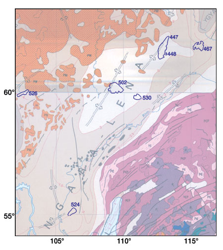
Siberia. Seven giant fields have been discovered in Precambrian-Cambrian sedimentary rocks in this underexplored region of the Siberian platform, Fig. 3.5 Reservoirs and sources comprise late Precambian-Cambrian clastic rocks and carbonate rocks, with seals provided by Cambrian evaporites. A rift setting for these fields was inferred.
| |
Siberia |
|
| |
447 |
Srednebotuoba, Russia, Gas/cnd/oil (Vilyuy) |
|
| |
448 |
Srednebotuoba, Russia, Gas/cnd/oil (Vilyuy) |
|
| |
467 |
Verkhne-Vilyuchanka, Russia, Gas/oil (Vilyuy) |
|
| |
502 |
Verkhne-Chona, Russia, Gas/cnd/oil (Angara) |
|
| |
524 |
Kovykta, Russia, Gas/cnd (Angara) |
|
| |
526 |
Soba (Sobinskoye), Russia, Gas/cnd/oil (Tunguska) |
|
| |
530 |
Talakan, Russia, Oil/gas/cnd (Angara) |
|
|
|
|
Northwest Australia. This margin rifted during the Middle Jurassic. The region’s five giant fields are mainly found in the overlying Upper Jurassic-to-recent passive margin section, which drapes earlier rift structures, Fig. 4. For this reason, the tectonic setting was classified as a passive margin fronting a major ocean basin.
| |
NW Austria |
|
| |
258 |
Rankin North, Australia, Gas/cnd (Carnovon) |
|
| |
259 |
Goodwyn, Australia, Gas/cnd/oil (Carnovon) |
|
| |
260 |
Scarborough 1, Australia, Gas (Carnovon) |
|
| |
261 |
Gorgon 1, Australia, Gas/cnd (Carnovon) |
|
| |
315 |
Bayu/Undan, Australia/Indonesia, Gas/cnd (Bonaparte) |
|
|
|
|
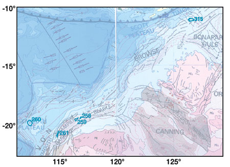 |
Fig. 4. Northwest Australia.
|
|
Bass Strait, Australia / Tasmania. The three giant fields in the Bass Strait area are underlain by the Gippsland rift basin (Fig. 5), which is the most prolific oil and gas province in Australia. Geologic development of Gippsland basin is marked by a protracted and multistage Early to Late Cretaceous rift history, including separation of Australia and Antarctica and the opening of oceans east and west of Australia. Sources and reservoirs occur in the late to post-rift sequence.6 Despite location of the giants above a failed east-west rift that extends westward from the Tasman Sea, this setting was classified as a continental passive margin fronting a major ocean basin.
| |
Bass Strait |
|
| |
255 |
Halibut-Cobia, Australia, Oil/gas/cnd (Gippsland) |
|
| |
256 |
Kingfish, Australia, Oil/gas/cnd (Gippsland) |
|
| |
257 |
Mackerel, Australia, Oil/gas/cnd (Gippsland) |
|
|
|
|
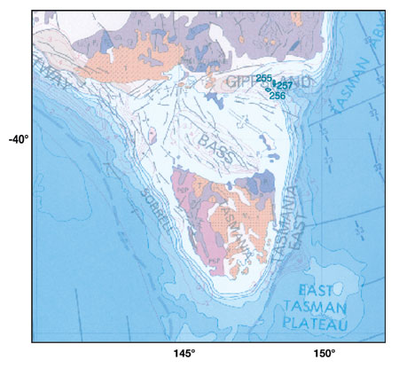 |
Fig. 5. Bass Strait, Australia / Tasmania.
|
|
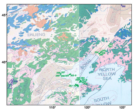
China. The 10 giant fields in eastern China occur mainly in Bohai basin (Fig. 6), one of a family of early Cenozoic extensional basins that lie along the eastern margin of Asia from Russia to Vietnam.7 Paleocene to early Eocene rifting was diffuse, trans-tensional, and related to rollback of the subducted Pacific plate beneath the Asian continent, while Middle Eocene rifting appears to have been more organized in a large, right-stepping basin that formed as a very large pull-apart basin on right-lateral strike-slip faults. Narrower trans-tension zones are present north and south of the basin. Earthquakes indicate that right-lateral strike-slip faulting continues to present-day. For this reason, this tectonic setting was classified as strike-slip. Reservoirs include carbonate karst units that are sourced by Paleogene shales. 
| |
China |
|
| |
264 – 6 |
Shuguang (Liaohe Complex), China, Oil (Bohai) |
|
| |
267 – 79 |
Shengtuo (Shengli Complex), China, Oil/gas (Bohai) |
|
| |
280 |
Huanxiling (Liaohe Complex), China, Oil (Bohai) |
|
| |
282 |
Saertu (Daqing Complex), China, Oil (Songliao) |
|
| |
284 |
Gudao (Shengli Complex), China, Oil/gas (Bohai) |
|
| |
285 – 88 |
Renqiu, China, Oil/gas (Bohai) |
|
| |
289 – 99 |
Gudong (Shengli Complex), China, Oil/gas (Bohai) |
|
| |
301 – 02 |
Shenyang (Liaohe Complex), China, Oil/gas (Bohai) |
|
| |
304 – 09 |
Dagang Complex, China, Oil/gas (Bohai) |
|
| |
316 |
Jingbian-Hengshan, China, Gas (Ordos) |
|
|
|
|
Literature Cited
1 Klett, T., and J. Schmoker, "Changes in observed field-size estimates of the world’s giant oil fields," Abstracts, p. A106, AAPG Annual Convention, Denver, Colorado, June 3 – 6, 2001.
2 Halbouty, M., "Giant oil and gas fields of the decade 1990-2000," Online published version http://www.searchanddiscovery.com /documents. AAPG Annual Convention, Denver, Colorado, June 3 – 6, 2001.
3 Carmalt, S. W., and B. St. John, "Giant oil and gas fields," in M.T. Halbouty, ed., Future petroleum Provinces of the World, Memoir 40, AAPG, Tulsa, Oklahoma, 1986.
4 Exxon Tectonic Map of the World, World Mapping Project, Exxon Production Research Company, Houston, Texas, 1985.
5 Tull, S., "The diversity of hydrocarbon habitat in Russia," Petroleum Geoscience, Vol. 3, pp. 315 – 325, 1997.
6 Glenton, P., "Snapper field, Australia: Offshore Gippsland basin, southeast Australia," in Structural Traps V, compiled by N. Foster and E. Beaumont, AAPG Treatise of Petroleum Geology, Atlas of Oil and Gas Fields, AAPG, Tulsa, OK, pp. 227 – 250, 1991.
7 Allen, M., et al., "Early Cenozoic two-phase extension and Late Cenozoic thermal subsidence and inversion of the Bohai basin, northern China," Marine and Petroleum Geology, Vol. 14, pp. 951 – -972, 1997.
The authors
|
 |
Paul Mann has worked at the University of Texas Institute for Geophysics since 1983 and is currently a senior research scientist there. He earned a PhD in geological sciences from the State University of New York at Albany. He has held visiting professorships in New Zealand and France. Mann has done geological / geophysical fieldwork throughout the Caribbean region, as well as participated on several research cruises offshore New Zealand and in the Western Pacific. He invites comments at: paulm@ig.utexas.edu.
|
|
Lisa Gahagan has been project manager for PLATES, a global plate tectonic research project at the Institute for Geophysics of the University of Texas at Austin, since its inception in 1991. She earned a master’s in geological sciences from the University of Texas at Austin.
|
|
Mark B. Gordon has done geological research in Central America, Cuba, France and Saudi Arabia as a post-doctoral scientist at Rice University and the University of Paris. He has been working at GX Technology since 1997 doing pre-stack depth seismic processing on basins throughout North America. He earned a PhD in geological sciences from the University of Texas at Austin.
|
| |
|
|