Sound technology and better regulation make field development economical
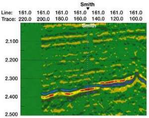
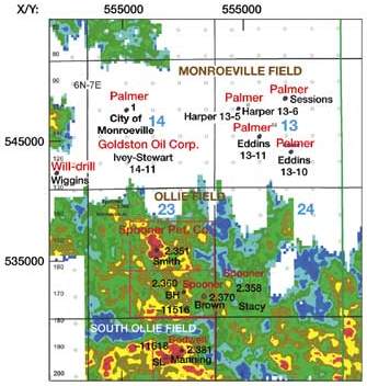
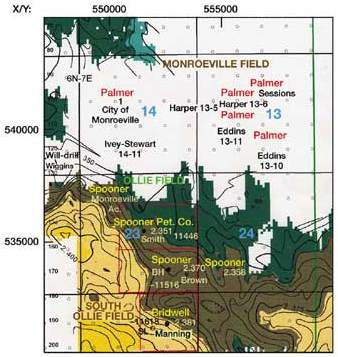
Sound technology and better regulation make field development economicalBrian Sims, Independent, Madison, Miss. Bottom line. Improved reservoir definition from 3-D seismic, combined with progressive regulation allowing reservoir-based spacing units, enabled Spooner Petroleum Co. to develop the Ollie field, a Norphlet play in southwest Alabama. Lower development costs with reservoir-based spacing units made field development economical. Horizontal lateral technology in the second development well allowed it to reach favorable reservoir development, precluding a potential dry hole. Frisco City sand background. In southwest Alabama, there have been a number of fields found associated with structure as a result of paleoknobs covered with the stratigraphy of the Jurassic rocks. Early wells were drilled in hopes of finding Smackover production on the crest and flanks of these knobs. When the 20-million-plus-bbl North Frisco City field was discovered in 1991, the area was ablaze with activity targeting the Haynesville-age Frisco City sand. As exploration settled down to a normal pace, yet another zone of interest came to light. In 1994, drilling on the flanks of one of these small paleoknob structures discovered North Excel field, which produced from Norphlet sands as they pinch out on the flanks. In 1996, South Ollie field became the second field in the trend to be completed as a Norphlet producer. Ollie field. The drilling and discovery of Ollie field, the third Norphlet field found in the trend, combined sound exploration science with progressive regulatory discretion. In the fall of 1994, Palmer Petroleum drilled their Sessions 1, which was the discovery well for Monroeville field in Monroe County, Alabama. This Frisco City sand discovery, which was drilled to a depth of 11,360 ft, was initially located based on 2-D seismic coverage. In order to optimize the development phase, a 3-D shoot was performed. The survey extended beyond the supposed prospect limits in order to identify other possible favorable structures or anomalies. As it turned out, an interesting amplitude anomaly appeared, located south and separate from Monroeville field, Fig. 1. The 3-D seismic, when integrated with existing well control, showed that the amplitude anomaly was in the Norphlet formation. A map plot (Fig. 2) of the data showed that this smaller amplitude anomaly was located such that it would normally require four, 160-acre drilling units to develop – way too much investment where the area of maximum amplitude only covers about 20 acres, Fig. 2.
Armed with high quality technical data, Spooner Petroleum approached the Alabama Oil and Gas Board Supervisor with a special request – 160-acre units that would fit the potential reservoir rather than sticking with traditional governmental section 160s. By presenting the 3-D picture, both operator and regulator could see the reasonableness of the request. The anomaly appears too small for drilling up to four wells, yet it could be drilled if one well would suffice. The board broke new ground by allowing the 160-acre unit to be configured based on evidence presented in the 3-D seismic analysis. Drilling results. Spooner Petroleum, as operator, located the Smith 1 on the best position of the Norphlet amplitude map, Fig. 2. The well was drilled to 12,041 ft and completed as the discovery well for Ollie field in the Norphlet formation, flowing 186 bopd and 432 Mcfgd on an 8/64-in. choke with FTP of 1,965 psi. As of February 2000, the well was producing 4,261 bbl per month and has produced 107,374 bbl of 54° API oil and 240,965 Mcfg. Prior to drilling, the exploration team felt that the good amplitude anomaly (shown in red in Figs. 1 and 2) was indicating the better porosity and permeability in the Norphlet sand. A second, 160-acre unit was formed south of Spooner’s Smith 1. Because this unit did not have an amplitude anomaly as good as the first well (Fig. 2), the location was picked on the basis of staying structurally as high as possible, Fig. 3.
The well, the Spooner Brown 1 (Meigs in official completion reports), was drilled to a vertical depth of 12,100 ft and cored the Norphlet. The core found tight Norphlet with a show of oil. After getting no recovery from a DST attempt, the decision was made to drill a horizontal lateral in the direction of more favorable amplitude, although it was not nearly as pronounced as that associated with the discovery well, Fig. 2. The 541-ft lateral in the Norphlet did reach better rocks. It was completed in September 1998. The official completion was reported as flowing 410 bopd and 840 Mcfd on a 24/64-in. choke, with 515 psi FTP and 49.5° oil. As of February 2000, this well was making 1,105 bbl of oil per month and had a cumulative production of 45,236 bbl of oil and 73,774 Mcfg. The reduced production performance is consistent with the idea that the amplitude anomaly reflects the better porosity and permeability. Sound science and good regulatory judgement made this discovery possible. As technology allows the industry to identify smaller, high-quality prospects, it will require progressive regulatory judgment, as exhibited here, to fully realize the potential from these smaller prospects. Acknowledgment Jack Moody of the Mississippi Office of Geology assisted greatly in compiling this case study. Thanks also go to Spooner Petroleum Co. for sharing information about their field experience. The authorBrian Sims is an independent geologist in the Jackson, Miss., area. He has 19 years of experience in oil and gas exploration, development and production, principally in the onshore Gulf Coast region. His prior experience includes working for Clayton W. Williams, Jr., Inc. Mr. Sims serves on PTTC’s board, representing its Eastern Gulf Region, and is a past president of the Mississippi Geological Society. He received a BS in geology from Millsaps College in Jackson. |
|||||||||||||||