New regional 3D framework delivers fresh insights into complex petroleum systems
In the past 20 years, two of the world’s largest offshore fields were discovered in the Campos and Santos basins along Brazil’s Atlantic coast within the pre-salt play. This area is informally known as “Picanha,” due to its similarity in shape to the prized cut of beef. ION initiated its Picanha Project to integrate all available 3D field data from more than 50 surveys, to be reprocessed and depth-imaged, using the latest technology. The aim is to improve geoscientists’ understanding of the pre-salt reservoir characterization, Fig. 1.
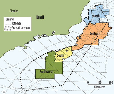
The project defines the next logical step in developing a regional geological framework. Grounded in the original 2D BrasilSPAN regional framework, Picanha provides high-resolution prospect-level evaluation data within a basin-wide context, which is essential to identifying geological features and reducing technical uncertainty. Together, the two projects provide the context and calibration for creating play-based exploration strategies across entire margins. The final deliverable is approximately 100,000 km2 of seamlessly integrated seismic, the largest dataset of its kind offshore Brazil. Each individual input survey ties in depth, having originated from a single macro-velocity model derived from the 2D surveys (Fig. 2), covering approximately 1,200,000 km2—roughly twice the landmass of Texas. The imaging depth is down to 15 km, and is limited only by the input data length.
This approach combines the strengths of regional 2D data, with newly imaged 3D information. The combination enables E&P companies to evaluate the complex basins and identify opportunities for upcoming licensing rounds. The regional perspective provides context to evaluate risk, and rank a portfolio of opportunities for current and future exploration needs.
TECHNOLOGICAL ADVANCES
The large 3D seismic imaging project integrates the company’s local geo-knowledge with new accelerated imaging, making it possible to rapidly deliver vast volumes of high-quality data. The workflow includes upgraded technology and local experience, in addition to a collaboration portal for client interaction, which increases productivity. The accelerated imaging workflow was first deployed in the Campeche reprocessing and reimaging effort across 20 existing 3D surveys that cover 82,000 km2 offshore Mexico.
To meet timelines for acreage block evaluation prior to licensing rounds, Picanha and Campeche delivered two intermediate volumes, in addition to a final set. The first product, known as Fast Track (FT), is designed to quickly image data to understand the geology, and to identify areas that may require further evaluation. The second volume, Enhanced Fast Track (EFT), is fully anisotropic and includes modeled salt bodies with multiple tomographic updates. These products were delivered prior to the lease sale dates, and provided the resolution for prospect and lead identification. The final interpretation product, called Full Flow (FF), contained multiple iterations and definition of salt bodies and extensive geological evaluation in the velocity model, down to the pre-salt section. This volume provides the resolution to evaluate prospect risk.
In the Campeche program, the first 20,000 km2 (VTI, velocity model) were delivered in six weeks. The northern EFT (42,000 km2) was delivered in three to five months. The enhanced evaluation started with field tapes, followed by complete velocity models with top and base salt interpretations, and 30-Hz RTM. A complete volume with updated seismic velocities and salt interpretation for velocity model-building was delivered, reducing turnaround time and improving imaging uplift.
Campeche and Picanha have both completed various phases of EFT, and are in the process of imaging the FF product. The following examples are from EFT products, but imaging will continue through the FF stage.
BRAZIL OPENS OFFSHORE MARKET
Brazil’s oil and gas sector is undergoing its greatest transformation since the founding of Petrobras in 1953. The country’s petroleum administrative agency, ANP, has created flexible terms for upcoming licensing rounds. Additionally, the 2010 pre-salt law was amended in November 2016, making the operatorship mandate optional, opening the door for foreign companies to act as operators under a production sharing contract (PSC) within the pre-salt area. Additional industry reforms were announced in April 2017 that reduced local content requirements and established a three-year timetable of license round activity — the first multi-year plan in a decade. Nine bidding rounds are planned for 2017–2019, giving many new E&P companies an opportunity to explore in Brazil.
Numerous pre- and post-salt play types are present within these basins. To date, exploration has been focused primarily on post-salt, or supra-salt, prospects. However, the giant Tupi discovery, known today as Lula, indicates the vast potential for pre-salt exploration targets. Combining the deeply imaged BasinSPAN products, with the reimaged Picanha 3D, enables interpreters to gain the detail needed in the pre- and post-salt sections by better defining the geometries and geophysical properties of these zones.
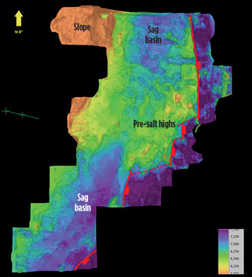
Due to the large volume of salt overlying the pre-salt sag basin, understanding the kinematics of salt tectonics is critical for prospect identification in the post-salt sequences (traps in reservoirs pinching out onto the salt) and in the underlying sag section (where imaging these geometries depends on the complex ray paths through the salt). Improved seismic imaging of the early Cretaceous pre-salt and sag sequences, using advancements in migration algorithms and velocity models that incorporate geologically-driven “geo-bodies” (shale structures, carbonates, anhydrites), helps identify reservoir and seal seismic facies, create additional play types, and improve understanding of the underlying basement.
As the pre-salt hydrocarbon potential is developed, mapping of sub-salt structural highs and paleogeographic features will enable explorers to further high-grade areas of each basin.
3D VERSUS 2D DATA
The BasinSPAN programs are used to develop the basin-wide structural and stratigraphic frameworks, providing operators a greater understanding of which part of a basin may be prospective and fit their portfolio strategy. In areas where dense 2D seismic grids and older 3D volumes are available, the question is which program is the most effective? Typically, licensing 3D data is more expensive than 2D. However, when 3D multi-client data is in the public domain, reimaging this data is more economical and has greater value in making investment decisions than purchasing 2D data.
Both the Picanha and Campeche 3D projects were designed as cost-effective tools for oil companies to gain understanding and access new areas. However, 3D still has an advantage over 2D data, because it’s more detailed, so a higher-resolution interpretation is possible. This reduces interpretation uncertainties during trap definition, migration pathways, seal integrity and while analyzing direct hydrocarbon indicators (DHIs).
Salt structures pose challenges for seismic velocity models. Salt is a common denominator in the Campeche and Picanha projects. As such, it is important to understand the shape and evolution of salt bodies to develop play concepts unique to each basin. In the Santos and Campos basins of Brazil, the pre-salt section is the newest area of interest. It is a logical next phase in exploration, given the success of the supra-salt section.
In Mexico, the entire stratigraphic section is new to the industry, as Pemex had been the sole player prior to the reform. An abundance of Mexico’s oil production has come from marine carbonates in the deeper Cretaceous and Jurassic sections. Most of the new companies in the area are pursuing opportunities in shallower clastic supra-salt sections. Unlike Brazil, the pre-salt section has not been tested in the Mexican sector of the Gulf of Mexico.
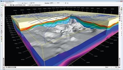
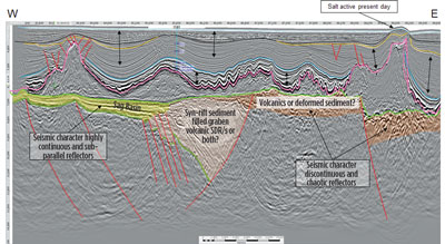
Why are 3D data necessary to define risk elements in Brazil and Mexico? The primary reason is that 2D data do not capture the detail required for defining salt body geometry or DHI analysis. Trapping geometries around, or under, salt or geo-bodies that have a different velocity than the surrounding sediment is dependent on the quality and accuracy of the image, and shape of that body. DHIs, such as amplitude versus offset (AVO), flat spots and down-dip amplitude conformance, all require data from different angles and azimuths that are only captured by 3D data. The recent Zama-1 discovery is an excellent example of where ION reimaging helped identify this prospect. The same will be true in the pre-salt section of Brazil, where the stratigraphic detail needed to reduce uncertainty and accurately model potential prospects will require 3D illumination, Fig. 3.
BREATHING LIFE INTO OLD DATA
Historically, it was believed that if you could not clearly see a structure or any coherent events below salt bodies on pre-stack time migrated data, you had little chance of creating a usable image. This situation has changed.
The goal of the Picanha and Campeche programs is to create a consistent, contiguous 3D seismic volume that delivers significant imaging uplift to be used for identifying prospects in upcoming licensing rounds. The resulting product can help companies determine the level of participation in the bidding round and provide a quality seismic image for test well placement.
The three-step imaging workflow (FT, EFT, FF) gives imagers, interpreters and clients time to work together, to make modifications or “scenario” changes in either the velocity model or the imaging parameters. The improvements made with subsequent products result in a high-quality FF volume, with constant uplift in each step.
Because there are over 50 separate surveys being reimaged for Picanha, many processes are being applied that may not be used when reimaging a single survey. Consistency is the key to producing a final contiguous volume. The lessons learned from the successful Campeche project have proven invaluable when developing workflows for Picanha. While there are similarities in some of the processes, other fit-for-purpose procedures have been added in each area.
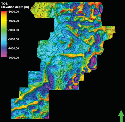
While working on the Campeche and Picanha projects, geophysicists discovered the value of having a multitude of adjacent and/or overlapping surveys, Fig. 4. Although these surveys were acquired and imaged in different years with diverse parameters, new migration algorithms were applied near the edges of each legacy survey. By borrowing data from adjacent or overlapping surveys, within the migration aperture, geoscientists were able to create a more accurate
data volume.
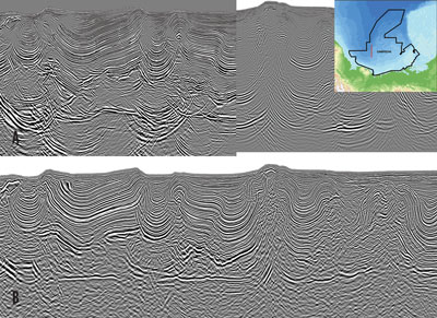
One of the biggest imaging uplifts has come from integrating geological models and knowledge of the physical rock property variations into the velocity model at each step during a top-down imaging approach. Basically, any geological event that causes a major change in velocity needs to be identified in tomographic updates or interpreted into building the velocity model. For Picanha and Campeche, understanding the salt body shape, anomalous shale bodies, or the presence of carbonates/anhydrites, and effectively building these into the velocity model, was crucial to producing the best seismic image possible, Fig. 5. Also, using geophysical parameters collected in open-hole logs from offset wells helped determine the anisotropic parameters needed to create more accurate seismic volume.
The speed and accuracy of the turnaround time for depth imaging the seismic volume has vastly improved since the data were originally acquired. By having large amounts of computing power and more efficient algorithms, it has been possible to image large areas (>15,000 km2) quickly. This allowed for daily updating so that decisions can be made and parameters tested, which are to be used for the next processing step. The imaging and interpretation groups’ experience in these areas, coupled with extensive client interaction, have been key to the success at Campeche and Picanha.
REGIONAL PERSPECTIVE
The 3D product can provide the details required to turn leads into drillable prospects. The 3D volume also enables interpreters to see the larger regional picture without having to speculate about areas without data, which is the case when only 2D data is available. Some of the regional trends that can be ascertained from 3D volume are regional salt geometries that are critical for timing of trap formation, migration of hydrocarbons, and sediment fairway development, Fig. 6. Also, there are several benefits that are realized from combining the multiple volumes of various RTM, Kirchhoff, and Beam migrations, that are used throughout the imaging process. A 3D viewer enables the user to flip between the stacks and the gathers in any orientation, allowing the interpreter to hone in on areas of interest quickly and definitively. This isn’t possible with 2D volume.
ACCELERATED IMAGING
The experience gained from Campeche proved large data volumes could be integrated and rapidly reimaged without sacrificing image quality. The combination of technology, optimized workflows, experience, and collaboration enabled this productivity breakthrough. The Picanha team leveraged the knowledge gained from Campeche, which resulted in even faster project acceleration, exceeding stretch goals and aggressive expectations.
Technological advances played a key role in increasing efficiency and accelerating throughput. The high-end software and hardware were co-designed to optimize efficiency. The high performance computing system enabled many processing tasks to run simultaneously across all computing resources to maximize productivity. This cost-effective compute infrastructure was finely tuned to the high-end imaging algorithms to further enhance throughput. Optimized and peer-reviewed processing sequences were used, enabling rapid turnaround of model estimation techniques, resulting in significantly improved image quality and subsurface characterization.
CONCLUSION
Although technology played a key role, the project’s scale and completion timeline would not be possible without the pre-existing 2D regional framework understanding and close integration between processing, interpretation and imaging personnel. The company leveraged significant imaging experience and geologic understanding from 25,000 km of BrasilSPAN data and a multitude of proprietary processing projects. The macro-velocity model was derived from this regional understanding and applied to harmonize and integrate existing data.
The experienced processing, interpretation and imaging teams worked through multiple iterations and continual calibration occurred in ad hoc team discussions. Team members embraced the accelerated imaging approach and maintained project momentum managing QC interaction via a remote portal.
Advances in both technology and methodology made it possible to seamlessly reimage large volumes of existing data sets. The Picanha Project is providing a seamless regional framework with significant imaging uplift, providing exploration teams the critical context to evaluate, rank, and analyze risk on a portfolio of opportunities for current and future exploration needs. The newly reimaged 3D data is an effective tool that provides sufficient detail to screen leads and identify prospects in Brazil. ![]()
- Applying ultra-deep LWD resistivity technology successfully in a SAGD operation (May 2019)
- Adoption of wireless intelligent completions advances (May 2019)
- Majors double down as takeaway crunch eases (April 2019)
- What’s new in well logging and formation evaluation (April 2019)
- Qualification of a 20,000-psi subsea BOP: A collaborative approach (February 2019)
- ConocoPhillips’ Greg Leveille sees rapid trajectory of technical advancement continuing (February 2019)

