Looking for hydrocarbons offshore western and southern Greece
Greece has a rich geological history. With the Second Offshore Licensing Round opening in second-half 2014, and 20 new license blocks open for applications, exploration in Greece has moved offshore toward the underexplored southern and western parts of the country. Nearby, offshore discoveries, such as the Albanian A4-1X well and the Katakolon find in Peloponnesus, prove that there is a working petroleum system in the region. Exploration efforts have slowed down over the past decade, with the most recent seismic shot in 2000, in the Gulf of Patraikos. In preparation for the licensing round, PGS, together with YPEKA, acquired 12,430-line km of broadband, dual-component streamer 2D data in late 2012. With these new data, imaging of this structurally complex region has improved.
THE SETTING
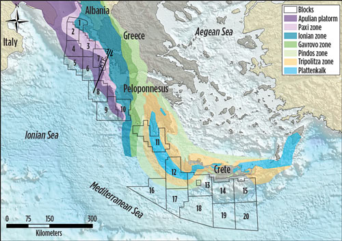
Present activity offshore southern and western Greece encompasses the Hellenic Trench and the accretionary prism of the Mediterranean Ridge (Fig. 1), and the fore-arc region and the External Hellenides. These are all related to the convergence—and ensuing collision—between the African and Eurasian Plates. The Hellenides, a continuation of the orogenic belt surrounding the Adriatic Sea, has developed since the Early Cenozoic, as a result of the Eurasian/African Plate convergence.1,2
The External Hellenides is considered to be the western un-metamorphosed fold-and-thrust belt, as opposed to central and eastern Internal Hellenides, consisting of the metamorphosed nappes. The collision between the Arabian and Eurasian Plates, in Mid-Miocene times, led to the westward extrusion of the Anatolian Plate, setting up a right lateral shear zone across central Greece, and into Turkey, known as the Central Hellenic Shear Zone. The westernmost of these strike slips and transform faults is the Kefalonia Transform Fault (KTF), separating the offshore western region into central and northern zones. The central and southern regions are affected mainly by the subduction of the African Plate beneath the Eurasian Plate, whereas the north is affected by the continent-continent collision between the Adria Microplate and Eurasian Plate.
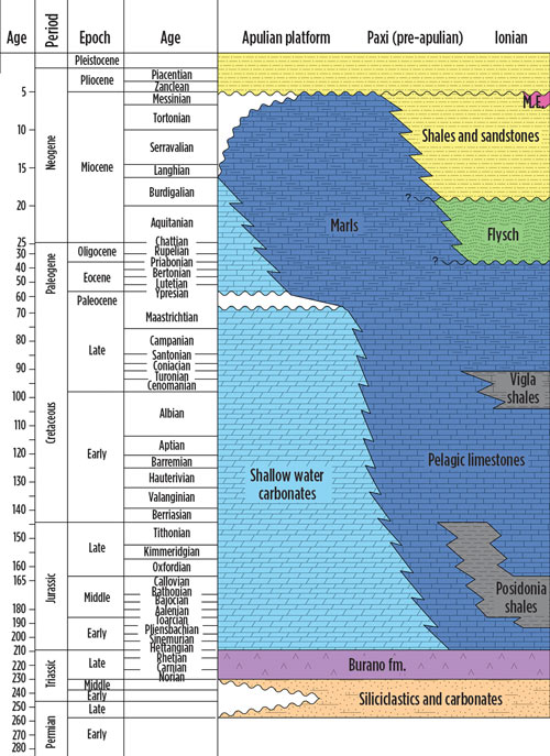
The offshore stratigraphy (Fig. 2) is inferred, from the well data onshore, and offshore, Italy, Albania and Greece (e.g. the Aitolikon-1 well in Aitoloakarnania/Greece), to consist of a suite of clastic and carbonate sediments, ranging in age from the Permian to the present. During the Permian, the offshore Greece region was on the North African shelf, thus the Permian is dominated by shelf clastic sediments. The Late Triassic period was associated with widespread evaporate deposition, and thus the region’s most prolific source rock was deposited—the Burano Formation, and its equivalents.
By the Liassic, the N-S-oriented rifting along the North African margin had begun, and the shelf was fragmented, and differentiated, into basins (such as Ionian and Pindos) and carbonate platforms (Apulian, Tripolitza/Gavrovo). The Triassic–Miocene sequence on the Apulian Platform comprises predominantly platform carbonates, exposed both during the Liassic rifting, and at the onset of convergence and the ensuing orogeny, as the Apulian Platform formed the forebulge of the Hellenides. A third exposure, and significant erosion, took place during the Messinian drawdown of the Mediterranean Sea, evidenced as the Messinian Salinity Crisis. Pelagic carbonates were deposited along the platform margin and in the Ionian basin.
During increased rifting in the Middle-to-Late Jurassic, organic rich shales—the Posidonia beds—were deposited in anoxic basins in the hanging-walls of half grabens, within the Ionian basin. Post-rift subsidence, and a deepening of the water depth, led to the deposition of the organic-rich Vigla shales in the Late Early Cretaceous. As the convergence progressed, and with the growth of Hellenides and the Pindos Thrust to the east, carbonate deposition ceased in the Ionian basin as clastic sediment-influx (flysch) increased from the east. The flysch, sourced from the propagating Hellenides and the Pindos Thrust, is the first of several generations of flysch sediments dominating the Neogene succession in the offshore Peloponnesus.
The Messinian time period is associated with substantial erosion in the north, and in the offshore Western Peloponnesus, whereas the offshore region south of Crete was still submerged, and deposition of halite took place in shallow basins. Since the re-flooding of the Mediterranean Sea from the Early Pliocene, the offshore sedimentation has been predominantly hemipelagic, with a short but remarkable period of uplift during the Pliocene/Pleistocene boundary.
The geotectonic zones developed as the Hellenides progressed, and the names of individual zones originated from the paleogeography. The Paxi (Pre-Apulian) Zone constituted the slope from the Apulian Platform into the adjacent Ionian basin, known today as the Ionian Zone. This zone continues northward into Albania, home to Europe’s largest onshore oil field, Patos Marinza, and the recent Shpiragu-1 oil discovery. While Patos Marinza has reservoirs within the Neogene clastic succession, the Shpiragu-1 discovery reservoir evolved within fractured carbonates of Cretaceous age in the Ionian Zone.
REGIONAL INTERPRETATION/POTENTIAL
A regional interpretation of the dataset covering offshore western and southern Greece resulted in a new understanding of the offshore region. The region is compartmentalized, with the different areas affected, to some extent, by the convergence, subduction and/or collision between the Eurasian and African Plates, and later between the Arabian and Eurasian Plates.
North Ionian. The North Ionian region covers the offshore area north of the Kefalonia Transform Fault (KTF), including the Apulian Platform, the Paxi Zone and the western (external) Ionian Zone. It covers licensing Blocks 1 through 7. The area is affected by the Hellenides orogeny, but not by the subduction along the Hellenic Trench. The Apulian Platform, situated atop the Adria Microplate, is abutting against the Eurasian Plate at a much slower convergence rate than the subduction occurring south of the KTF—the influence of the Hellenides is less, moving eastward, compared to the central Ionian Region.
The potential source rocks include the Triassic evaporitic sequence beneath the Apulian Platform, and eastward toward the Ionian Zone, the Posidonia beds and the Vigla shales are potential contributors. The discoveries, made along the Apulian Platform in Italy (e.g., Aquila field), are sourced from the Triassic Burano formation.7 The reservoirs, within the North Ionian region, are found in the platform carbonates, carbonate build-ups downslope from the platform, and slope deposits coming off the platform to basins in the north and east.
Potential leads are within structures atop the platform, along its northern and eastern rim, and within the basin, extending from the platform and eastward toward the External Hellenides. Toward the orogenic belt, a large anticline—the Paxi anticline—is underneath the Ionian Thrust. The reservoir quality of the carbonates has been enhanced through periods of emergence and karstification, and later burial and dolomitization.
Analogues to the region are Rospo Mare field, situated atop the Italian Apulia Platform, and the Giove discovery, with carbonate build-ups along the platform rims. Figure 3 shows a line running southwest and northeast across the platform, imaging possible karstification potential and a three-way closure within the carbonate platform. Hydrocarbon migration is inferred to be vertically up through the platform sediments, and any potential reservoir target sealed by intra-platform shales.
Central Ionian region (offshore Western Peloponnesus). The Central Ionian region extends from the Kefalonia Transform Fault (KTF) in the north to the southern tip of Peloponnesus. Westward, it extends across the Mediterranean Ridge (the accretionary prism of the African/Eurasian subduction), and covers Blocks 8 through 11. The right lateral sense of slip, along the KTF, means that the Ionian Zone dominates this region. This is where the Katakolon discovery was made in the 1980s, and the northward extension of the Ionian Zone continues into Albania, with numerous fields and discoveries, such as Kucove, Patos Marinza and Ballsh-Hekal fields. Block 11 covers the Gavrovo-Tripolitza platform carbonates zone.
The Ionian Zone originated as the Ionian basin, with source rock deposition in the Triassic evaporite succession (sabkha environment), in the Jurassic syn-rift deposits (Posidonia beds) and during the Late Cretaceous subsidence (Vigla shales). The discoveries, so far, made in this zone are within the Jurassic to Eocene carbonates and Miocene clastics, where the reservoir properties of the carbonates have been enhanced by fractures and karstification (secondary porosity).
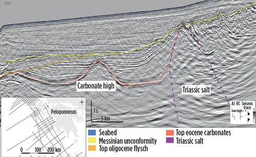
The Central Hellenic Shear Zone, and the subduction along the Hellenic Trench, both affect the Central Ionian area. The subduction and continued propagation of the Hellenides toward the southwest led to the Ionian Zone developing as a foreland to the piggy-back basin, atop the Ionian thrust. The internal thrusts led to the development of several thrust-related anticlines. In addition to these structural traps, salt mobilization of the Triassic evaporites occurred along the thrust plane (as decollement surfaces), with upturned flanks along the salt diapirs acting as potential traps. The strata within these upturned flanks, observed on the seismic data, are inferred to be the earliest synorogenetic clastics of the Pindos Thrust, east of the Ionian basin—the Oligocene Flysch, Fig. 4.
The Katakolon discovery was made in the Jurassic to Eocene carbonates, not far from the carbonate high observed, Fig. 4 (Top Eocene carbonates). The Oligocene Flysch, and the layer inclination, observed within the sequence on Fig. 4, are interpreted to have been rotated by the mobilized Triassic salt, as a result of the thrust movements from the southwestward propagation of the Hellenides.
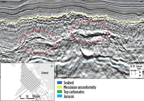
South Greece. This area covers the fore-arc region south of Crete, and the Mediterranean Ridge. The region is largely unexplored. The only well data available are shallow wells from the Ocean Drilling Program (ODP), and the Deep Sea Drilling Program (DSDP). The Hellenic Trench, and the several southwest-northeast-trending trenches splaying off it, affect the area. South Greece covers licensing Blocks 12 through 20.
The island of Crete is a horst structure, emergent since c. 15 Ma, bounded by normal faults on all sides, and one of a number of horst and graben structures found in the offshore area south of Crete. During the Messinian Salinity Crisis, shallow basins were located to the south, and southwest, of Crete, resulting in thick accumulations of Messinian evaporites.
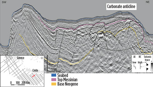
The lack of well data and the different geological setting—fore-arc as opposed to fold-and-thrust belt—makes this area’s interpretation challenging. Figure 5 shows a southwest-northeast seismic cross-section through one of the continental blocks south of Crete, and presents a Neogene clastic succession overlying what is inferred to be carbonates. The seismic cross-section shows a large anticline within the carbonates, with a four-way closure observed on the Base Neogene grid. South of Crete, the quality of the source rocks is uncertain; however onshore stratigraphy samples, collected within the Messara basin (central-south Crete) and Gavdos Island, proved sufficient enough TOC (Total Organic Carbon) content within the mid-to-late Miocene succession to be considered a potential source.8,9,10
INCREASED UNDERSTANDING
Exploration in western and southern Greece is moving offshore, and with new and improved seismic data, the regional understanding of this complex offshore region is improving. The offshore region has a proven petroleum system, as demonstrated by the Katakolon oil and gas discovery within the Ionian Zone, and encouraging discoveries offshore Albania and Italy. Also documented is that there is potential along the Apulian Platform and its adjacent basins. ![]()
REFERENCES
- Zappaterra, E., “Source rock distribution model of the Periadriatic region,” AAPG Bulletin, 78 (3), pp. 333-354. 1994.
- Bradley, K. E., E. Vassilakis, A. Hosa and B. P. Weiss, “Segmentation of the Hellenides recorded by Pliocene initiation of clockwise block rotation in central Greece,” Earth and Planetary Science Letters, 362, pp. 6-19. 2013.
- Monopolis, D., and A. Bruneton, Ionian Sea (Western Greece): Its structural outline deduced from drilling and geophysical data, pp. 83, 227-242. 1982.
- Pichon, X. L., S. Lallemant, N. Chamot-Rooke, D. Lemeur and G Pascal, The Mediterranean Ridge backstop and the Hellenic nappes, pp. 186, 111-125. 2002.
- Zelilidis, A., D. Piper, I. Vakalas, P. Avramidis and K. Getsos, “Oil and gas plays in Albania: Do equivalent plays exist in Greece?”, Journal of Petroleum Geology, 26(1), pp. 29-48. 2003.
- Argnani, A. “The influence of Mesozoic paleogeography on the variations in structural style along the front of the Albanide thrust-and-fold belt,” Ital. J. Geosci., pp. 132(2), 175-185. 2013.
- Karakitsios, V., and N. Rigakis, “Evolution and petroleum potential of Western Greece,” Journal of Petroleum Geology, pp. 30(3), 197-218. 2007
- Bellas, S., and H. Keupp. “Contribution to the late Neogene stratigraphy of the Ancient Gortys area (southern central Crete, Greece),” Bull. Geol. Soc. Greece, pp. XLIII (1) 579-593. 2010.
- Pyliotis I., A. Zelilidis, N. Pasadakis, G. Panagopoulos, and E. Manoutsoglou. “Source rock potential of the Late Miocene Metochia formation of Gavdos Island, Greece,” 13th International Conference of the Geological Society of Greece, Sept. 5-8, 2013.
- Maravelis, A., G. Pangopoulos, I. Piliotis, N. Pasadakis, E. Manoutsoglou and A. Zelilidis, “Pre-Messinian (Sub-Salt) source-rock potential on back-stop basins of the Hellenic Trench system (Messara basin, central Crete, Greece),” Oil & Gas Science and Technology–Rev. IFP Energies Nouvelles, 2013
- Advancing offshore decarbonization through electrification of FPSOs (March 2024)
- The reserves replacement dilemma: Can intelligent digital technologies fill the supply gap? (March 2024)
- Subsea technology- Corrosion monitoring: From failure to success (February 2024)
- What's new in exploration (January 2024)
- Dallas Fed: E&P activity essentially unchanged; optimism wanes as uncertainty jumps (January 2024)
- Driving MPD adoption with performance-enhancing technologies (January 2024)

