 |
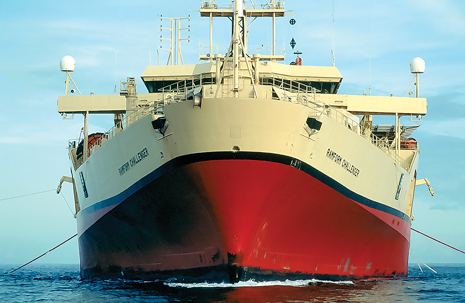
| PGS has dedicated its Ramform Challenger seismic vessel for offshore West Africa surveys. In 2013, the Congo MegaSurvey was added to the West Africa database. |
|
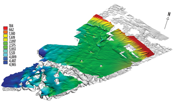
Since 2007, PGS has been building a regional, multi-client 3D database across offshore West Africa with total coverage of over 150,000 sq km. In partnership with national governments, PGS individual surveys and countrywide surveys stretch from Angola to Nigeria, and allow for a regional overview of subsurface geology, which forms the major hydrocarbon accumulations along the West African margin. In 2013, PGS, in association with SNPC, completed the integration of the Congo MegaSurvey, (Fig. 1) into the West African database and began interpretation immediately. The results of this survey are discussed in this article.
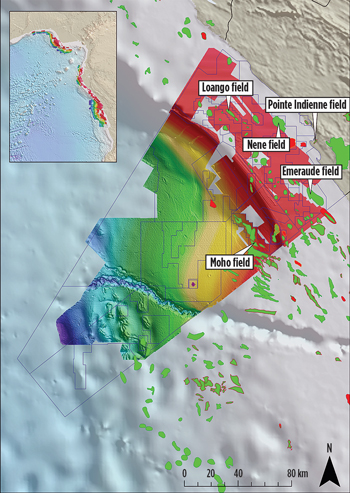 |
| Fig. 1. The PGS/SNPC multi-client Congo survey, with callouts identifying producing fields, including Moho. |
|
EXPLORATION IN THE CONGO
Hydrocarbon exports dominate Congo’s economy, accounting for 87% of the country’s export revenue in 2011.1 The first successful exploration project in the Congo was carried out by Société des Pétroles d’Afrique Equatoriale Française (SPAEF) in 1957, with the Pointe Indienne-1 discovery well in the Grés de Mengo formation. This discovery proved commercial, with production beginning in 1960, and continuing to this day.
Offshore exploration began in 1969, 12 years after the first discovery, with the Emeraude Marine well. This field came online in 1970. Since these initial discoveries, commercial hydrocarbon volumes have been found in Miocene channel and turbidite sequences, Albian carbonates, and pre-salt carbonates and sandstones. Over the past seven years, a number of offshore fields have come online. The most important of these are the Moho fields, Fig. 1. These fields have been pivotal in proving the existence of a working petroleum system in water depths of 600-900 m, opening up a huge area of underexplored acreage.
CONGO PETROLEUM SYSTEM
The Congo basin is part of the west-central coastal province of West Africa. It comprises a series of Atlantic-type margin sag basins, extending from the southern edge of the Niger River Delta to the Walvis Ridge, which formed as the South American and African plates rifted and drifted from the Late Jurassic, onwards. Two distinct phases of deposition are recognized in the Congo basin—syn-rift and post-rift (Fig. 2), with post-rift deformation being strongly influenced by salt tectonics.
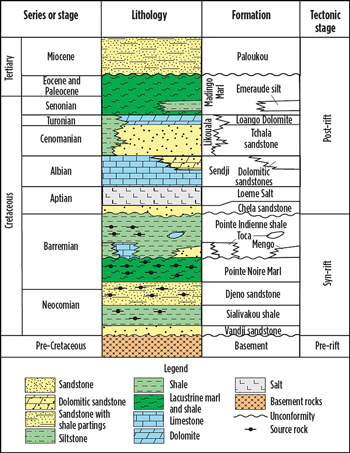 |
| Fig. 2. Stratigraphy of offshore Congo.2 |
|
Syn-rift. Rifting of the African Plate resulted in the formation of a series of asymmetrical horst-graben basins trending parallel to the present-day coastline (northwest-southeast). Initially, the rift and associated basins were above sea level and isolated from the newly forming ocean. Thick sequences of fluvial and lacustrine rocks were deposited in the rift basins, and these organic material-rich sediments, some deposited in oxygen-deficient water, are one of the source rocks for the hydrocarbons found today. Continued rifting widened the zone of the normal faulting crustal extension through the Barremian.
Syn-rift offshore deposits of the northern (upper) part of the Congo basin (Republic of the Congo) range in age from Neocomian to Barremian, and consist of lacustrine and fluvial sediments. The Neocomian Vandji sandstone (coarse sandstone equivalent to the Basal sandstone of the South Gabon sub-basin) overlies the Precambrian basement. The Sialivakou shale and Djeno sandstone are lacustrine shales and turbidite sandstones equivalent to the lower part of the Bucomazi formation (of the Lower Congo basin). The Barremain, organic-rich lacustrine shales and marls, and dolomitic black shales of the Pointe Noire marl, which are up to 500 m thick, are equivalent to the Melania formation lacustrine shale in the South Gabon sub-basin, and the middle part of the Bucomazi formation of the Lower Congo basin. The Barremian Pointe Indienne shale and the 300-m-thick Toca formation consist of lacustrine siliciclastic shales and carbonate rocks, equivalent to the Melania and Dentale formations in the South Gabon sub-basin.
Pre-rift reservoirs typically range from shallow water to onshore and trend along the margin. However, it is important to note that wells do not penetrate pre-salt in the deeper offshore area, thus the deepwater pre-salt section remains untested. With recent deeper-water pre-salt success along the Angolan margin, and the Diaman discovery by Total, proving a working hydrocarbon system in deepwater Gabon, it will only be a matter of time before deepwater pre-salt exploration emerges offshore Congo.
Post-rift rocks range from Aptian to Holocene (Cretaceous to Tertiary) in age and represent the opening of the Atlantic Ocean in equatorial West Africa. The initial post-rift sequences are early to mid-Aptian age and consist of continental, fluvial and lagoon sediments deposited as rifting ceased in the province. Periodic restricted circulation, caused by volcanic activity to the south along the Walvis Ridge and the incomplete opening of the rift through northern Africa, created conditions, where extensive deposition of evaporite units (mainly salt) occurred. Early post-rift rocks were generally deposited in two distinct regimes—as transgressive units, consisting of shelf clastic and carbonate sediments, followed by progradational units along the continental margin, and as open-ocean, deepwater sequences.
In the Upper Congo basin, the oldest post-rift rocks are the Lower Aptian Chela formation. The Chela formation consists of sandstone and shale deposited in a variety of environments, including marine, lacustrine and fluvial. The thick (>1000 m) evaporite sequences are represented by the Aptian Loeme Salt, which is composed of halite, carnallite, and minor anhydrite. The thick salt in the basin acts as a décollement zone for the post-salt growth-fault structures in the Congo basin. Near the top of the main evaporite section, thin beds of clastic sediments are commonly found, and the salt grades upward into a regionally extensive, 50-m-thick dolomite unit, representing the end of the Loeme evaporite cycle. Above the evaporites, the shelf-carbonate rocks are represented by the Albian Sendji Carbonate, consisting of dolomite, oolitic limestone, and interbedded sandstone units, which were deposited in tidal channels in the lower part, and as offshore bars and shore face units in the upper part.
Above the Sendji formation are the Tchala sandstone (proximal to the shore in the east) and the more distal/offshore siltstone of the Likouala formation. These formations are overlain by the Turonian Loango dolomite and the Madingo marl. The Cretaceous-Tertiary boundary is marked by an erosional event forming a widespread unconformity.
The upper section of Cenozoic sedimentation is dominated by progradational sandstone and siltstone (proximal to shore), and more distal turbidite and deep-marine shale units that originated from the Congo River. Fans, turbidites and stacked channel systems dominate the Miocene, providing numerous, potential hydrocarbon reservoirs.
REGIONAL INTERPRETATION
An interpretation of the different sequences completed across the dataset (Fig. 3) shows a classic east-west profile of a passive margin salt basin, comprising an extensional domain with post-rift raft structures sliding on a salt décollement, and a compressive domain, where the salt has been transported down dip into a thick accumulation of sediment. The salt walls and domes in the compressive domain may be as thick as 1,400 m and have a significant effect on the overlying sediment. Fig. 4. Understanding the relationship between the salt and its impact on the structural regime and palaeotopography is crucial to understanding the reservoir system and trapping mechanisms.
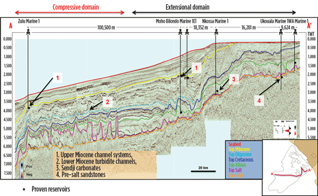 |
| Fig. 3. East-west seismic cross-section, with major interpreted horizons and proven reservoirs. The study area is subdivided into two structural domains—a margin-ward extensional domain in the shallower part of the survey, and a compressive domain in the deeper part of the survey. |
|
 |
| Fig. 4. Interaction between the Miocene and the salt. |
|
POST-RIFT MIOCENE PLAY
The post-rift Miocene play is perhaps the most important play type to consider across the margin. As hydrocarbon development has matured across the shallow shelf area, explorationists are looking into the deeper water to find reservoirs. Discoveries, such as Moho Bilondo field, have de-risked the deepwater Miocene sandstone play, which is currently the main focus for exploration.
The Miocene reservoir hydrocarbons are found in channels, where sedimentation geometry is controlled by the topographic basins situated between the anticlinal structures above the salt walls. A root mean squared (RMS) amplitude extraction of full-stack data within a 100-ms time interval in the Upper Miocene shows the details of multiple “meander-form” channel systems extending out from the Congo River delta, traversing the deep basin, and terminating in fan-shaped morphologies, Fig. 5. These channels and fan systems trend roughly southeast to northwest. The regional interpretation of these features provides information on palaeocurrent direction and flow changes over time, as well as the displacement of channel systems due to salt activity.
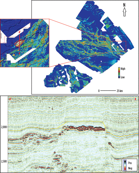 |
| Fig. 5. RMS amplitude extraction of Top Miocene between +0.1 sec – +0.2 sec. |
|
Figure 5 shows the Moho Bilondo discovery, which lies in a Miocene turbidite channel. The regional scale of this RMS map enables the identification of leads within the same channel system, Fig. 6. The leads, characterized by amplitude brightening, are located in Upper Miocene strata in the same interval as the Moho Bilondo discovery.
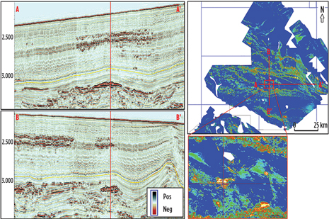 |
| Fig. 6. Survey data showing a) a full-stack seismic line illustrating the Upper Miocene amplitude anomaly as a lead analogous to the Moho Bilondo discovery; b) RMS amplitude extraction of Top Miocene +0.1 sec – Top Miocene +0.2 sec, illustrating the lead outline. |
|
BETTER UNDERSTANDING
Exploration offshore Congo is now moving into deeper water, with discoveries, such as Moho Bilondo, helping to de-risk the petroleum system. Prospectivity still exists in shallow water, as demonstrated in the Grés de Djeno formation by the Nene Marine discovery (Eni, 2012). Through interpreting the dataset, trends in the Miocene channel sequences that have previously proven difficult to observe in sparse 2D, or only block-scale 3D, have been identified easily. Thus, the importance of using regional 3D data in gaining a better understanding of channel trends to enhance exploration efforts is clear. 
REFERENCES
- U.S. Energy Information Administration, http://www.eia.gov/countries/cab.cfm?fips=CF#, accessed May 5, 2014.
- Brownfield, M.E., and R. R. Charpentier, 2006, “Geology and total petroleum systems of the West Central Coastal Province (7203),” West Africa: U.S. Geological Survey Bulletin 2207-B, p. 52.
|


