PHILIP ROSE, GREGG BARKER, KLAAS KOSTER and JEFF PYLE, Apache North Sea Ltd.
 |
|
|
The Forties field in the UK Central North Sea was purchased by Apache from BP in 2003, at which time it was a giant field in the decline phase of its life. Annualized average production was 41,000 bopd and declining. No new wells had been drilled since 2001, when the previous BP drilling campaign was cancelled. This was a long way from the glory days of the early 1980s, when the field was producing between 400,000 and 500,000 bopd. By 2003, the field had produced a cumulative 2.5 billion bbl of oil, out of an in-place volume between 4.2 to 5 billion bbl, and the field was sold with 144 MMbbl of remaining reserves. Since then, Apache has tested over 100 drilling targets, made over 80 production completions and four injection completions. As a result of the Apache drilling campaign, the annualized average production rate has been held close to 60,000 bopd since 2005, and Apache has produced over 150 MMbbl from the field, of which 75 MMbbl have been produced from Apache-drilled wells. Currently, the field produces between 50,000 and 70,000 bopd, with over 70% from Apache-drilled wells, Fig. 1. Going forward, there is a dynamic, constantly evolving target portfolio, the strength of which has allowed the new 18-slot Forties Alpha Satellite platform to be commissioned for installation in 2012.
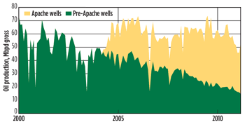 |
| Fig. 1. Forties field production history, 2000 to 2011. |
|
FOUNDATION: DATA INTEGRATION
An integrated, multi-disciplinary interpretation approach has been critical to Apache’s ability to continually identify new targets. In particular, the ability to display well log-derived attributes, together with seismic amplitudes, seismic geobodies and production information in a single interpretation environment—Schlumberger’s Petrel software—has been invaluable. Easy access to accurate information is always a key element in efficiently working up drilling locations, and to this end, Apache has an online well databook to complement its well and seismic database. The databook contains map locations, illustrations of the pay section with completion history, production history, workover record and a current completion diagram for every well that has been completed in the field. All interpreters also have access to our live production allocation database. Although many of the infill drilling targets have been driven by seismic interpretation, including identification of direct hydrocarbon indicators (DHIs) or unswept areas highlighted by 4D time-lapse seismic, others were generated to replace mechanically failed wells with remaining production potential. A few targets were generated following the analysis of simulation results.
The initial identification methodology of a target is critical and forms the basis of target categorization. However, a target can only be matured once a believable trap model and a reasonable expectation of finding sufficient productive reservoir can be demonstrated. This process is made possible by the detailed interpretation of lithology prediction seismic inversion volumes, together with the extensive Forties well log database in the context of a robust stratigraphic model. The final element in the evaluation of bypassed pay traps is the identification and mapping of the many small discontinuities present in the seismic data. These features, derived from seismic coherency and spectral decomposition datasets, can be demonstrated to be associated with both sandbody edges and small faults (5–10 m scale throw). It is very striking how often a small fault defined by coherency data lines up with the edge of a swept zone imaged by 4D seismic. The principal infill target categories are 1). DHI targets, 2). 4D seismic lack-of-sweep targets, 3). development geoscience targets (e.g., the identification of a sand body with no production wells), 4). twin replacement of a mechanically failed production well or pilot well with no completion and 5). simulation-derived target.
All of these categories have had a high success rate throughout the Apache infill drilling campaign (70–80%) except for simulation-driven targets (50%). This reflects the fact that current Forties bypassed pay targets are principally below the resolution of the simulation model. DHI or 4D seismic-derived predictions of bypassed pay have the advantage of being based on an actual measurement of the reservoir properties, rather than a prediction of fluid flow as in a simulation model.
STRATIGRAPHY AND SAND DISTRIBUTION
The Forties stratigraphic model has been generated by the integration of biostratigraphic data with seismic lithology data, log correlation and core derived sedimentology. Seismic lithology prediction in the Forties field is essentially a binary problem with the bulk of the Sele to Forties section consisting of porous sands (average 27% porosity) and shales (claystones to siltstones). The ability to predict lithology from seismic results from the strong AVO effect observed at a sand/shale boundary. The seismic lithology volume is derived from an acoustic impedance (AI)– gradient impedance (GI) projection as described by Connoly (1999) and Whitcombe et al. (2001). A lithology seismic section through the field, Fig. 2, demonstrates the clear imaging of the main sand bodies. Biostratigraphic input confirmed the excellent log correlation of the Balder/Sele shale interval and the critical identification of a consistent gamma peak marker, the Top Forties maximum flooding surface, which defines the top of the Forties formation in all Forties field wells.
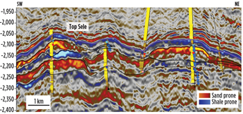 |
| Fig. 2. Forties field colored inversion lithology depth seismic section. Black lines indicate principal channel bodies. Gamma logs shown on well traces with yellow indicating sand below Top Sele. |
|
Bypassed pay traps in the Forties field are typically set up by either discontinuities at sand body boundaries, for instance where a massive channel axis system is in contact with interbedded wing deposits (crevasse splay and channel overbank deposits), or where massive sands pass up into more heterogeneous abandonment sequences which allow the preservation of extensive base seals. Lateral sealing is also generated by the many small faults within the field, which result from both compaction over individual sand bodies, syndepositional subsidence of channel sands into encasing shales, or compaction over the buried Jurassic structure of the Forties Montrose high.
TRADITIONAL GEOSCIENCE PLAYS
A significant proportion of Apache infill targets have been generated by the recognition of discrete sand bodies that have not been fully exploited. An excellent example of this is provided by the Charlie Channel eastern wing sand play. The sands had not been targeted, because they are thin-bedded (0.5–2 m sand beds) and dispersed with low net to gross (30–40%) when compared to the typical Forties reservoir (75% net to gross). Initially, the productivity of these sands was tested by the recompletion of two watered out wells originally perforated in the deeper, more massive Upper Main Sand. This proved that despite their less attractive log signature, the sands could be extremely productive. Indeed, one well completed in 6 m of Charlie Wing sands produced over 3 MMbbl of oil at 4,000 bopd before failing due to sanding. Since identification of this play, Apache has drilled and completed seven wells in the Charlie Channel eastern wing sands, all of which have been successful. To date, over 10 MMbbl of oil have been produced from the play.
SEISMIC RESPONSE
In the Forties field, the sands show a significant seismic response to changes in hydrocarbon saturation. The top of a wet Forties sand lying underneath the Sele typically shows a hard positive reflection response that decays in amplitude with offset (Type 1 AVO). When the brine is replaced by hydrocarbons, the sand typically becomes acoustically softer, generating a reflection with a weak, hard amplitude on the near offsets and a higher amplitude, soft response on the fars (Type 2P AVO). In AI GI cross plot space, it is possible to define a hydrocarbon indicator projection approximately perpendicular to the lithology projection (Whitcombe et al 2001). In some areas of the field, the colored inversion oil indicator volume has been extensively used to generate DHI targets.
The difference between the seismic response of a brine and hydrocarbon-filled sand has been further exploited in Forties field by the use of 4D seismic. In Forties, the first 3D seismic survey was recorded in 1988 when, even though 70% of the total cumulative oil production to date had been already been produced, the field water cut was still relatively low (25–30%). Since then, four monitor surveys have been acquired, the most recent in 2010. The 4D difference volumes all show a well developed response to water replacing hydrocarbons that can be easily related back to appropriate production wells, Fig. 3. Areas which the seismic indicates have not been swept become infill targets, if that makes sense in the context of the local distribution of seismic discontinuities, historic production offtake and sand distribution.
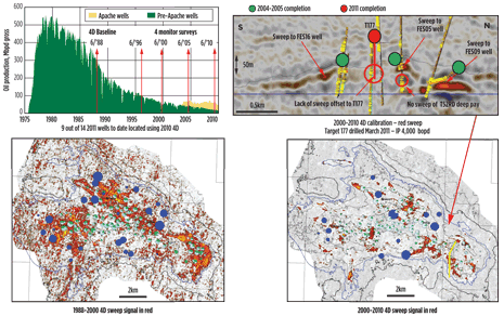 |
| Fig. 3. Forties 4D seismic. Illustration of the acquisition of base line and monitor surveys with respect to the Forties production curves and calibration of 4D sweep signal to appropriate production and injection data. Dots on maps indicate cumulative oil and water production (green and pale blue) and cumulative injection (dark blue) over the 4D time interval. |
|
FORTIES DHI TARGETS
Early in the Apache infill campaign, many DHI targets, identified by the colored inversion oil indicator volume, were drilled in areas with no or limited indication of 4D sweep. This resulted in successful development of underdeveloped areas of the field, such as the Echo DHI play trend to the west of the Echo platform, Fig. 4. In this case, the area had been historically downgraded, due to the presence of two very low net-to-gross appraisal wells. However, the 2000 vintage lithology and fluid volumes indicated significant sand prone trends adjacent to the low net-to-gross appraisal wells, which were also associated with a well developed DHI that dimmed out close to the original oil-water contact. There was little evidence of sweep on the 1988–2000 4D in the area, particularly pertinent in SE Forties as production was not initiated from the Echo platform until December 1987. In all, 15 wells were drilled from the Echo platform in 2004–2005, two-thirds of which were DHI targets.
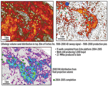 |
| Fig. 4. Illustration of 2004-2005 Echo drilling campaign. |
|
4D SEISMIC IDENTIFICATION OF UNSWEPT ATTICS
Today, the balance of targets has shifted, and the majority of targets are driven by 4D seismic. The most successful technique has been to identify unswept attics in sand bodies defined on the lithology seismic above a well defined seismic sweep response. This methodology was first tested successfully in 2005 with a 4D attic target drilled in the north of the main Echo area channel, the focus of Echo 1987–2003 offtake. The methodology was further developed by careful 4D attic mapping in the main Delta channel area and proven by successful drilling in 2006–2008.
We have now found that these types of targets are most efficiently generated by using amplitude thresholds on seismic data volumes sampled into a sugar cube geomodel. This workflow allows the sand-prone areas to be isolated first and then, by applying a second 4D amplitude filter, only the unswept attics remain. It is possible to directly generate the unswept attic thickness from the geomodel and plot the attic thickness map together with the top reservoir structure contours and discontinuities to identify an optimal drilling location. In 2011, this target generation methodology has resulted in very rapid target generation and maturation based on 4D difference data derived from the 2010 monitor survey. This has resulted in successful infilling of the 2004–2005 Echo campaign and the identification of some prolific unswept pockets in the axis of the Charlie channel complex. In this process, we are finding that the distribution of production baffles within the main Charlie Channel is much more complex than we would have anticipated. For instance in 2009, we drilled a very successful horizontal based on a 4D attic with 10,000-bopd initial rate. The 2000–2010 4D seismic showed a marked area of sweep near the heel of this well, but surprisingly, there was also the indication of an unswept attic less than 200 m to the east. In Q1 2011, this eastern attic area was targeted with two new high-angle wells, one of which had an initial rate of 12,000 bopd, Fig. 5.
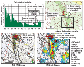 |
| Fig. 5. Illustration of 4D attic targets in the axis of the Charlie Channel complex. Production baffles parallel to the axis of the channel have allowed a prolific 2009 well to be offset in 2011, less than 200 m to the east. |
|
DISCUSSION
Over the last eight years, the style of targets drilled in the Forties field has changed. Up to the end of 2008, DHI targets formed the largest target population, closely followed by twin targets and development geosciences plays. Many of these targets were drilled in underdeveloped parts of the field, such as the NE flank or Echo DHI play, Fig. 6. From 2009 to the present, 4D targets have become dominant. This is partly a consequence of being able to more efficiently generate these targets by generating unswept model geobodies in the seismic sugar cube geomodel, and partly a natural consequence of infilling areas of the field developed in the early years of the Apache drilling campaign.
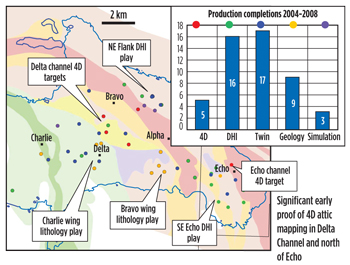 |
| Fig. 6. Distribution and categorization for Forties infill targets drilled from 2004 to 2008. |
|
CONCLUSION
The Apache North Sea team continually revisits the details of the field stratigraphic interpretation and looks for new ways to enhance our interpretation methodology. This has allowed us to have a continuous and successful drilling campaign since 2004. For example, 11 production wells were completed in 2011 with over 5 MMbo produced from those wells in the calendar year. Even though we have tested over 100 targets since 2004, we still have a target portfolio with more than 80 identified opportunities. This ever-evolving portfolio was key to justification of the new Forties Alpha Satellite platform currently under construction. 
ACKNOWLEDGMENTS
The stratigraphic model at the foundation of our work to identify infill drilling locations was developed by the many people that have worked on the Forties Field. In particular, the current version of the model presented here is based on analysis by Roger Anderton (2000-2004). This article is based on paper 145433, presented at the SPE Offshore Europe Oil and Gas Conference and Exhibition held in Aberdeen, UK, 6–8 September 2011.
LITERATURE CITED
1. Ahmadi, Z, Sawyers, M, Kenyon-Roberts, S, Stanworth, B, Kugler, K, Kristensen, J, Fugelli, E, 2003, Paleocene in. Evans, D, Graham, C, Armour, A, Bathurst, P, eds., The Millennium Atlas: Petroleum Geology of the North Sea, The Geological Society of London.
2. Connolly, P. 1999, “Elastic Impedance”, The Leading Edge.
3. Hill P, J, and Wood G, V, 1980, “The geology of the Forties Field UK continental shelf (North Sea)”, Bulletin of the American Association of Petroleum Geologists, pp 64, 81-93.
4. Wills, J. M. 1991, “The Forties Field, Block 21/10, 22/6a, UK North Sea. In: Abbotts, I. L. (ed.) United Kingdom Oil and Gas Fields: 25 Years Commemorative Volume,” Geological Society, London, Memoirs, 14, pp 301-308.
5. Whitcombe, D, Connolly, P, Reagan and R, Redshaw, T. 2001, “Extended elastic impedance for fluid and lithology prediction,” Geophysics, pp 67, 63-67.
THE AUTHORS
|
 |
PHIL ROSE joined Apache as a senior geologist in Aberdeen in 2003. Since then, he has been one of the principal interpreters generating drilling targets for Apache’s Forties drilling campaign. Before joining Apache, Dr. Rose spent 12 years working for Texaco in the North Sea, followed by two years of international consulting with Halliburton. He has a Ph.D. in structural geology from the University of Liverpool.
|
| |
|

|
GREGG STEPHEN BARKER, a senior geophysical advisor, has been with Apache for 14 years. In 2005, he joined Apache North Sea, Ltd, in Aberdeen, initially doing exploration, but he spent the last three years working Forties Field development. Prior to Apache, Mr. Barker spent four years with Amerada Hess, and he began his career in 1982 with Amoco. He received his BS in 1980 from Clemson University and his MS in 1982 from the University of Georgia. |
| |
 |
KLAAS KOSTER recently transferred from Apache North Sea to Apache's Technology department as senior geophysical advisor. Dr. Koster has 20 years of industry experience and previously worked for Shell and Amoco in diverse locations. He is past president of the Society of Exploration Geophysicists and holds a PhD in geophysics from Delft University of Technology.
|
| |
 |
JEFF PYLE began his career at Apache North Sea in 2005 and has worked in the exploration group before joining the Forties development group in 2008. Mr. Pyle has constructed the latest Forties full-field simulation model and defined Forties drilling targets. He has a BSc degree in geology from Reading University and an MSc in petroleum geoscience from the Imperial College in London.
|
|


