JO FIRTH, KENT MILANI and RON SCHMID, CGGVeritas
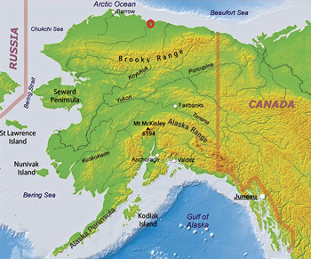 |
| Map of the Tabasco survey location (red circle). |
|
CGGVeritas recently acquired the Tabasco multi-client, high-resolution 3D survey on the North Slope of Alaska. It covers 133 sq mi (Fig. 1) and was designed for optimum imaging of the faulting and onlaps in the Cretaceous and Jurassic hydrocarbon-bearing sequences.
The survey was the first multi-client survey performed in the area in over a decade. It was acquired in separate northern and southern parts, both of which were processed independently, and saw the first use of many advanced acquisition techniques in the region. It was the first-ever, high-productivity, slip-sweep program acquired on the North Slope, breaking previously-established records and setting a new standard at 5,000 records gathered in a 24-hr period. It also introduced the proprietary EmphaSeis broadband vibroseis technique, providing a frequency range of 4-80 Hz. Thus, the survey delivered a number of innovative solutions in this challenging environment.
ARCTIC CHALLENGES
Offshore exploration in the region has to be carried out in the short summer (from July to September) while there is sufficient open water for towed-streamer deployment. Conversely, onshore exploration is only permitted in a short season during the winter, when snowcover reaches 15 cm, and the ground is sufficiently frozen for vehicles to be taken over the snow without damaging the tundra (from December at the earliest to May at the latest). The high-productivity acquisition techniques that were employed enabled this high-density survey to be carried out in less than 60 days, from February to April 2012.
Both onshore and offshore Arctic surveys require several thousand man-hours of careful planning for their successful execution, covering not only the usual subjects, such as spread configuration, geodesy, and re-supply, but also contingencies, HSE preparedness, and environmental and cultural sensitivity. The extreme temperatures, limited daylight and remote location compound the hazards, such as the threat of frostbite and encounters with wolves and bears, and make detailed planning essential. Everything from housing accommodation to food, water and fuel must be transported into an area without roads or infrastructure.
ENVIRONMENTAL FACTORS
With over 30 years of proficiency in both onshore and offshore Arctic acquisition, CGGVeritas has been working with local stakeholders to meet the rigorous permit requirements of the various village, regional and state regulatory bodies. This close collaboration with local authorities and communities is essential to prevent impact on the environment and local subsistence lifestyles. Communication channels with the indigenous peoples were set up and used before, during and after the survey, to explain the way it would be conducted, and to reassure them that their interests were being protected. In addition, local residents were recruited and trained to work on the seismic crews, as well as for using their talents to act as environmental monitors.
The North Slope in Alaska is the location of Prudhoe Bay oil field. Situated on the coastal plain abutting the Beaufort Sea, it contains both the National Petroleum Reserve and the Arctic National Wildlife Refuge, making it a challenging environment for E&P. For land crews operating in such a sensitive region, ensuring minimal impact on the fragile environment is fundamental. CGGVeritas' seismic crews travel on single lanes, with dedicated spots for turnarounds, and use low ground pressure (LGP) vehicles,
Fig. 2, equipped with wide tires or tracks to ensure minimal impact. Long-term camp areas are completely iced-over manually or, preferably, set up on frozen pools to minimize effects on the ground.
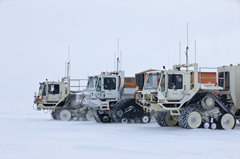 |
| Fig. 2. Low ground pressure vehicles equipped with tracks for minimal environmental impact. |
|
For the Tabasco survey, the 150-man camp consisted of sled-mounted units that were moved one or two miles every few days with the acquisition spread. CGGVeritas has a strict “no spills” policy; no garbage, no petroleum, oils or lubricants, and no contaminants of any kind are to remain on the site after the crews leave. The crews used integrated GPS tracking units to map and enforce exclusion zones around hazards or sensitive sites, such as government-supplied locations of polar bear or grizzly bear dens. Approaching closer than one mile to a known bear den causes an alarm to be triggered in the recorder truck, as well as in the offices of the recording crew manager. Although encounters with bears were unlikely in the winter months, as grizzly bears are inactive in this season and polar bears tend to be seen only on or near the sea ice, strict procedures were enforced to avoid contact, and any sightings were reported immediately to the authorities.
NORTH SLOPE RESERVES
The geologic history of the North Slope is revealed in four major stratigraphic subdivisions, or mega-sequences related to major uplift or rifting events, Fig. 3. From oldest to youngest, these are the Franklinian (pre-Mississippian), Ellesmerian (Mississippian-Triassic), Beaufortian (Jurassic-Cretaceous), and Brookian (Cretaceous-Tertiary) sequences, Fig. 4. The Franklinian sequence is traditionally regarded as the economic basement, though significant oil and gas shows have been observed in these units in some wells.
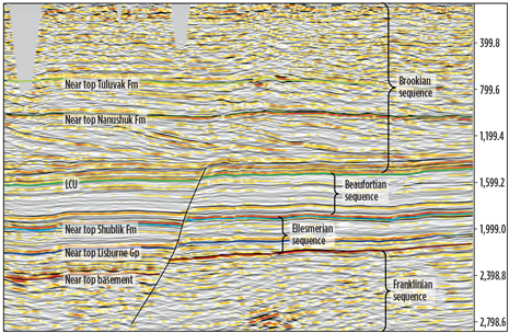 |
| Fig. 3. Initial post stack migrated section from the survey showing a typical North Slope sequence. Preliminary interpretation (not directly tied to well control) supplied by Paul Decker and Diane Shellenbaum of the Alaska Department of Natural Resources, Division of Oil and Gas. |
|
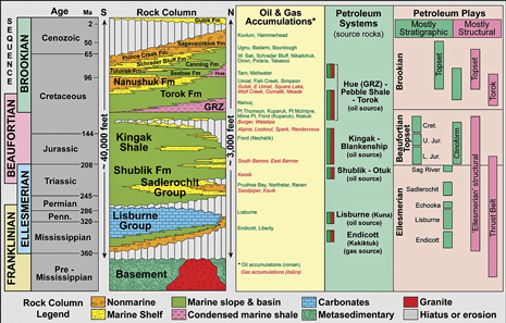 |
| Fig. 4. Stratigraphic column showing the sequences of the North Slope. |
|
All three sequences above basement contain prolific oil-prone source rocks, and all of them host commercial oil and gas production from conventional sandstone and conglomerate reservoirs of Mississippian through Tertiary age. To date, the North Slope has produced well over 16 billion bbl of oil, most notably from the Triassic Ivishak formation at the Prudhoe Bay Unit and the Cretaceous Kuparuk formation at the Kuparuk River Unit. All of the current production from some 35 Tcf of natural gas in existing North Slope fields is either re-injected to maintain reservoir pressure or provides power to run production facilities, as the construction of a gas pipeline system is still awaited.
According to latest federal assessments, northern Alaska still hosts vast undiscovered, technically recoverable, conventional oil and gas resources, with mean estimates of 40 billion bbl and 207 Tcf. The U.S. Geological Survey predicts that dozens of 50-to-150-million-bbl fields remain to be discovered on state lands of the central North Slope. Recent exploration activity includes the region’s first dedicated wells targeting production directly from source rocks, potentially opening a new era in the history of the North Slope petroleum province.
For the Tabasco survey, the primary objective was the imaging of the Cretaceous and Jurassic sequences. To provide optimal imaging of the complex faulting and onlaps in these packages high-resolution, high-density data are required. Closely-spaced receiver lines and shotpoint intervals were used and, overall, 16 times as many shots were acquired compared to a typical legacy survey. As there is only a very short acquisition window in this area, a high-productivity technique was deemed to be the only viable method of achieving the high spatial sampling required in the time available.
ADVANCED VIBROSEIS TECHNOLOGY ON NORTH SLOPE
High-Productivity Vibroseis Acquisition (HPVA, Meunier et al. 2002) technology was employed to increase the efficiency of the slip-sweep Vibroseis (Rosemond, 1996) operations and, therefore, allow enough shot points to be acquired in the short season. In slip-sweep Vibroseis, the speed at which shot points can be acquired is governed by the slip time—the waiting time between sweeps from different vibrator fleets. Typically, the slip time is such that the second fleet will wait for the first to stop vibrating to avoid interference. However, productivity can be improved, if the slip time can be reduced below this limit. As the sweeps begin to overlap, there is some interference between the sweeps from the different fleets, which is visible as harmonic noise on the correlated data. HPVA uses a proprietary deterministic technique applied in the field to remove this interference noise, therefore allowing Vibroseis productivity to be increased without any penalty, so that high-density surveys can be efficiently acquired.
An important advantage of HPVA is the fact that it is applied in real time in the field and is, therefore, transparent to in-field QC and to field data delivered for processing. In the Tabasco survey, the application of HPVA slip sweep, using three fleets of three vibrators, allowed the crew to complete the program ahead of schedule, with average productivity of more than 4,000 VPs per day. A spread of 4,840 live channels was employed, allowing between 20 and 24 receiver lines to be deployed at any one time. This enabled high-density data to be acquired with 27.5-ft source interval and 110-ft receiver interval providing 13.75 × 55-ft bin of 220 fold. It was the first time that such techniques had been employed, or such high-density data had been acquired, on the North Slope.
This was also the first Western Hemisphere survey to employ our proprietary EmphaSeis broadband vibroseis technique. EmphaSeis uses intelligently designed non-linear sweeps to extend bandwidth or to generate any client-defined spectrum (Baeten et al, 2009), while working within the mechanical and hydraulic constraints of the vibrator, Fig. 5. Typically, the technique is used to increase the low-frequency content of the sweep to provide better deep imaging and seismic inversion results. In a conventional linear sweep, the force applied and time spent on each frequency is the same, i.e. the sweep rate is constant. With EmphaSeis, the sweep rate and force varies with the frequency, according to the specifications of the vibrator and its physical constraints.
 |
| Fig. 5. Comparison of the 8s linear and non-linear EmphaSeis sweep design showing the tapered build-up of force at the low frequencies (5a). The resulting amplitude spectrum shows that the EmphaSeis sweep should generate an additional octave of low frequencies (5b). Figure Comparison of correlated shot records using the 8s linear and non-linear EmphaSeis sweep. The deeper events are clearer and have a higher signal-to-noise ratio on the EmphaSeis data thanks to the increased low frequencies (5c). |
|
So with a conventional linear sweep, these constraints result in the drive level being limited to a nominal percentage of the peak force, in order to avoid distortion of the sweep signal and to mitigate mechanical problems with the vibrator. EmphaSeis takes into account both mass displacement and hydraulic flow limitations by using a tapered non-linear sweep design to slowly build up the low frequencies. More vibration time is required to produce lower frequencies, so a low initial sweep rate is required. However, with an intelligently designed sweep with the appropriate tapering at low frequencies, a higher drive level can be used which delivers greater force through the mid-to-high frequencies allowing a higher sweep rate without impairing the vibrator or compromising signal quality.
On the Tabasco survey, an EmphaSeis sweep of 4-80Hz was used, providing considerably improved deep illumination than had previously been seen in the area.
PROCESSING SOLUTIONS
Processing data from the Arctic presents some unique challenges, such as resolving imaging problems related to permafrost and dealing with noise from ice breaks.
The CGGVeritas Calgary processing center has decades of experience processing Arctic data and dealing with these specific issues. They incorporate the latest processing and imaging technology into their workflows to maximize the value of the data.
The dense sampling and high fold of the Tabasco survey meant that the ice break noise did not pose a severe problem and was handled by the standard noise burst attenuation procedures. Ground roll was attenuated using AGORA (Le Meur et al., 2008), a 3D adaptive ground noise attenuation technique applied in the cross-spread domain, Fig. 6. Here again, the dense sampling facilitated the process by reducing the aliasing of the noise trends.
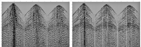 |
| Fig. 6. Shot before (left) and after (right) AGORA noise attenuation in the cross-spread domain. |
|
Permafrost can occur in layers or in scattered patches, and can vary in thickness from 40–400 m over a short distance; in these areas velocities can vary from 1.9 to 4.0 km/sec, depending on water content and temperature. As a result, permafrost causes at least two distinct problems related to seismic data imaging. The first is a short wavelength static problem caused by low-velocity anomalies associated with melting beneath perennial water bodies or ice lakes. The rapid spatial variation of velocity not only causes large statics but also erratic wave field behaviour, which complicates imaging. The second problem is long wavelength structure distortion in the time domain related to the variable thickness of the overall permafrost zone. This is most effectively dealt with by careful velocity model building and depth domain imaging. In permafrost areas, CGGVeritas has used turning-ray tomography successfully to invert first arrival observations and derive a high-resolution, near-surface velocity model for static corrections. This method has consistently reduced the total effort and uncertainty associated with handling this particular processing challenge. In the case of the Tabasco processing, tomographic refraction statics were applied, using a replacement velocity of 3,048 m/sec, for correcting to datum, and the permafrost did not provide any significant challenges.
The long wavelength part of the permafrost statics problem is dealt with in the depth domain. Prestack Depth Migration (PSDM) properly handles the lateral variations in velocity, and can remove the apparent structure (structural distortion of underlying deeper events) related to the permafrost layer. The tomographic inversion technique will also be employed in deriving the shallow part of the velocity model used to drive the depth migration; PSDM of this survey is currently ongoing.
 |
| Fig. 7. Tomographic velocity maps show marked correlation with the satellite image and elevation map |
|
A standard processing sequence was applied to the data, although care was taken to preserve not only AVO (amplitude versus offset) but also AVA and VVA (amplitude and velocity versus azimuth) variations, so that the data will be suitable for inversion and fracture analysis. Although little difference was observed between Gabor deconvolution and conventional surface-consistent deconvolution, Gabor deconvolution was applied, as it is expected that this will better preserve the full benefits of the low frequencies generated by EmphaSeis to improve seismic inversion for reservoir characterization. Common offset vector pre-stack time migration was applied to preserve any azimuthal anisotropy for fracture and stress analyses, and for characterizing the geomechanical properties of the reservoir.
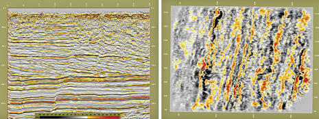 |
| Fig. 8. Prestack time migration showing excellent imaging of the onlaps in the Brookian sequence and clear fault delineation in the Cretaceous (inline and timeslice). |
|
Initial comparisons of the high-resolution, high-density, multi-client Tabasco data with legacy proprietary data show outstanding improvements in the imaging of the faulting through the Triassic, Jurassic and Cretaceous sequences and the delineation of the onlaps in the Brookian sequence. The increase in low frequencies provides greater penetration and illumination of the deeper Franklinian sequence. Although not in the target area, the shallow data above 600 m/sec is also greatly improved, showing continuous horizons, where it is usually not possible to identify anything other than noise on the older, more coarsely sampled data.
Seismic exploration in the Arctic poses considerable operational and geophysical challenges. It is important to deploy the highest possible standards of specialized equipment, crew training, and zero-impact methods to ensure the safety of the crews, and to preserve the environment and delicate ecosystem. Once the data are recorded, the challenge is extended to the processing center, where expertise in handling the unique problems of ice noise, data recorded over permafrost, and a highly variable near-surface, is needed to obtain reliable seismic images of the subsurface.
Modern high-productivity acquisition techniques, combined with detailed and exhaustive logistical planning, mean that it is possible to acquire high-density broad bandwidth data in these remote areas, even in the limited time window available. Combining this optimal acquisition with advanced processing techniques provides data suitable for a wide range of petrophysical and geomechanical reservoir studies, mitigating both the economic and environmental risk of hydrocarbon exploitation in the area. 
LITERATURE CITED
Baeten, G.J.M., A. Egreteau, J. Gibson, F. Lin, P. Maxwell and J.J. Sallas. “Low-frequency generation using seismic vibrators,” 72nd EAGE Conference & Exhibition, Expanded Abstracts, B015, 2010.
Rozemond, H.J “Slip-sweep acquisition.” SEG Expanded Abstracts 15, 64, 1996.
Meunier, J., and T. Bianchi, T. “Harmonic noise reduction opens the way for array size reduction in vibroseis operations,” 72th SEG Annual Meeting, Expanded Abstracts 21, 70, 2002.
Le Meur, D., N. Benjamin, R. Cole and M. Harthy. “Adaptive Groundroll filtering,” 70th EAGE Conference & Exhibition, Expanded Abstracts, G036, 2008.
ACKNOWLEDGEMENT
The authors thank Paul Decker and Diane Shellenbaum of the Alaska Department of Natural Resources, Division of Oil and Gas for their contribution on the geology of the area.
The authors
KENT MILANI graduated from the University of Saskatchewan in Geological Engineering in 1981. He joined Sefel Geophysical in Calgary where he was involved in the testing of non-linear vibroseis sweeps. He was a data processor for a few years and since then has been focused on sales, marketing and management in data processing and multi-client. He is currently VP of multi-client and new ventures for Canada and Alaska land with CGGVeritas.
RON SCHMID holds degrees in Geophysics and an MBA. Throughout his career he has focused on developing and bringing new technology to the industry notably related to seismic imaging. Currently he is Manager of Geophysics for multi-client and new ventures for Canada and Alaska with CGGVeritas.
After graduating from Sussex University with a degree in Environmental Science in 1980 JO FIRTH started working for Digicon as a seismic processor. In 1982 she went to work in Portugal for Atlantic Resources Limitada. When she returned to Digicon in 1983, she worked in the new 3D processing department before becoming manager of 3D processing. In 1997 Jo became a trainer in geophysics and processing for Veritas. In 2008 she joined the Technical Marketing Group of CGGVeritas as Senior Geophysicist. |
|


