In preparation for a CO2 flood, the survey was used to fill the gaps in a database of wells drilled during 90 years of operations.
Garret A. Veloski and Richard W. Hammack, National Energy Technology Laboratory; Vicki Stamp, Roger Hall and Kenny Colina, Rocky Mountain Oilfield Testing Center
A helicopter magnetic survey was conducted in August 2007 over 15.6 sq mi at the Naval Petroleum Reserve No. 3’s (NPR-3) Teapot Dome Field near Casper, Wyoming. The survey’s purpose was to accurately locate wells drilled there during more than 90 years of continuous oilfield operation. The survey was conducted at low altitude and with closely spaced flight lines to improve the detection of wells with weak magnetic response and to increase the resolution of closely spaced wells. The survey was in preparation for a planned CO2 flood for EOR, which requires a complete well inventory with accurate locations for all existing wells. The magnetic survey was intended to locate wells missing from the well database and to provide accurate locations for all wells. The ability of the helicopter magnetic survey to accurately locate wells was accomplished by comparing airborne well picks with well locations from an intense ground search of a small test area.
INTRODUCTION
Teapot Dome Field at NPR-3 has been producing oil, natural gas and gas liquids since 1915. Within NPR-3, there are about 600 producing wells in nine oil-bearing formations.1 The Rocky Mountain Oilfield Testing Center (RMOTC) was established in 1995 at NPR-3 as a field-scale testing center for the development of oilfield technologies. Although there are significant oil reserves remaining, estimated at 207 million bbl based on DOE reserves data, the field is currently producing only 200-250 bopd.
In preparation for a proposed CO2 flood, RMOTC implemented a comprehensive helicopter magnetic survey to eliminate errors and omissions in its well database. The survey was intended to verify or correct the position of known wells and to locate undocumented wells that may exist. In CO2 EOR operations, it is critical from both an economic and a safety perspective that all wells be located and evaluated, as they could be conduits for CO2 migration to overlying formations or the surface. A similar survey was conducted in 2005 at Salt Creek Field, just a few miles north of NPR-3, also in preparation for a CO2 flood.2 In that study, a helicopter magnetic survey was flown over a 1-sq-mi test area, using the Fugro Midas* system at a planned altitude of 115 ft. The survey results, which included a detailed ground reconnaissance, showed that 133 of 139 known oil wells (96%) were detected. Ground-level magnetic surveys over well locations not detected by the helicopter showed weak magnetic response of these wells, too weak to be detected by magnetic sensors at a 115-ft altitude. It was concluded that future airborne surveys should be flown at a lower altitude to increase the likelihood that wells with a weak magnetic response would be detected.
TECHNICAL APPROACH
Airborne magnetic data was collected by Fugro Airborne Surveys from a helicopter platform over the 15-sq-mi NPR-3 oil field. The magnetic survey system that was used employs two cesium vapor magnetometers on opposite ends of a transversely mounted, 44-ft-long horizontal boom located amidships. Each magnetic sensor had an in-flight sensitivity of 0.01 nT. Real-time compensation of the magnetic data for magnetic noise induced by aircraft maneuvering was accomplished using two fluxgate magnetometers mounted just inboard of the cesium sensors.
The survey flight plan prescribed a north-south flight direction at a 65.6-ft altitude with nominal line spacing of 82 ft to optimize the resolution and detection of well targets. At an 80.8-mph ground speed and a 10-Hz sampling rate, the along-line data interval was about one measurement every 11.8 ft. Position information was acquired by a differentially corrected GPS receiver aboard the helicopter and augmented by ground base stations.
The magnetic data was processed to remove diurnal variation and time-lag corrected for sensor position error. Between-flight line leveling was accomplished using tie-line data that was acquired by flying four lines at a specified interval orthogonal to the main survey. A laser altimeter provided the absolute altitude information. Additional processing for the automated selection of anomalies in the gridded magnetic data was performed using Geosoft Oasis Montaj. Spatial analysis of the selected anomalies was accomplished using ESRI ArcMap.
A GPS receiver employing a satellite-based, real-time differential correction service to improve accuracy was used in the field to verify well positions. Data was logged on a handheld computer and incorporated into a Geographic Information System (GIS) using ESRI ArcPad.
RESULTS AND DISCUSSION
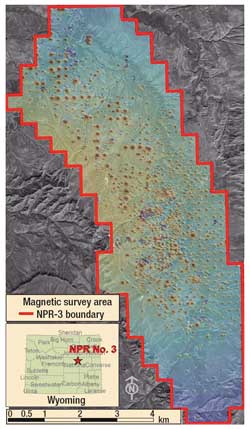
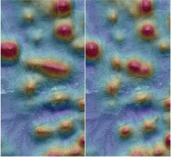
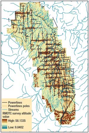
The NPR-3 survey resulted in more than 932 line-mi of data over an area of 15 sq mi, Fig. 1. Bidirectional grids of total magnetic field intensity were prepared using either independent or averaged data from the two magnetic sensors. Figure 2 contains grids generated using data collected from each magnetic sensor independently and data acquired by averaging the response of the two magnetic sensors. Grids generated from independent sensor data were found to better resolve the magnetic response of nearby wells.
 |
|
Fig. 1. RMOTC’s NPR-3 oil field. A color-shaded relief grid of the toroidal-field magnetic data shows numerous well anomalies.
|
|
 |
|
Fig. 2. Color-shaded maps of TF magnetic data in which the response of the two magnetic sensors is averaged (left) and treated as two separate measurements (right). Note that nearby wells are better resolved when the sensors are treated as independent measurements. The same color and distance scales used for both grids.
|
|
The Blakely algorithm in Geosoft Oasis Montaj was used to automatically select peaks from the gridded magnetic data; a total of 2,355 targets were selected. Because the most current NPR-3 database contains only 1,353 complete well records, some of the selected targets are undocumented wells or ferromagnetic objects that are not wells. The geographical locations for wells in the NPR-3 database were compared with the location of targets selected from the gridded Toroidal-Field (TF) magnetic data. To allow for expected positional inaccuracies in both datasets, a spatial join between magnetic targets and the NPR-3 well database was performed using distance criteria of 49 ft. The selected magnetic targets matched 889 of 1,353 well records (66%). In areas of high well density, more than one target was spatially related to a single well record in the NPR-3 database.
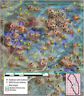
The effectiveness of helicopter well detection was evaluated by comparing airborne results with results from a ground search of a 0.2-sq-mi test area containing closely spaced wells, Fig. 3. High-accuracy GPS positions of all marked wellheads and certain other ferrous metal infrastructure were collected and entered into a GIS. The ground survey located 29 marked wells; all were within 50 ft of a corresponding well database location and were correctly named. However, the 29 wells found constitute only 39% of the 75 well locations in the NPR-3 well database for that area. Twenty-eight of the 29 validated wells (96%) were selected as magnetic targets by the helicopter survey. Forty-six wells in the NPR-3 database could not be located on the ground and were not targeted by the helicopter magnetic data. Of the 46 unfound and untargeted wells, 42 were less than 532 ft in total depth and designated as plugged and abandoned. Some wells, especially in the northeast corner of the test plot (Fig. 3), were less than 65.6 ft apart and probably were not resolved using helicopter magnetic data. Some helicopter magnetic targets not associated with well locations in the NPR-3 database may be undocumented wells, but a ground magnetic survey and excavation will be needed to confirm the wells’ existence.
 |
|
Fig. 3. Map showing GPS locations of ferrous metal features, well locations from the NPR-3 well database, and helicopter magnetic targets in a 0.2-sq-mi test plot within the airborne magnetic survey area at NPR-3. Background is a sun-shaded, color-scale map of TF magnetic intensity from the helicopter survey overlain on a geo-rectified air photo.
|
|
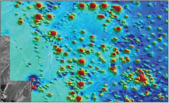
In the magnetic data from the NPR-3 survey, some well anomalies are much more intense than others. This was also seen in magnetic data acquired during the 2005 helicopter survey of Salt Creek Field.2 It was there that older wells were first observed to exhibit a stronger magnetic response than more recent wells. These observations were independent of total depth, as most wells were completed within a narrow range of depths. At NPR-3, early wells also exhibit a greater magnetic response in the helicopter magnetic survey data. To ensure that this measurement was not a gridding artifact or some other processing error, individual flight lines were first buffered to a 16.4-ft width and the magnetic signal profiles of the underlying well targets were extracted and examined in a GIS. The maximum grid-derived TF magnetic values for selected targets were then compared to the maximum flight-line TF magnetic values detected at the intersection of the targets and the buffered flight lines. Because magnetic response diminishes rapidly with distance, the dataset was further processed to exclude all targets significantly outside the planned survey altitude of 65.6 ft. An altitude window of 55.8-75.5 ft (one standard deviation) was selected. Figure 4 is a subset of magnetic anomalies meeting these criteria that depict wells drilled before 1930 (yellow dots). This figure shows the association of more intense TF magnetic anomalies with older wells (yellow dots). Most early wells (85%) were plugged and abandoned.
 |
|
Fig. 4. Dashed circles on this sun-shaded, color-scale map of TF magnetic intensity depict the location of wells drilled before 1930. Total well depths range between 1,500 and 3,100 ft; survey altitude was between 55.8 and 75.5 ft.
|
|
Limited areas of the helicopter magnetic survey were not terrain compliant (i.e., they were outside the altitude window) because of abrupt topographical changes and maneuvering to avoid obstacles. Terrain conformity in the NPR-3 airborne survey can be seen in the gridded laser altimeter data presented in Fig. 5. Deviations from the planned 65.6-ft altitude were coincident with steep terrain and power lines.
 |
|
Fig. 5. Absolute altitude grid derived from laser altimeter data.
|
|
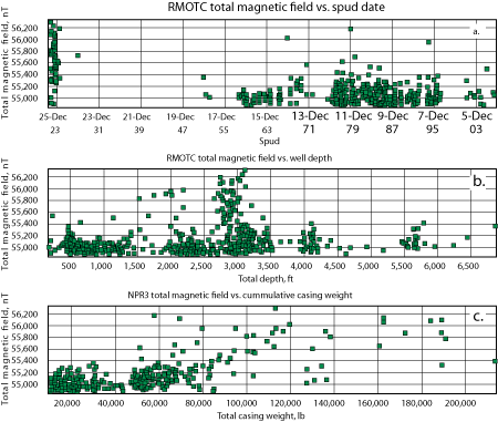
The spatially joined NPR-3 well database/magnetic target database was further interrogated to identify possible correlations between the observed TF magnetic intensity over a well target and attributes of that well such as casing length, diameter or mass. Figure 6a shows that most early wells at NPR-3 (before 1930) exhibited a significantly higher TF magnetic response compared to more recent wells. Figures 6b and 6c show only weak positive correlations when comparing total well depth and cumulative casing weight to TF magnetic response. Only magnetic target data intersecting the flight path and conforming to the prescribed survey altitude (±9.8 ft) were used in the comparisons.
 |
|
Fig. 6. Scatter grams depicting relationships between the total magnetic field intensity and well spud dates (a), total depth (b) and cumulative casing weight (c).
|
|
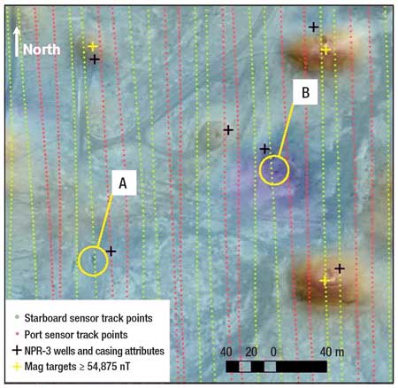
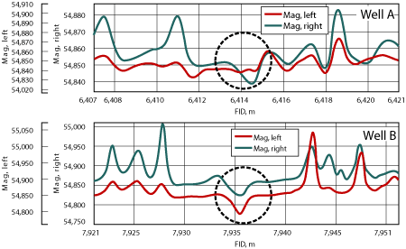
Many database wells produced very weak or undetectable TF magnetic responses. The majority of these “weak anomaly” wells were drilled more recently than 1970. Although high-resolution satellite imagery clearly shows pumping units or other surface evidence of wells near some NPR-3 well locations, no discernable positive TF magnetic anomaly is observed. One example (Fig. 7) shows negative anomalies in the gridded magnetic datasets, even though well pads and pumping units were observed in the imagery underlay and the well locations were confirmed in the database. In Fig. 7, a surface pumping unit is seen at location A. Ordinarily, a positive, monopole-type anomaly would be observed as with the surrounding wells and in most of the dataset. Well A is a producing well with a total depth of 2,024 ft and 440 ft of 85/8 in. steel casing that was completed in 1987. Well B (4,125-ft TD, steel-cased 85/8 in. to 531 ft, completed in 1977) also gives rise to an apparent negative anomaly. The ground tracks of both magnetic sensors are depicted in Fig. 7 to illustrate the interline data interval and to confirm that data were acquired almost directly over the features. The profiles in Fig. 7 show the TF magnetic responses from each sensor along segments of flight line over locations A and B. The flight altitude was 70.9 ± 1.3 ft over the entire data subset in Fig. 7.
|
|
|
Fig. 7. Magnetic field profiles along flight line segments over two known steel-cased wells. Total depths are 2,024 ft for Well A and 4,125 ft for Well B. The direction of flight over both wells was south.
|
|
The induced magnetization of steel well casing is known to be dependent on the strength of the inducing field, the casing’s diameter, length and orientation, and the magnetic susceptibility of the metal comprising the casing. The variation in the earth’s magnetic field (inducing field) across the NPR-3 survey is insufficient to explain the observed differences in the TF magnetic intensity. Scatter plots in Fig. 7 show that there is no strong positive correlation between the observed TF magnetic intensity and casing length or mass. All well casings were vertically oriented. Therefore, the differences in observed TF magnetic intensity must be attributed to differences in the metal casing’s magnetic susceptibility or remanent magnetism. Although no metallurgical data for the pipe used in the early wells in NPR-3 was found, presumably steel manufactured at different times or from different suppliers would have different metallurgical properties and differences in magnetic susceptibility. Many steel objects, like well casing, will develop remanent magnetization when manufactured, and the degree and direction of magnetization will depend on the manufacturing process, the location and even the direction relative to the earth’s magnetic field as the metal cools. Further cold-forging or machining for the metal will often reduce the magnetization. Separate segments of the casing may have magnetization in similar or different directions, enhancing or minimizing the total magnetic anomaly. Older wells may exhibit more remanent magnetism because well casings in early cable tool drilling operations would acquire magnetization,3 which caused difficulty measuring depths, as steel measuring tapes held to the casing wall. The magnetization was attributed to “jarring of the drilling tools.” Strong electromagnets were also used to retrieve lost tools. Cable tool drilling was used for the early wells at NPR-3, which might indicate that remanent magnetization contributes to the increased TF magnetic response above older wells.
The degree of corrosion can negatively affect the magnetic response of steel well casing because the products of corrosion are only weakly ferromagnetic. Anecdotal evidence from workers in this oil field suggests that newer casing is more susceptible to corrosion, which might explain the reduced magnetic response of newer wells. However, older wells have had longer to corrode. An evaluation of casing retrieved from wells with a wide variety of magnetic responses is needed to conclusively determine the cause of aberrant magnetic responses.
CONCLUSIONS
The helicopter magnetic survey at NPR-3 successfully located many well anomalies; well locations interpreted from TF magnetic anomalies were consistently more accurate than locations in the existing well database. Only 889 of 1,353 well records (66%) matched airborne or ground magnetic targets to within 50 ft. In areas of high well density, associating well locations from the database with well picks from the magnetic data is a formidable task. Some wells were too close together to be resolved and can be located with certainty only by ground-based magnetic surveys. There are likely to be undocumented wells at NPR-3 that can only be located by thorough ground reconnaissance guided by the results from the airborne magnetic survey. Conversely, there are well locations in the NPR-3 database that have been corroborated by high-resolution imagery but were not identified by the helicopter survey because magnetic anomalies were weak, absent or even negative. Most of the undetected wells were shallow (<500 ft) and relatively recent, drilled after 1970.
Variations in the TF magnetic response that cannot be explained by differences in casing length, diameter or mass may be due to differences in pipe metallurgy, and therefore, magnetic susceptibility. Enhanced remanent magnetism resulting from drilling practices in the cable tool era may have increased the magnetic response of early wells. 
ACKNOWLEDGMENTS
The authors thank RMOTC for granting access to the magnetic data and for providing well database information.
LITERATURE CITED
1 Friedmann, S. J. and V. Stamp, “Teapot Dome: Site characterization of a CO2-enhanced oil recovery site in Eastern Wyoming,” Lawrence Livermore National Laboratory, UCRL-JRNL¬217774, 2005.
2 Hammack, R. W., Veloski, G. and G. Hodges, “Helicopter surveys for locating wells and oilfield infrastructure,” presented at the International Petroleum Environmental Conference, San Antonio, Texas, Oct. 17-20, 2006.
3 Bowman, I., “Well-drilling methods,” USGS Water Supply Paper 257, 1911.
|
THE AUTHORS
|
| |
Garret Veloski is a chemist at the National Energy Technology Laboratory in Pittsburgh, PA. He studies the analysis of coal-derived complex mixtures, employing high resolution mass spectrometry, as part of an alternative fuels research program. He spent the past nine years of his career in a variety of projects perfecting new skills involving mapping and GIS, processing and analysis of optical remote sensing, and geophysical data sets. Garret received his BS and MS degrees in chemistry from Duquesne University in Pittsburgh.
|
|
| |
Richard Hammack is the leader of a research group at DOE’s National Energy Technology Laboratory that investigates the environmental impacts of oil and gas exploration and production activities. Specifically, the group investigates the impact of these activities on air emissions, the ecological impact on indigenous flora and fauna, and new methods to treat and manage produced water. The research group also develops airborne methods to locate abandoned oil and gas wells.
|
|
| |
Vicki Stamp has worked in the oil and gas industry since 1979, and has been associated with the Naval Petroleum Reserve No.3, Teapot Dome Field since 1993. She currently serves as the CO2 program manager, overseeing the portfolio of activities comprising the CO2 EOR and sequestration program at RMOTC. Her industry experience includes oil and gas reservoir engineering, operations engineering, thermal recovery, property evaluation and planning. She holds a BA from the University of Virginia, and an MS in petroleum engineering from Stanford University.
|
|
| |
Roger Hall has worked in and been associated with the oil and gas industry since 1982. He has reservoir and production operations experience along with regulatory experience with the US Environmental Protection Agency (EPA). He worked 11 years in underground injection control for the US EPA in Region 6 Dallas and in Region 5 Chicago. He holds a BS in chemistry and environmental science from East Central University, and a BS in petroleum engineering from the University of Oklahoma.
|
|
| |
Kenny Colina has 18 years’ experience as a professional engineer in the oil and gas industry. He has technical competencies as a project manager, comprehensive knowledge of computer programs to support Nodal analysis, monitoring of production and injection well performance, process analysis and simulation to improve and optimize control costs and reserve recovery. In addition, providing technical support to operate and maintain production facilities. Kenny has a BS in civil engineering from the University Rafael Urdaneta, Maracaibo, Venezuela.
|
|
|

