NOVA SCOTIA CANADA: GEOSCIENCE
Jurassic Carbonate Bank evaluation
Arthur G. Kidston, David E. Brown, Brenton M. Smith and Brian Altheim, Canada-Nova Scotia Offshore Petroleum Board, Halifax, Nova Scotia, CanadaThis 2005 study by the Canada-Nova Scotia Offshore Petroleum Board documents the geology of the Upper Jurassic Abenaki Formation carbonate platform, located along the edge of the continental margin, offshore Nova Scotia. The study area extends for 650 km from Sable Island southwest to the offshore Canada/United States border.
Within the Abenaki, three main depositional facies are recognized: an inner low-energy shelf, an outer high-energy shelf, including the bank edge, and a deeper water foreslope. Analogues to the Abenaki are similar aged strata along the US Atlantic margin, on the conjugate margin offshore Northwest Africa, and both US and Mexican Gulf of Mexico.
During Late Jurassic time, the circum-North Atlantic was fringed by carbonate platforms and related facies. This classic pull-apart, divergent passive margin setting was initiated during the break-up of Pangea during the Late Triassic period.
The Abenaki Formation is comprised of three members. The lowest is the Scatarie, which is an oolitic, oncolitic limestone with a deepening-upward transgressive cyclicity that forms a wedge-shaped, thickening seaward ramp. The middle member, Misaine, is a transgressive shale that reflects drowning of the shallow water Scatarie; the topmost Baccaro is the thickest member, attaining thicknesses in excess of 1,300 m and represents a series of stacked outer-shelf, carbonate bank facies. The Abenaki carbonate succession was drowned in the earliest Cretaceous by the advancing Sable deltaic complex from the northeast and seaward by the coeval source rock shales of the Verrill Canyon Formation.
Based on geological and geophysical characteristics, the NE-SW trending Abenaki carbonate platform and margin succession is subdivided into three segments: Panuke, Acadia and Shelburne.
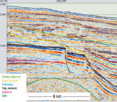 |
Thick sediments over salt body with growth and listric faulting along the Abenaki Formation.
|
|
The easternmost Panuke Segment is 120 km long and lies northwest of, and adjacent to, the Sable subbasin. The latest 3D seismic surveys were used for detailed mapping in time and depth. This area has 14 of the 21 exploration wells, seven on the bank edge, six in the back-reef, and one on the foreslope. EnCana’s Deep Panuke gas discovery was made on the bank edge in 1998. The earlier Cohasset and Panuke oil discoveries were in Cretaceous sands draped over the bank edge. It ultimately produced 44.4 MMbbl of oil. The central Acadia Segment extends 400 km from the edge of the Sable area to the Northeast Channel adjacent to George’s Bank. The modern 2D regional seismic survey by TGS-NOPEC was used to map this segment. Unlike the Panuke area, this segment is faulted, eroded and intruded by salt, but the confirmed presence of reefal facies bodes well for likely reservoir development. There are only seven wells in this area, three on the bank edge and four in the back-reef with no discoveries, but with reservoir indications and mud-gas shows.
The western Shelburne Segment is about 120 km long and includes the George’s Bank Moratorium area and extends to the offshore US border. This area is the least understood due to no wells and poor quality 1970s and 1980s vintage seismic data.
Of the 28 wells drilled from 1970-2004 on the Abenaki Platform in the study area, 10 were bank-edge wildcats, seven were delineation wells at the Deep Panuke Field, and 11 other wells were drilled either landward or basinward of the margin.
On the conjugate Moroccan margin, several wells encountered reservoir and degraded oil shows, but none of commercial value. To date, the prolific Mexican “Golden Lane” trend in the western Gulf of Mexico is the only region with production from Middle and Upper Jurassic carbonate bank margins in the circum-Atlantic realm. Development of EnCana’s Deep Panuke discovery will change this situation.
Twenty exploration wells that penetrated the Abenaki carbonate indicated extensive porosity development (over 900 m thick in one well), and gas on logs and in mud-gas readings. Study of the bank’s potential suggests there are at least four different play types associated with the bank feature.
TYPE 1-SUBTLE DRAPE IN OVERLYING SANDS
Early drilling focused on subtle structural highs along the bank edge. The 1973 Mobil-Texaco Cohasset D-42 well found the Baccaro member to be wet and/or tight. However, numerous thin overlying sands of the Cretaceous Logan Canyon Formation contained oil. Ten sands were calculated to have pay with three tests yielding 49-52º API oil. Canada’s first offshore project (COPAN) was produced from these sands and slightly deeper sands at Panuke field several kilometres to the southwest.
TYPE 2-REEF TALUS AND SLUMP BLOCKS
Listric faults along the paleoshelf margin facilitated the slumping of large quantities of bank-edge material. The faults can provide excellent migration pathways into the slope debris fans and adjacent reef margin. A current exploration target of BEPCo Canada, about 200+ km to the southwest of the Deep Panuke discovery, is a large detached slump block now resting on the slope and encased in basinal shales.
TYPE 3-BACK BANK BUILD-UPS AND OOLITIC SHOALS
There are a number of identified features that may hold potential for this play type. Hydrocarbons could be sourced from adjacent and encasing lagoonal shales. A study of the produced oils from the Cohasset-Panuke project indicates three different families, suggesting separate sources, one of which is lacustrine.
TYPE 4-BANK EDGE DOLOMITIZED POROSITY
The Baccaro reefal facies illustrates repetitive, cyclic seaward progradation and subsequent backstepping of the carbonate margin. Syndepositional mass-wasting and faulting along the unstable margin created migration pathways for dolomitizing and leaching fluids, respectively, that significantly enhanced reservoir quality. Potential hydrocarbons are sourced from adjacent Verrill Canyon Formation marine shales that migrate into the reef margin along the listric faults. This play concept forms the basis for gaining an understanding of the Deep Panuke gas discovery.
Early drilling did not find hydrocarbons but revealed two main play types: porosity in the bank-edge reefal build-ups and back-reef oolitic shoals on the platform interior. EnCana’s Deep Panuke Field, within the reef margin setting, is the first significant discovery made in the Abenaki. This discovery accentuates the great potential for similar accumulations along the 650 km long carbonate trend.
The Geological Survey of Canada published a resource assessment for the offshore region in 1989 based on well information available up to and including 1983. The bank was predicted to be oil-prone based on its proximity to the marine source rocks of the Verrill Canyon Formation. The resource assessment estimated a median expectation of 1.3 Tcf natural gas and 320 MMbbl of oil. In hindsight, their analysis has proven to be conservative. The Deep Panuke discovery of about 1 Tcf recoverable gas and the new data available since 1983, point to the need to re-evaluate the petroleum potential of this large geological feature. 
LITERATURE CITED
Kidston, A. G., Brown, D. E., Smith, B. and B. Altheim, The Late Jurassic Abenaki Formation, offshore Nova Scotia: A seismic and geologic perspective, Canada-Nova Scotia Offshore Petroleum Board, Halifax, Nova Scotia, 168p, 2005.
|

