 |
France |
|
New system saves time for hydrographic surveyors
Siobhan Lignon, iXSea, Marly-le-Roi, France
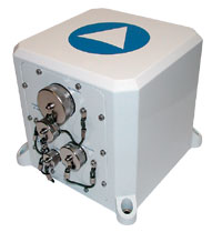
iXSea has launched HYDRINS, a new real-time solution for hydrographic surveyors. It is designed specifically to save on precious survey time. HYDRINS consists of a navigation system that interfaces with a multi-beam sounder to provide real-time, high-accuracy bathymetric data. These data are suitable for all surveys, especially multi-beam.
The design is based on the company’s expertise in the field of inertial products. There is a real-time management system for occasions when GPS drop-out occurs. An algorithm computes position (less than 1 m in 1 min.) during GPS downtime.
The system provides very good accuracy for H/R/P (0.02°/0.01°/0.01°), which improves the total error budget of the measurements. Additionally, the data accuracy of position, heading, attitude and motion is in real time. This feature breaks new ground in terms of the technology that already exists for navigational instruments. A self-adaptable filter provides heave in a real-time management system that also prevents height artefacts. There is no need for post-treatment of data. Again, this helps to save precious survey time.
Easy to install and operate, the system is quite versatile in terms of compatibility with all leading multi-beam manufacturers and all leading GPS manufacturers. The system is available as a stand-alone product and also as a complete survey package. 
|