The past, present and future of ocean bottom seismic systems - A Panel in Print
Panel in PrintThe past, present and future of ocean bottom seismic systemsThere currently exists a gap between what is possible in deepwater drilling and what is available in seafloor seismic systems. What will it take to close the gap?Perry A. Fischer, Editor
In what is almost a chicken and egg analogy, someone has to commit first to move this technology into widespread marine use, and eventually into even deeper waters. Equipment suppliers and service providers have shown their faith in the technology, as evidenced by multi-client ocean bottom cable (OBC) surveys and the recent introduction of 2,000-m (6,500-ft) rated OBC systems. For its part, BP has just contracted Seabed Geophysical AS, a Norwegian seismic contractor that specializes in 4C systems, to develop, build and test a prototype multicomponent system. Although this occurred too close to press time to cover – and details may be too tentative and proprietary in any case – the system will be a 4C, 250-node autonomous deployment designed to operate in 3,000-m (9,850-ft) waters. In a question and answer format, World Oil asked four industry experts about past experience, current capability, and what lies ahead in marine seafloor seismic – particularly, what problems need to be overcome. The panelists are: Larry Denver, Vice President of Reservoir Operations at Input/Output; Denis Mougenot, Chief Geophysicist for Sercel, France; Roger D. Entralgo, Project Manager of Seismic Development for Oceaneering Int’l; and Robert H. Tatham, Professor of Exploration Geophysics and Shell Centennial Chair in the Dept. of Geological Sciences, Jackson School of Geosciences, University of Texas – Austin.
Larry Denver and Denis MougenotQ. What is the current capability of Ocean Bottom Seismic (OBS) systems in terms of water depth? That is, what are the deepest retrievable and deepest permanently installed OBS systems? Denver State-of-the-art, retrievable ocean bottom systems provide data acquisition up to about 2,000 m. PGS and Sercel have fully commercialized, multicomponent cable. I/O is currently field testing its new buoy-based system, also designed for 2,000-m water depth. The system is equipped with our new multicomponent MEMS-based (Micro Electro Mechanical System) sensor and includes a design to decouple the sensor housing from the cable, while more effectively coupling to the ocean bottom. The permanent market has seen very few applications – especially when one considers the amount of discussion that has taken place about its potential over the last five or so years. The only permanent OBS application of any size today is deployed on BP’s Foinaven field in the North Sea. Geco deployed this OBS in 1995, equipped with only hydrophones, as requested. The system was installed in 450 to 500 m of water by trenching into the ocean bottom. The last 4D data was acquired in 1998. Another, more experimental, system was I/O’s Teal South, which was deployed in 1997. It was located in the GOM in about 90 m of water and supported by the Energy Research Clearing House (ERCH) consortium. The deployment had various objectives, including several coupling designs for permanent systems. Although the results have been inconclusive, one clear lesson learned was that unburied cables in 300-ft waters are subject to the perils of fishermen. Mougenot To our best knowledge there is no system that has been deployed long enough to be considered a permanent deployment, including Foinaven. However, BP does have a plan for a permanent system in the North Sea in the spring of 2003. Sercel is not aware of any system being deployed long enough to qualify as a proven "life of field" system. The Sercel system, as well as some of the other systems, is designed to be redeployed with the same depth limit as "permanent" installations. Q. What are some of the design considerations that have contributed to past failures and, therefore, need to be overcome to ensure future success in OBS systems? Denver Nearly every new technology in the petroleum industry has seen limited usage until cost and reliability achieved acceptable levels. Retrievable OBS technology has seen somewhat limited acceptance for those same reasons. Operational costs are still relatively high due to a number of factors, including: time and manpower to deploy the equipment and make it operational, acquisition geometry, and system reliability. All of these issues contribute to high operational costs relative to streamer acquisition. Retrievable OBS cables have most often been plagued by failures in the cable terminations due to the complexity of multiple wire transmission schemes and the takeouts. Other problematic design issues include:
In addition, most OBS products have relied on gimbaled sensors within the pressure housings to zero the tilt. Unfortunately, gimbals reduce data quality and cost more to machine. Low frequency (15 Hz) omni-directional geophones, recently introduced, can help eliminate mechanical gimbals; but they introduce other issues, including wide tolerances on specifications that change with tilt, higher distortion and limited coil travel. The uncertainty in measurements made with these geophones leads to large inferred ground motion vector errors. Higher frequency (28 – 30 Hz) omni-directional geophones have been available for many years, but have not been used for seabed applications due to the limit they impose on signal-to-noise ratio at low frequencies. The combination of these purely mechanical drawbacks and sensor limitations has contributed to a lack of overall vector fidelity. Vector fidelity has become a primary concern with operators. It is these challenges that have molded our thinking and driven our designs. Mougenot As there is little experience in the use of permanently installed deep monitoring systems, it is difficult to state a conclusive result of failure. However, if speculation is allowed, most failures should occur from: damage during deployment; failure of the cable to withstand pressure; electronics failure; and cable damage from seafloor activity in support of platform operations. Our product is based on proven components to avoid most of these problems. The cable is supplied by Nexans and has significant time in use on the ocean bottom as a proven product in different, but equally harsh, uses. The electronics are based upon the Sercel 408 UL, and the system offers multiple options of redundancy. Multiple power and telemetry wires offer backup in case of seawater leakage or damage during deployment or retrieval. When used for "life of field" operations, the Deep Sea Link can offer our Multi-path concept. This allows the operator to re-route the data in case of any damage or failure in the system. These concepts are imperative to achieve the "life of field" requirements of oil companies. One design consideration is the specific use of the system, i.e., whether the system should be designed for "permanent" deployment or for ongoing and frequent deployments. If the answer to this question was known, a product optimized for one application could be designed with maximum performance and proper cost parameters. Today, most systems are designed to support either mode of use. Target water depth has a direct influence on system cost. While most systems offered today are capable of 2,000-m depths, most reservoirs that are targets for this technology are in shallower water. Cost of these systems could be significantly lower if customized to meet shallower water depth targets. Without a better understanding of conditions that will be faced for the highest percentage of use, systems will be designed for the highest specification that can be met. Without this understanding in the design process, users with needs for more-permanent OBCs to be used in 900-m depths will need to pay for a retrievable system designed for 2,000-m depths. Q. There are now reservoirs whose depths prohibit today’s OBS systems. What’s on the drawing board for tomorrow? In the case of permanently installed systems, what are some of the options being considered for their installation, for supplying power and retrieving data? Denver Very deep retrievable systems remain somewhat of a challenge due to cable size limitations. Nevertheless, we believe cable-based designs could handle the same water depths as the deepest ROVs. As an example, a deployment design from Sonsub holds the entire cable in a basket near the bottom while an ROV or thrusters move the basket. The geophysical cable is then attached within the drum to an armored riser that serves to support the drum and to deliver power and telemetry. This method may simplify traditional processes. There are also designs for deploying cableless systems or autonomous nodes. These systems are either positioned with ROVs or made to find their way to the bottom and back to the surface. The challenge with these systems will be battery or other power supply (depending upon how long they need to be on bottom) and exact repositioning if the nodes must surface to harvest the data. In our opinion, both autonomous nodes and cabled systems will ultimately serve this market, and we are pursuing both. Depending upon the station spacing, the current level of ocean bottom infrastructure, the shot point interval and the HS&E criteria, either approach, or perhaps both, could be used on a single field, much as cabled and radio-based (autonomous nodes) recording systems are used today on land. Autonomous node designs are typically being considered where, due to existing infrastructure or exclusion zones, it is simply not practical to lay or bury cables. It is much easier to design a permanent deepwater system with a lower cost burden and better reliability, since it is only deployed once. We believe our MEMS-based sensor will help to eliminate several problems. The sensor has a spring-mass structure with a resonant frequency well above the typical seismic frequency band. This means that the sensor acts as an accelerometer and can collect data to DC with virtually no phase or frequency shift across the seismic band. It can also automatically determine its vertical orientation, eliminating the need for tilt sensors or gimbals. Since it has no magnet, traditional heading sensors can be used within the package. Also important to the placement of permanent sensors are the possible opportunities relating to infrastructure integration. Companies like ABB (Offshore Systems) now have the ability to support tiebacks from subsea infrastructure 200 km away. If such tiebacks prove able to supply power and telemetry infrastructure for OBS systems, costs will come down and reliability will improve. As new designs become more cost effective and data quality improves, ocean bottom acquisition will become routinely employed by E&P companies in reservoir development. Mougenot Sercel OBS systems have been developed based on a common, flexible architecture that has been field proven in land and marine environments. Extending the operational depth beyond 2,000 m can be readily done when the need develops. One of the advantages of permanently deployed OBS systems is that there is, typically, a working platform in the general area. This allows system connections to be brought to the surface as one of many support cables already installed around the platform. Telemetry media such as fiber optics could allow data to be transmitted over long distances with great reliability. The power issue can be solved, typically, only by designing systems that require smaller amounts of power for their operation. If that is a design criterion from the beginning, it is highly possible. Our 408UL has the lowest power requirements of any system available, and some future design goals include lowering power consumption even further. In this application, the more we know about the design targets, the closer we can get.
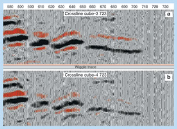
Roger EntralgoQ. What were the primary drivers for the Teal South consortium? The initial driver was to evaluate and prove that 4D technology was a valuable geophysical method to monitor reservoir fluid fronts. Identifying causes and ways to address acquisition footprint was another key element. However, as the project progressed to an operational stage, it became evident that engineering issues related to OBC installation needed much improvement, and eventually became one of the major drivers. There were many unknowns that could only be answered through a pilot project. For example, was there any benefit as to how the equipment was installed, that is, should the OBC be buried, as opposed to just sandbagging or laying it on the seafloor? There was also concern with the level of vector fidelity and whether the installation method would affect it, especially with respect to anisotropy. Q. What are some of the lessons learned from Teal South and other OBC research, and how do they relate to challenges with deepwater ocean bottom seismic acquisition? To date, experience with seabed time-lapse seismic is limited; only two experiments have been documented. Both pilots, a 4D-2C at Foinaven, in the North Sea, and a 4D-4C pilot at Teal South, in the Gulf of Mexico, were in relatively shallow water. Both pilots demonstrated the ability to acquire P-P compressional volumes that, using state-of-the-art processing of converted P-S data, were able to show changes in the reservoir due to production, Fig 1. However, it should be noted that P-S converted-mode processing is more demanding than is the P-P mode and still challenges the skills of the processor. Both pilot projects also showed that seafloor equipment is at risk if proper installation measures are not taken.
Oil companies willing to invest in OBC technology in deepwater fields have shown a growing interest in 4C sensors. The added cost of the horizontal components compared to a 2C system looks negligible, and acquiring the full vector field leads to better imaging and reservoir characterization. Current seafloor cable-installation methods require that bottom-mounted, acoustic release pop-up buoys be installed and connected at each cable end to enable cable recovery. An acoustic transducer sends a specific "ID" signal that releases a particular buoy. Once released, the buoy surfaces with an attached tether line that is connected to the cable end. In deepwater, this retrieval method is unreliable due to the amount of tether line needed to reach the surface. The tether line – housed within the pop-up buoy – needs improvement to avoid entanglement. Protection of thousands of feet of extra cable necessary for connection to the surface needs to be addressed. In addition, the acoustic signal used to release the buoy is limited in distance and does not function properly in ultra-deep water. Generally speaking, alternative data gathering / transmission methods may be necessary in deepwater environments. For example, fiber optic connection to a platform, perhaps via a subsea manifold or wellhead, would eliminate the need for retrieving the cable heads and would increase data download capacity. More importantly, this would allow continuous power to the cable systems, eliminating limitations related to batteries. Although the 4D concept is now established, a real time, permanent reservoir monitoring system is still under investigation. The main factors that affect the integrity of OBC equipment are: shrimp trawlers in shallower waters; in deepwater, high currents, seafloor instability, additional cable requirements, battery lifecycle and extreme pressure and temperature. Burial of seafloor equipment might resolve some of these concerns. ROVs will likely play a major role in future development of deepwater fields. Equipment installation, cable evaluation, cable repair, accurate sensor positioning / orientation and perhaps data retrieval will all be areas for ROV seafloor intervention. There are other challenges. Increasing water depths create added concerns with accurate sensor positioning / orientation and vector fidelity. In general, horizontal geophones are more affected by seafloor coupling than vertical ones. Additionally, an accurate model of mechanical properties of the seafloor in deepwater environments must be developed. Positioning accuracy and cable orientation are critical for successful 4D data processing and interpretation. Current methods to position seafloor sensors are: first-break analysis from seismic data, and high-frequency acoustics gathered from ranging devices placed near the sensor. The accuracy of both of these positioning techniques is not suitable for water depths greater than 2,500 m. The ability to reduce risk and maximize return using ocean bottom systems to water depths of 1,000 ft is currently a reality, but this technology becomes increasingly limited at greater depths. Equipment and installation cost and the unknown benefits from permanent systems are the key factors slowing down rapid implementation of this technology in deepwater. Several deepwater OBC acquisition systems are now available and are deepwater rated by their manufacturers. However, from a safety, cost and performance perspective, there is a need to learn how to properly deploy, bury, position, and maintain cables and 4C sensors on the seafloor in deep and ultra-deep water. Much work is also needed in extending equipment battery life, stabbing methods to connect cables to other seafloor production equipment, and methods for collecting data where no nearby facility is accessible. Lack of vector fidelity can be due to geometry of the sensor package and associated cable system; the weight, mass, internal quality and mounting of the sensor package, and finally, the housing of the hydrophone. Three ongoing research issues in this area are: 1) whether better fidelity can be achieved by burial of the sensors, 2) whether data processing can detect and compensate for all vector-fidelity issues, and 3) can node systems provide better vector fidelity than cable systems. As 4C interpretation matures, oil companies will provide quantitative constraints for contractors as to allowable departures from vector fidelity. Q. What are the future drivers for "instrumented oilfields" to become a reality in deepwater environments? There is a growing need to better characterize and monitor deepwater reservoirs. Real-time monitoring of reservoirs is one of the major goals for instrumented oil fields, particularly in deepwater and ultra-deepwater environments. Industry is looking at permanent systems for locating bypassed oil, optimizing injection programs and early field development, and for early facilities planning. These systems will reduce reservoir uncertainty and are particularly justified in high-cost environments such as deepwater. In addition, in areas with obstructions and limited access, towed streamers may not be possible, while permanently installed seafloor equipment is more economically and operationally feasible. In the foreseeable future, instrumented oilfields will allow on-demand reservoir monitoring, where field engineers have the ability to evaluate and take immediate action based on real-time 4D reservoir snapshots. Seismic, engineering and other permanently installed sensors will take various forms (e.g., surface, borehole, active, passive, pressure, temperature, saturation, EM and gravity) and must ultimately all be integrated. For this to happen, acquisition and processing costs, as well as OBC system costs, must be reduced to take advantage of multiple surveys. In addition, case studies need to be publicized, where benefits and "value added" are shown. Technology advancements that need to occur for rapid implementation of instrumented oilfields include:
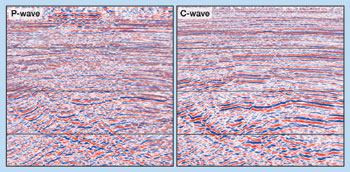
Robert TathamQ. What are the sources used to generate shear waves in a marine environment? In general, marine multicomponent seismic methods are similar to multicomponent on land, except that with marine seismic acquisition, direct generation of S waves, especially polarized S waves, is not feasible. Seafloor sources, which have only been tried experimentally – and never in deep water – would likely be limited to special applications, such as vertical seismic profiling. Either S- or P-wave seafloor sources could be developed, but the latter is operationally easier to accomplish, although it relies on partial conversion of P- to S-wave conversion at the reflectors (P to SV). Using current airgun source technology, S waves must be converted from P waves, and even then at some offset, since mode conversion does not occur at normal-incidence. Q. At the Jackson School of Geosciences, you have access to a considerable body of seismic research. What are some of the current and future uses of marine multicomponent technology? Since S and P waves respond differently to solids and fluids, simultaneous interpretation of both wave types can improve subsurface images and estimates of reservoir and fluid properties. However, to date, the use of multicomponent marine data has not been as great as the potential benefits would suggest. All of the following techniques are – to varying degrees – accepted by end users. Imaging through distortions caused by shallow gas is perhaps the most widely accepted use, such as occurred at Donald field, Fig. 2. Another application is detecting reservoir sands that have a poor response to conventional seismic. This occurs whenever the reservoir exhibits a marked difference in impedance contrast between that of P and SV waves. A widely cited example of this is Alba field in the North Sea. In general, whenever good correlation can be achieved between P wave and S wave (direct or SV) data sets, the Vp/Vs ratio may be useful in determining lithology and pore fluid. Other applications of multicomponent methods include direct detection and estimation of gas, and discrimination of lithology.
Another use is to include anisotropy for correcting images. These corrections were an important aspect of the improved images realized for Donald field. Interpretive models to correct for anisotropy effects in imaging are available, and end-users’ experience level is sufficient to use these data. There have been several reports of using anisotropy, particularly shear-wave splitting, to estimate fracture orientation and intensity. These reports have been for land data where a direct source of shear-wave energy was available. Polarization of shear-wave energy is a crucial aspect of these interpretations, and the controlled polarization of land shear-wave source certainly contributed to the success of these studies. Offshore, mode conversion is the shear-wave source. The present thought (speculation or hypothesis?) among researchers is that variations in source-receiver azimuth realized in 3D-4C surveys should provide enough information to fully address this limitation. Such a conjecture needs to be thoroughly evaluated before we have predicable interpretive models for fracture prediction from 4C marine data. Observations at Vacuum field in New Mexico have suggested that variations in shear-wave splitting may be related to fluid-pressure changes due to production. These suggestions are intriguing and appear to fit the data. There have not yet been enough observations to claim a predictive interpretive model for these fluid-pressure changes for widespread application. I feel that this application is still in the hypothesis stage and requires additional evaluation. As more results are obtained, publications should focus on educating potential users of this application. Suitability of 4C marine data is dependent upon mode conversion as a shear-wave source and shares some of the same concerns as fracture estimation. The AVO technique has been applied to P-P data to provide similar results that may, in principal, be attained with P-P/P-SV interpretations. Further, some experimental work addressing P-SV AVO, as well as P-P AVO is in progress by several research organizations. The objective of much of this research is discrimination of partial gas saturation. Currently, clear and predicable models do not exist. Its technical development is therefore not fully tested and developed. Early results, however, are encouraging. Q. What are some obstacles facing widespread 4C use? Problems acquiring quality 4C data have largely been resolved. However, there is a continuing concern in achieving full-vector, full-fidelity data. These concerns include seafloor conditions, such as inhomogeneity and anisotropy of sediments, acoustic coupling in hard grounds, and even processing the individually recorded components of ground motion. A remaining barrier to widespread application of 4C data has been the limited experience and understanding of the techniques by end users (asset team interpreters) of how to use these new data types. This may result from either a paucity of effective interpretive models or a failure of technology developers to communicate potential application techniques to the ultimate users. Success in faithfully recording the data – which is crucial to exploiting its potential – but failure to fully educate the end user in its use, will mean that 4C technology will not find rapid and widespread application in solving upstream petroleum problems.
|