Technology at Work: GPS surveying with helicopter-deployed stakes
Dec. 2001 Vol. 222 No. 12 Feature Article TECHNOL0GY AT WORK GPS surveying with helicopter-deployed stakes he oil and gas industry is continually reducin
TECHNOL0GY AT WORKGPS surveying with helicopter-deployed stakes
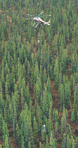
Calgary-based HeliStaker Corp. Ltd. has developed a heliportable device that enables surveying and staking to commence with significantly less time, cost and liability. As depicted in the photograph, the patented HeliStaker* device is suspended from a 115-ft-long line to survey and stake pre-plotted survey points. Although originally designed for seismic applications, the device has proved its versatility in the surveying industry. The technology has applications in forestry, mining, pipelines, power lines, seismic and wellsite leases. Environment. Restrictions and regulations on E&P and transportation methods have demanded a more specialized approach to protect the environment while maintaining resource development. Conventional surveying methods rely on line-of-sight to determine survey coordinates, which often require clearing a wide path. This adds unnecessary costs by increasing the amount of timber disturbed or destroyed. Global Positioning System (GPS) technology, together with airborne delivery, has transformed the surveying industry, greatly reducing timber damage normally incurred by conventional survey. It enables programs to be completed in much less time than traditional survey methods, as well as reducing occurrence of line deviations. This new technology eliminates blazing / clearing to maintain survey accuracy. As a result, timber-damage assessment fees, normally levied for traditional line-survey work, have been waived, and no reclamation costs have been incurred to date. Due to its minimal impact, government officials have recently granted the company permission to access restricted areas such as Critical Wildlife Zones where the ecosystem is delicate and responds adversely to major disruptions. Ground-based GPS problems. When using ground-administered GPS, problems sometimes occur. First, satellites require a clear line of transmission to adequately provide a receiver’s coordinates. In areas of dense canopy, ground GPS might not offer definitive readings. Poor signals or reflected satellite signals cause line deviations that require additional time for survey accuracy. Helicopter GPS eliminates these troublesome errors with an antenna well above the forest canopy. As illustrated, the GPS antenna is located 15 ft below the helicopter. This antenna position provides maximum satellite coverage to ensure survey quality and maintain a fixed-solution Real-Time Kinematic (RTK)-GPS coordinate. A laser targeting system is under development to further increase accuracy of stake placement in dense-canopy coverage, where visibility is hindered. The helicopter-deployed stakes offer an alternative method for surveying this type of difficult terrain while maintaining full satellite coverage and eliminating timber damage. Using a guidance camera to avoid treetops or unstable ground, the survey stake "gun," suspended at the end of the 115-ft-long line, is able to gently descend to the forest floor. Once in place, the pre-plotted coordinate is staked. Survey accuracy is ensured with RTK-GPS.
Production efficiency and accuracy. Survey crews using conventional methods or ground administered GPS typically cover 1 – 2 mi per day. This production depends largely on weather conditions and the type of terrain. Hostile terrain, such as the Continental Divide and areas north of 60° in western North America, challenges surveyors to accurately complete programs within an allotted time frame. The helicopter-deployed survey has successfully surveyed and staked these rugged areas at daily production rates of 15 – 20 mi, with high layout accuracy (within 3 m radially). Deviations are generally due to obstacle avoidance, such as trees. Accuracy of up to 10-in. RMS horizontally and vertically is realistically attainable for programs requiring higher precision. To ensure quality data with quick turnaround, data is immediately processed for client review. Field use example. A large program completed in northern Alberta, Canada, demonstrated the ability of the helicopter-deployed surveys to produce good results. The program comprised 992 mi and over 20,000 survey points. Using only one helicopter, the job was completed in 52 days; the equivalent production would have required 19 ground survey crews. Alberta forestry officials concurred that the use of the new survey technology left no environmental damage, and all timber damage assessment fees were waived, resulting in estimated timber-damage savings of $450,000. Thomas Radford, a geophysicist with BP Canada, saw all phases of the operation and was impressed with the quality of the line. He noted that the method reduced the cost of producing lines (both physical and timber-damage assessment costs), curtailed environmental impact and shortened survey-completion time. Radford congratulated the company on its efforts ". . . to provide an environmentally friendly, safe and productive operation that will benefit our industry, our environment and our companies, now and in the future." |
- Prices and governmental policies combine to stymie Canadian upstream growth (February 2024)
- U.S. producing gas wells increase despite low prices (February 2024)
- U.S. drilling: More of the same expected (February 2024)
- U.S. oil and natural gas production hits record highs (February 2024)
- Quantum computing and subsurface prediction (January 2024)
- U.S. upstream muddles along, with an eye toward 2024 (September 2023)
- Applying ultra-deep LWD resistivity technology successfully in a SAGD operation (May 2019)
- Adoption of wireless intelligent completions advances (May 2019)
- Majors double down as takeaway crunch eases (April 2019)
- What’s new in well logging and formation evaluation (April 2019)
- Qualification of a 20,000-psi subsea BOP: A collaborative approach (February 2019)
- ConocoPhillips’ Greg Leveille sees rapid trajectory of technical advancement continuing (February 2019)

